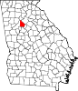
- Brookhaven, Georgia
-
This article is about the unincorporated community in DeKalb County, Georgia. For the portion of the historic neighborhood that lies in Atlanta, see Historic Brookhaven (Atlanta).
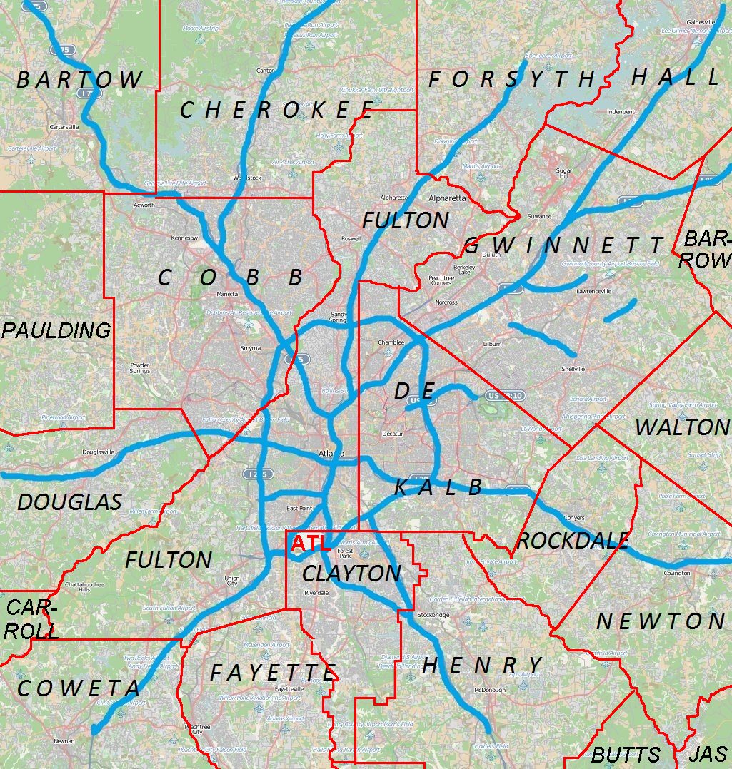
Brookhaven — Unincorporated community — Brookhaven Village, located on Dresden Drive east of Peachtree Location of Brookhaven in Metro Atlanta
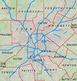
 Brookhaven
Coordinates: 33°51′33″N 84°20′20″W / 33.85917°N 84.33889°WCoordinates: 33°51′33″N 84°20′20″W / 33.85917°N 84.33889°W Country United States State Georgia County DeKalb Population (2008 estimate)[1] – Total 52,000 Time zone Eastern (EST) (UTC-5) – Summer (DST) EDT (UTC-4) ZIP codes 30319 Brookhaven is an unincorporated community located on the western edge of DeKalb County, Georgia, United States, directly northeast of Atlanta. Most of the area was formerly incorporated as the city of North Atlanta, which disincorporated during the 1960s. The North Atlanta name has been largely forgotten and replaced by "Brookhaven", a term used both locally and regionally to refer to the area. The community of roughly 52,000 recently began an incorporation movement, which, if successful, would make it the largest city in DeKalb County.[2]
Contents
History
Brookhaven's first permanent European settler was John Evans, who started a plantation around 1810. Harris and Solomon Goodwin, who moved to Georgia from South Carolina, become owners of the land in the 1830s. The Goodwin's original log cabin was later expanded into a larger home. It still remains in the family as a private residence, and is periodically open to the public. In addition to the antebellum home, the family graveyard still remains at the 3900 block of Peachtree Road near Dresden Drive.[3]
"Goodwin's" (also "Goodwin Station") was a station on the Atlanta and Richmond (later Atlanta and Charlotte) railway from the line's opening in 1873.[4] The settlement of Cross Keys, pop. 250 in 1876, was located one mile further north along the rail line from Goodwin's.[5]
Atlanta residents began constructing summer cottages in the community around 1900. Circa 1910, 150 acres (61 ha) on the north side of Peachtree Road was purchased for development as a planned community surrounding a golf course. The golf course was designed by Herbert Barker, a golf pro from Garden City, Long Island, with nine holes opening in 1912. The residential development was developed in three phases, with Brookhaven Estates designed in 1910, followed by Country Club Estates in 1929 and the Carleton Operating Company in 1936. Construction of the historic neighborhood was largely complete by the end of World War II. One of Atlanta's most exclusive private clubs, the country club became part of the downtown Capital City Club circa 1911 and became known as the Capital City Country Club. The golf course expanded from nine to eighteen holes in 1915. The clubhouse was designed by Preston Stevens in the French Provencial style, and completed in 1928. The Capital City Club is now listed on the National Register of Historic Places.[6]
 Capital City Club Golf Course
Brookhaven's Oglethorpe University was founded in 1835, but moved to its present location along Peachtree Road in 1915. It officially changed from a college to a university in 1965, and the campus is listed on the National Register of Historic Places. Marist School relocated to its present campus in North Brookhaven from downtown Atlanta in 1962.
From the 1950s to the 1970s, major residential development took place in Brookhaven, including the buildout of the Ashford Park, Drew Valley, Brittany, Silver Lake, Cambridge Park, Murphey Candler Park, and Hampton Hall subdivisions. The Brookhaven MARTA Station opened in 1984. In 1986, the Capital City Club and its surrounding estate homes were placed on the National Register of Historic Places.
The wealth of Brookhaven has increased in recent decades, and with a median household income of $236,393,[7] Brookhaven has become one of metropolitan Atlanta's most affluent communities.
In 2011, the community began an incorporation movement.[8]
The name "Brookhaven"
The definition of Brookhaven has varied as either:
- Historic Brookhaven, a core group of neighborhoods around the Capital City Country Club
- The area listed above, but including Peachtree Road in between Kendrick Drive and Club Drive
- A larger area extending north, east, and south of Historic Brookhaven to the Dunwoody, Chamblee, and Atlanta city limits, respectively, including neighborhoods such as Ashford Park, Hampton Hall, Byrnwyck, Murphey Candler Park, and one side of Buford Highway
- An even larger area, covering the proposed city of Brookhaven, going as far south as I-85, including all of Buford Highway and neighborhoods such as Lenox Park
Geography
Brookhaven is east of Sandy Springs and Buckhead, west of Chamblee, north of Buford Highway and south of Dunwoody. The proposed city of Brookhaven extends south to I-85, including the Buford Highway community and Lenox Park.
Brookhaven is located at 33°52′47″N 84°21′6″W / 33.87972°N 84.35167°W (33.879722, -84.351667)[9].
Demographics
North Atlanta, Georgia — CDP — Location in DeKalb County and the state of Georgia
Country United States State Georgia County DeKalb Area – Total 7.8 sq mi (19.9 km2) – Land 7.7 sq mi (19.8 km2) – Water 0.1 sq mi (0.1 km2) Elevation 1,004 ft (306 m) Population (2010) – Total 40,456 – Density 5,187/sq mi (2,033/km2) Time zone Eastern (EST) (UTC-5) – Summer (DST) EDT (UTC-4) ZIP code 30319 Area code(s) 404 FIPS code 13-56000[10] GNIS feature ID 0332512[11] Historical populations Census Pop. %± 1980 30,521 — 1990 27,812 −8.9% 2000 38,579 38.7% 2010 40,456 4.9% source: [12] Ther 2010 census counted 40,456 residents in the North Atlanta CDP.
The 2000 census counted 38,579 people, 15,886 households, and 7,402 families residing in the North Atlanta CDP. The population density was 5,040.6 people per square mile (1,947.1/km²). There were 16,636 housing units at an average density of 2,173.6/sq mi (839.6/km²). The racial makeup of the CDP was 61.52% White, 17.56% African American, 0.41% Native American, 4.88% Asian, 0.05% Pacific Islander, 12.64% from other races, and 2.94% from two or more races. Hispanic or Latino of any race were 27.41% of the population.
There were 15,886 households out of which 18.5% had children under the age of 18 living with them, 33.3% were married couples living together, 7.4% had a female householder with no husband present, and 53.4% were non-families. 35.0% of all households were made up of individuals and 4.4% had someone living alone who was 65 years of age or older. The average household size was 2.35 and the average family size was 3.04.
In the CDP the population was spread out with 15.6% under the age of 18, 15.2% from 18 to 24, 47.2% from 25 to 44, 15.7% from 45 to 64, and 6.2% who were 65 years of age or older. The median age was 31 years. For every 100 females there were 121.9 males. For every 100 females age 18 and over, there were 124.2 males.
The median income for a household in the CDP was $52,333, and the median income for a family was $52,679. Males had a median income of $35,742 versus $37,043 for females. The per capita income for the CDP was $32,087. About 7.6% of families and 11.8% of the population were below the poverty line, including 16.1% of those under age 18 and 9.0% of those age 65 or over.
Incorporation movement
The idea of incorporating Brookhaven as a city was first brought up in 2007, with the purpose of securing local community control over planning, zoning, and land use, rather than having these issues decided from downtown Decatur, and to gain local control over services such as police, fire protection, and parks and recreation.[13] However, the idea failed to gain momentum. The proposed city would include 52,000 people. [14]
In 2011, the incorporation of Brookhaven was revived when state Rep. Mike Jacobs announced plans to introduce legislation allowing the creation of a city of Brookhaven. Jacobs said he decided to introduce the proposal after a poll he commissioned found more residents of Brookhaven wanted to be a new city rather than seek annexation into the existing cities. The proposed city would be bounded by:[15][16]
- the Fulton County line on the west
- I-85 on the south
- Clairmont Road, the city of Chamblee at Chamblee Dunwoody Road on the east, and
- the city of Dunwoody at I-285 on the north
In October 2011, Citizens for North DeKalb (C4ND) announced the final geographic boundaries of the proposed city that the Carl Vinson Institute of Government at the University of Georgia will study.
Education
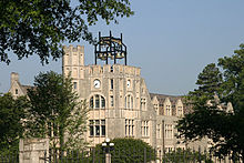 Oglethorpe University, located on Peachtree Road
Colleges and universities
- Oglethorpe University, 4484 Peachtree Rd., +1 404 261-1441.
- Georgia State University, 4362 Peachtree Road. GSU has a satellite campus in Brookhaven for their Robinson College of Business MBA program.
Elementary and secondary schools
DeKalb County School System operates public schools. DeKalb County public elementary schools serving the community include Dresden Elementary, Montgomery Elementary, Ashford Park Elementary and Woodward Elementary.
The public secondary schools are Chamblee Middle School, Sequoyah Middle School, Chamblee High School, and Cross Keys High School.
Private elementary and secondary schools include Our Lady of the Assumption Catholic School, St. Martin in the Fields Episcopal School and the Marist School, which is also Catholic and located on Ashford Dunwoody Road.
Public libraries
DeKalb County Public Library operates the Brookhaven Library.[17]
Neighborhoods/districts
 A street-sign topper of Murphey Candler Park, a residential neighborhood located in North Brookhaven
Historic Brookhaven
Historic Brookhaven is the historic residential neighborhood from which the area derives its name. It has homes surrounding the Capital City Club ranging from $800,000 to $4,000,000, many designed by a number of well-known Atlanta architects of the pre-war period. The neighborhood boundaries are well defined, and it stretches from Peachtree Dunwoody Road on the west, Windsor Parkway to the north, Mabry Drive to the east, and Peachtree Road to the south. A majority of the neighborhood technically lies within Buckhead and the extreme northeastern tip of the city of Atlanta.
Brookhaven Village
Brookhaven Village is the name given to the village-like town center that has emerged on Dresden Drive, just south of the Brookhaven MARTA station, anchored by the Village Place and Village Park Place mixed-use developments. The village is bordered by the residential neighborhoods of Ashford Park to the north and Drew Valley to the south, both offering single family homes within walking distance of the village. The village is home to a unique array of commercial establishments, including a pub, a coffeehouse, and an art gallery. The village also provides loft-style and urban residential options, as well as offices.[18]
North Brookhaven
North Brookhaven refers to the once-ambiguous area that previously merged into unincorporated Dunwoody and Perimeter Center. As a result of Dunwoody's incorporation, the area has become a part of Brookhaven by default, due to the fact that it lies sandwiched in between the boundaries of three cities -- Sandy Springs, Dunwoody, and Chamblee. The area is home to many residential subdivisions, including Cambridge Park, Hampton Hall, Brittany, Murphey Candler Park, Byrnwyck, and Silver Lake Estates. The area is also home to two large DeKalb County parks -- Blackburn Park and Murphey Candler Park. A commercial shopping center, Cambridge Square, forms the heart of the district, and lies at the intersection of its two major thoroughfares, Ashford Dunwoody and Johnson Ferry Roads.[19][20][21]
Lynwood Park
Lynwood Park was once a historically black enclave of wood and cinderblock homes in the small area north of Windsor Parkway, west of Osborne Road, and east of the Sandy Springs city limit. In the last decade, it has become a place where affluent newlyweds and middle-class dreamers come to build their fantasy Victorian-style craftsman homes. The transition in the neighborhood has been astonishing, and while the gentrification slowed since the Late-2000s recession, the neighborhood remains an attraction for those seeking a new home in a close-in location.[22][23] The community is also home to a large park, DeKalb County's Lynwood Park, which features a basketball court, tennis court, swimming pool, recreation center, playground and picnic area.[24]
Peachtree Road
Peachtree Road connects Brookhaven to Buckhead and travels northeast through the area, becoming Peachtree Boulevard at the Chamblee city limits. Much of Brookhaven's commercial developments are situated along Peachtree, including Town Brookhaven (see below), Brookhaven MARTA Station, Brookhaven Station shopping center, the historic Goodwin House, and Brookhaven Park. Situated along Peachtree is Town Brookhaven, a 600,000 square feet (56,000 m2) mixed-use district. It was developed by the Sembler Company, who also developed Lindbergh and Edgewood shopping centers, Perimeter Place in Dunwoody, and the Prado in Sandy Springs. It is located at Peachtree Road and Town Boulevard (formerly Cross Keys Drive), adjacent to Oglethorpe University. In addition to major commercial tenants, there are more than 1500 residential units and 150,000 square feet (14,000 m2) of office space.[25][26][27]
Buford Highway
Main article: Buford HighwayThe Buford Highway corridor forms the southern portion of Brookhaven. The corridor is characterized by apartment complex with a large Hispanic residential population. Buford Highway itself is famous throughout Metro Atlanta for its ethnic restaurants and businesses catering to a variety of ethnic groups, including Hispanic, Chinese, Vietnamese and Korean.
Lenox Park
Main article: Lenox Park, GeorgiaLenox Park is a former country club re-purposed for residential and office space, in the southwest corner of Brookhaven, located between Roxboro Road and North Druid Hills Road, just north of Buford Highway. It is home to the headquarters of AT&T Mobility.
Parks
 The lake at Murphey Candler Park
- Ashford Park, 2980 Redding Rd. 3-acre (1.2 ha) DeKalb County park with basketball & tennis courts, as well as a playground.
- Blackburn Park, 3493 Ashford-Dunwoody Rd. Includes the Blackburn Tennis Center, this 49-acre (20 ha) DeKalb County park has tennis and basketball courts, soccer fields, picnic areas and trails.
- Brookhaven Park, 4158 Peachtree Rd. 9-acre (3.6 ha) DeKalb County park with multi-use courts, playground, picnic area and trails.
- Murphey Candler Park, 1551 W Nancy Creek Dr. 135-acre (55 ha) DeKalb County park known primarily for baseball and football, but it also has a pool and lake.
Transportation
- Ashford-Dunwoody Road. The main north-south access to Brookhaven from Interstate 285.
- Brookhaven MARTA station, 4047 Peachtree Rd. The MARTA rail station located in the heart of Brookhaven.
- Peachtree Road. The main east-west road, providing access from Atlanta and Chamblee. The road was historically known as "Peachtree Road" in Fulton County, and "Peachtree Industrial Boulevard" in DeKalb County. However, the City of Chamblee, Georgia, (in DeKalb County) dropped "Industrial" from the name, so the road is now known as Peachtree Blvd. in the portion of DeKalb County that is inside I-285.[28]
- North Druid Hills Road. The main north-south access to Brookhaven from Interstate 85.
References
- ^ http://thecrier.net/articles/2007/07/27/front/city.txt
- ^ http://thecrier.net/articles/2007/07/27/front/city.txt
- ^ http://www.historicbrookhaven.org/history.htm
- ^ "goodwin station"&brand=atlnewspapers-brand "The Air-Line', Weekly Constitution, Aug. 26, 1873
- ^ "goodwin station"&brand=atlnewspapers-brand "Atlanta's Allies: The Great Feeders for Our Metropolitan City", Atlanta Weekly Constitution, September 26, 1876
- ^ "[1]" National Register of Historic Places: DeKalb County Retrieved: 18 August 2008.
- ^ http://higley1000.com/about-this-site/methodology/neighborhoods-by-metro
- ^ http://www.reporternewspapers.net/2011/03/24/jacobs-propose-law-creating-city-brookhaven/
- ^ "US Gazetteer files: 2010, 2000, and 1990". United States Census Bureau. 2011-02-12. http://www.census.gov/geo/www/gazetteer/gazette.html. Retrieved 2011-04-23.
- ^ "American FactFinder". United States Census Bureau. http://factfinder.census.gov. Retrieved 2008-01-31.
- ^ "US Board on Geographic Names". United States Geological Survey. 2007-10-25. http://geonames.usgs.gov. Retrieved 2008-01-31.
- ^ "CENSUS OF POPULATION AND HOUSING (1790-2000)". U.S. Census Bureau. http://www.census.gov/prod/www/abs/decennial/index.html. Retrieved 2010-07-31.
- ^ http://www.reporternewspapers.net/2010/03/11/should-brookhaven-be-a-city/
- ^ http://thecrier.net/articles/2007/07/27/front/city.txt
- ^ http://brookhaven.patch.com/articles/second-town-hall-meeting-scheduled-to-discuss-brookhaven-cityhood#pdf-5444966
- ^ http://www.reporternewspapers.net/2011/03/24/jacobs-propose-law-creating-city-brookhaven/
- ^ "Library Locations & Hours." DeKalb County Public Library. Retrieved on February 24, 2010.
- ^ http://www.jezebelmagazine.com/ArticleView.aspx?article=fe634cc3-5a2e-4d58-8a40-2233b762f366
- ^ http://thecrier.net/articles/2008/02/12/front/azoning.txt
- ^ http://thecrier.net/articles/2007/01/17/front/nancycreek.txt
- ^ http://thecrier.net/articles/2010/07/06/front/i285.txt
- ^ http://clatl.com/atlanta/lynwood-park-pressure/Content?oid=1248498
- ^ http://clatl.com/atlanta/lynwood-park/Content?oid=1231244
- ^ http://www.reporternewspapers.net/tag/friends-of-lynwood-park/
- ^ http://www.sembler.com/gallery.php?id=35
- ^ Rachel Tobin Ramos and Ty Tagami, "Disputed Brookhaven project gets lift", Atlanta Journal-Consitution, August 27, 2009
- ^ Ty Tagami, "Whatever happened to ... Jeff Fuqua?", Atlanta Journal-Constituition, June 10, 2011
- ^ Atlanta Journal Constitution, 19 AUG 2008
Bibliography
- "National Register of Historic Places Inventory-Nomination Form", December, 1985. Historic Preservation Section, Georgia Department of Natural Resources and with the National Park Service, U.S. Department of the Interior, Washington, D.C.
- Brannen, Bettie. "Brookhaven History." 1991. Published in the "Neighborhood Directory," Brookhaven-Club Neighborhood Association, 1995.
- Maddox, Robert F. "History." published in "Governing Board; Constitution and Rules; Membership," Capital City Club, March 1992, p. 4.
External links
- Brookhaven Directory
- Buckhead Website: Brookhaven
- Brookhaven Neighborhood Association
- Brookhaven Fields Civic Association
- HillsDale Neighborhood
- Citizens for North DeKalb (C4ND) - citizens' group exploring formation of new City of Brookhaven or annexation into either Chamblee or Dunwoody
Metro Atlanta Counties 
Major city Municipalities & communities 100k-250k 25k-100k Alpharetta • Brookhaven • Candler-McAfee • Duluth • Dunwoody • East Point • Gainesville • Johns Creek • Lawrenceville • Mableton • Marietta • Milton • Newnan • Peachtree City • Peachtree Corners • Redan • Smyrna • Tucker10k-25k Acworth • Belvedere Park • Buford • Carrollton • Cartersville • Chamblee • College Park • Conyers • Covington • Decatur • Doraville • Druid Hills • Douglasville • Fayetteville • Forest Park • Griffin • Kennesaw • Suwanee • Lilburn • Monroe • Mountain Park • North Decatur • North Druid Hills • Panthersville • Powder Springs • Riverdale • Snellville • Stockbridge • Sugar Hill • Union City • Vinings • Winder • WoodstockTopics Architecture • Culture • History • Media • Neighborhoods • People • Tourism • Transportation Municipalities and communities of DeKalb County, Georgia Cities Atlanta‡ | Avondale Estates | Chamblee | Clarkston | Decatur | Doraville | Dunwoody | Lithonia | Pine Lake | Stone Mountain
CDPs Unincorporated
communitiesBrookhaven | Embry Hills | Lenox Park | Northlake | Pittsburg | Smoke Rise | Vista Grove
Ghost town Footnotes ‡This populated place also has portions in an adjacent county or counties
Historic Districts in Metro Atlanta Clayton County 
Cobb County Coweta County Grantville · Newnan: Cole Town · Greenville St.-LaGrange St. · Newnan Commercial · Newnan Cotton Mill and Mill Village · Northwest Newnan Residential · Platinum Point · Roscoe: Roscoe-Dunaway Gardens · Sargent · SenoiaDeKalb County Atlanta: Candler Park · Druid Hills · Inman Park-Moreland · Kirkwood · Avondale Estates · Brookhaven: · Oglethorpe University · Decatur: South Candler Street-Agnes Scott College ·Winnona Park · Druid Hills: Emory Grove · Emory University District · University Park-Emory Highlands-Emory Estate · Stone MountainDouglas County Fulton County Atlanta: Adair Park · Ansley Park · Atkins Park · Atlanta University Center · Berkeley Park · Brookhaven · Brookwood Hills · Cabbagetown · Castleberry Hill · Collier Heights · Druid Hills · Fairlie-Poplar · Fox Theatre Historic District · Garden Hills · Georgia Tech · Grant Park · Hotel Row · Howell Interlocking · Knight Park-Howell Station · Inman Park · Inman Park-Moreland · King Plow/Railroad Historic District (proposed) · Knox Apts., Cauthorn House and Peachtree Rd. Apts. · Lakewood Heights · Martin Luther King, Jr., National Historic Site · Means St. · Midtown · Mozley Park · Oakland City · Peachtree Highlands-Peachtree Park · Pittsburgh · Reynoldstown · Southern Ry. North Ave. Yards · Sunset Ave. (proposed) · Sweet Auburn · Techwood Homes · Underground Atlanta · Virginia Highland · Washington Park · West End · Whittier Mills
College Park · East Point: Industrial District · Fairburn · Hapeville · RoswellGwinnett County Hall County Clermont · Flowery Branch · Gainesville: · Brenau College · Chicopee Mill and Village · Gainesville Commercial · Green Street · Green St.-Brenau · Gillsville · LulaNewton County Covington · Covington Mills and Mill Village · Floyd Street · Newborn · North Covington · Oxford · Porterdale · StarrsvilleRockdale County Conyers: Commercial · ResidentialCategories:- Atlanta metropolitan area
- Unincorporated communities in Georgia (U.S. state)
- Census-designated places in Georgia (U.S. state)
- Former municipalities in Georgia (U.S. state)
- Populated places in DeKalb County, Georgia


Wikimedia Foundation. 2010.