- Trunk Line Bridge No. 1
Infobox_nrhp2 | name =Trunk Line Bridge No. 1
nrhp_type =
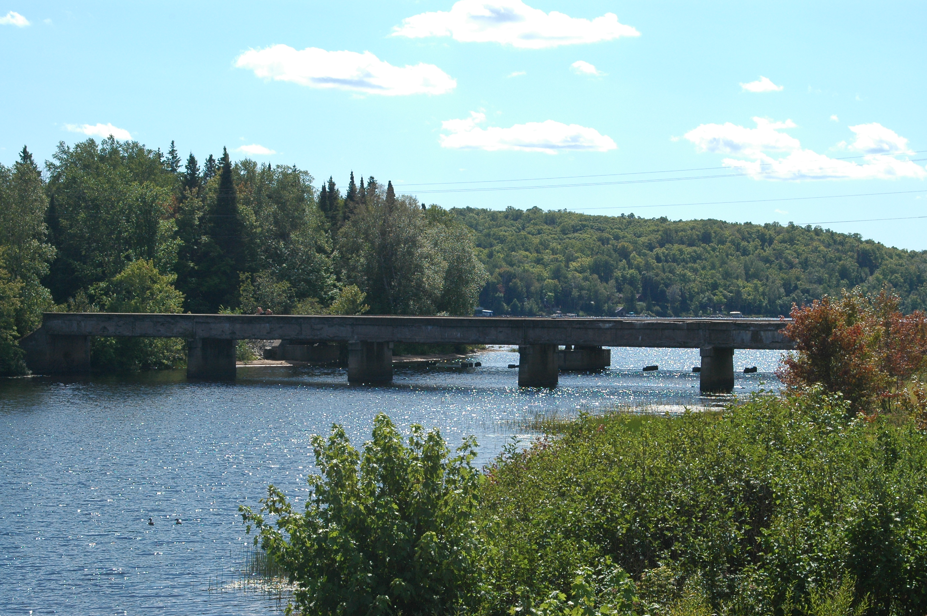
caption = Abandoned Peshekee River Bridge in Michigamme Township
location= Old US 41/M-28 overPeshekee River ,Michigamme Township, Michigan
lat_degrees = 46
lat_minutes = 31
lat_seconds = 42
lat_direction = N
long_degrees = 88
long_minutes = 0
long_seconds = 13
long_direction = W
locmapin = Michigan
area =
built =1914
architect= Powell and Mitchell; Michigan State Highway Department
architecture= Other
added = December 17, 1999cite web|url=http://www.nr.nps.gov/ |title=National Register Information System|date=2008-04-15|work=National Register of Historic Places|publisher=National Park Service]
governing_body = Local
mpsub= [http://www.nr.nps.gov/multiples/64500271.pdf Highway Bridges of Michigan MPS]
refnum=99001530Trunk Line Bridge No. 1,The bridge is incorrectly listed as "Truck Line Bridge No. 1" in the National Register Information System (NRIS) database, hence it is also incorrectly listed in various websites echoing the public domain NRIS data. Its correct name, using "Trunk" not "Truck", is clear from the Michigan Department of Transportation webpage on the bridge and also in the context given in the National Register's own Highway Bridges of Michigan MPS, another reference here.] also known as Peshekee River Bridge, is a bridge on US 41/M-28. It was the first of many trunk line bridges designed by the Michigan State Highway Department.cite web | title=US 41 (Abandoned) / Peshekee River Bridge | date=April 23, 2002 | publisher=Michigan Department of Transportation | url= http://www.michigan.gov/mdot/0,1607,7-151-9620_11154_11188-30382--,00.html | accessdate=2008-01-18 ] citation|title=PDFlink| [http://www.nr.nps.gov/multiples/64500271.pdf National Register of Historic Places Multiple Property Submission: Highway Highway Bridges of Michigan, 1875-1948] |32 KB|date=1999 |author=Charlene K. Roise et al. |publisher=National Park Service] It was built in 1914, and listed on the
National Register of Historic Places in 1999.Description
Trunk Line Bridge No. 1 is is a multiple-span concrete bridge which is located convert|5|mi|km|0 west of Michigamme. The bridge used to carry US 41/M-28 across the Pesheskee River near the river's mouth at
Lake Michigamme . It is located between aSoo Line railroad bridge to the south and the modern replacement bridge to the north.The bridge is convert|240|ft|m|0 in length, composed of six convert|40|ft|m|0|adj=on concrete through girders. This carries a concrete deck and full-height abutments over solid concrete piers with bullnosed cutwaters. In total, it used some convert|600|cuyd|m3|0 of concrete in the design. The girder walls feature rectangular recessed panels capped by concrete copings.
History
Today, drivers cannot use the Peshekee River Bridge south of US 41/M-28 in western Marquette County's Michigamme Township. The bridge was built in 1914 in response to the 1913 State Trunk Line Act passed by the
Michigan Legislature . This act designated a state trunkline highway network of nearly convert|3000|mi|km|0. The act further said that the Michigan State Highway Department would design, build and maintain trunkline bridges spanning convert|30|ft|m|0 or more so long as the local governments improved an adjacent convert|3|mi|km|1 of roads. Marquette County built a mainline road from Marquette west to Michigamme near the county line, including an improved convert|3|mi|km|1|adj=on section in 1913 to encourage the state to build the bridge. The bridge was designed by C.V. Dewart for the department and built by the local firm of Powell and Mitchell in Marquette. The Peshekee River Bridge would later be incorporated into the routing of US 41 in the 1920s.The bridge was listed on the National Register of Historic Places in 1999 as "Trunk Line Bridge No. 1" for its engineering and architectural significance.cite web |title=National Register of Historic Places - Michigan (MI), Marquette County | date=1999 |work=
National Register of Historic Places |url=http://www.nationalregisterofhistoricplaces.com/MI/Marquette/state.html | accessdate=2008-02-12 ] MDOT has listed it as "one of Michigan's most important vehicular bridges." It was the first bridge designed by the Michigan State Highway Department, the forerunner to MDOT, in 1914. It was bypassed by a new bridge built over the Peshekee River on US 41/M-28 in 1995 and subsequently abandoned as a roadway.cite web |title=Projects |publisher= A. Lindberg & Sons, Inc |url=http://www.lindberginc.com/projects.htm |accessdate=2008-02-13 ]ee also
*
List of bridges on the National Register of Historic Places in Michigan Notes
References
External links
* [http://www.michigan.gov/mdot/0,1607,7-151-9620_11154_11188-30382--,00.html US-41 (Abandoned) / Peshekee River] , at Michigan Department of Transportation
Wikimedia Foundation. 2010.