- Mount Elsay
-
Mount Elsay 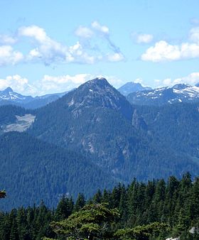
Mount Elsay seen from Eagle Peak in the EastElevation 1,419 m (4,656 ft) Prominence 254 m (833 ft) Location Location British Columbia, Canada Range Fannin Range, North Shore Mountains, Pacific Ranges Coordinates 49°24′24.8″N 122°56′13.9″W / 49.406889°N 122.937194°W Topo map NTS 92G/07 Climbing First ascent 1909 Unnamed BCMC party Easiest route trail Mount Elsay is a mountain in southwestern British Columbia, Canada, located 14 km (9 mi) northeast of North Vancouver near the middle of Mount Seymour Provincial Park in the District of North Vancouver. It is a part of the North Shore Mountains, rising from the shores of Indian Arm to a summit of 1,419 m (4,656 ft). In 1909 it was originally named Mt Jarret in honour of George Jarret, a South African who became the first secretary of the British Columbia Mountaineering Club (BCMC).[1] It has subsequently be re-named Mount Elsay, after nearby Elsay Lake and Creek. These names are thought to derive from a Scottish settler, probably after a place name in Scotland.[2]
Contents
History
The first ascent of Mount Elsay was made in 1909 by a party of climbers from the British Columbia Mountaineering Club led by Fred Mills. The mountain was approached by boat to the top of Indian Arm, opposite Crocker Island, where the group camped overnight. In the morning they broke into two groups, the others climbing Mount Bishop and headed up Bishop Creek. Among the Bishop party was a Mr Cromie, former owner of the Vancouver Sun. Upon reaching the summits of the two mountains at about 9.30am, the two parties of climbers called to each other. Fred Mills' memoirs and photographs are to be found at the North Vancouver Museum and Archives.[3]
Hiking Routes
Unlike the nearby Mount Seymour, Elsay is not visited by hikers with much frequency. Two routes are most popular; the best hike is to go out by one and return by the other. The West Trail is reached by hiking toward Mount Seymour, then bearing left (west) in the saddle between Second and Third Peaks. A rough route poorly marked with tapes takes one around Mount Seymour's West flank, across the gully below Runner Peak, then trends upward to the ridge, then a rock face to the summit. Alternately, the Elsay Lake Trail takes one to the East of Mount Seymour, across several rock slides, then up a large talus slope (bear right to the low point of the ridge) to join the other trail on the south shoulder of the mountain. The route to Vicar Lakes, Mount Bishop and the Indian Arm Trail heads left shortly after the ridge starts to rise to Mount Elsay. The Peak is flanked by Mount Bishop and Elsay Lake on the North, with Mount Seymour and Runner Peak to the South. This is rough backcountry and should be approached only with caution and experience.
References
- ^ "Mount Elsay". BC Geographical Names. http://apps.gov.bc.ca/pub/bcgnws/names/2861.html.
- ^ "Elsay Lake". BC Geographical Names. http://apps.gov.bc.ca/pub/bcgnws/names/2858.html.
- ^ http://bivouac.com/PhotoPg.asp?PhotoId=5260
External links
- "Mount Elsay". Bivouac.com. http://www.bivouac.com/MtnPg.asp?MtnId=557.
- "Mount Elsay". North Vancouver Archives.
- "Mount Elsay". British Columbia Mountaineering Club.
Categories:- Mountains of British Columbia
- North Vancouver (district municipality), British Columbia
- Pacific Ranges
- British Columbia Coast geography stubs

Wikimedia Foundation. 2010.