- Belknap Bridge
Infobox nrhp
name = Belknap Bridge
nrhp_type =
caption = "This is the fourth Belknap Bridge built at this site"
location =McKenzie River in westernOregon ,U.S.
nearest_city =Rainbow,Oregon , USA
coordinates = coord|44.16803|-122.22836|type:landmark_region:US-OR_scale:100000_elevation:374|display=title,inline
built = 1966
architect = Oregon Bridge Corporation
architecture = Howe Truss
added = 1979
refnum = 79002097
governing_body = Lane CountyThe Belknap Bridge (also known as the McKenzie River Bridge) crosses the
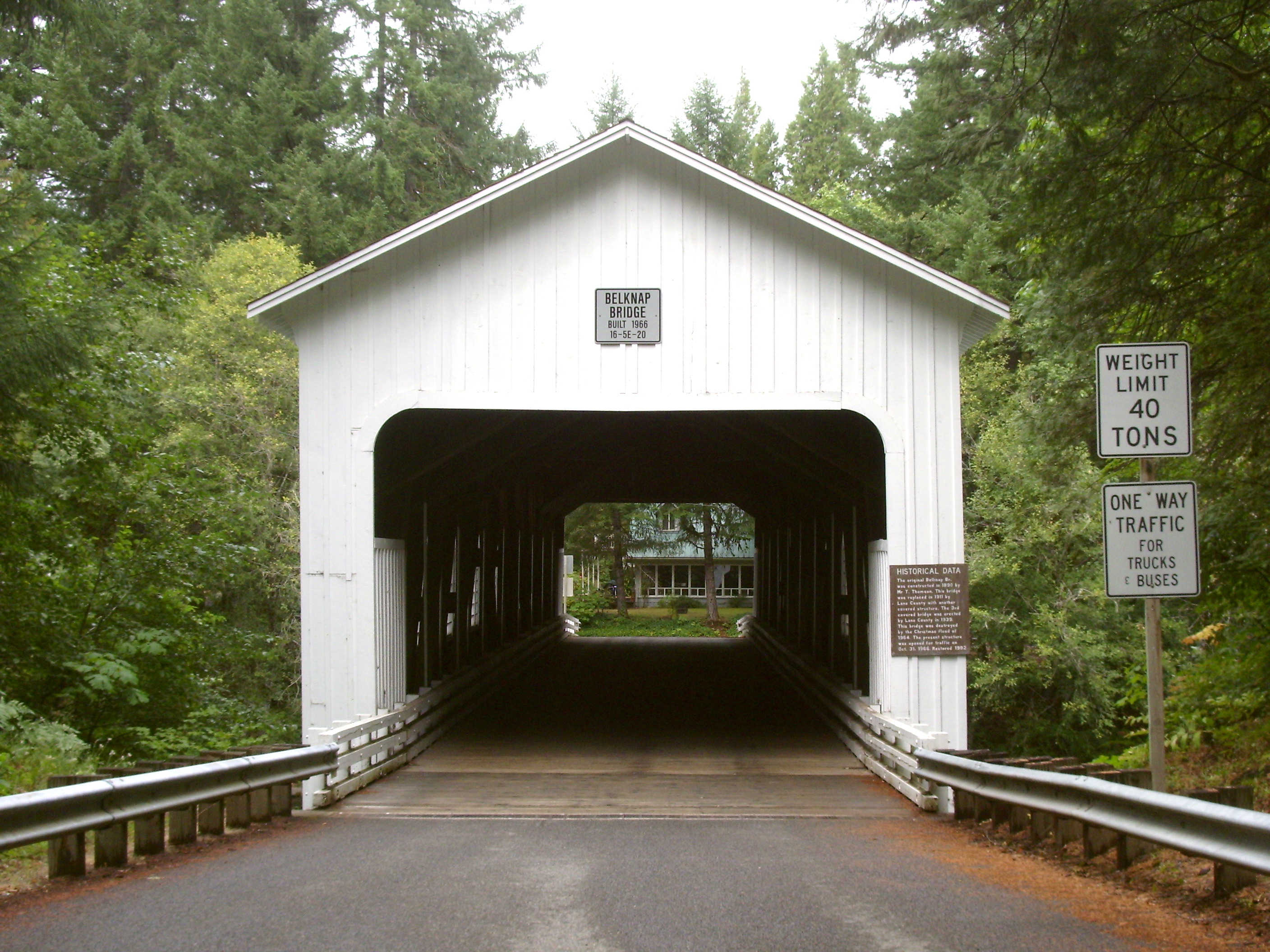
McKenzie River near the unincorporated community of Rainbow in Lane County,Oregon . It is the fourth covered bridge built on that site. The bridge is well maintained and open to traffic. The Belknap Bridge is listed on theNational Register of Historic Places .History
Lane County was the first Oregon county to build covered bridges on a large scale. Today, the county has more surviving covered bridges than any other county west of the
Mississippi River , a total of 17 bridges including 14 that are still open to traffic. There has been a covered bridge at the site of the Belknap Bridge since 1890, though the there have been four different bridge structures.Kletzok, Melinda, [http://www.lanecounty.org/News/News_2005/Release_23423.htm "Goodpasture Bridge Commemorative Coins: Going, Going, Gone"] , Public Information Office, Lane County Government, Eugene, Oregon, 9 December 2005.] [http://www.lanegovonline.com/About/belknap.htm "Belknap Covered Bridge"] , "Lane County, Oregon eGovernment", Eugene, Oregon, 1 September 2008.]The original Belknap Bridge was built in 1890 by Mr. T. Thomson. It was name for a pioneer family that settled in the McKenzie River area. Rollin S. Belknap discovered and developed Belknap Springs approximately 9 miles up stream from the bridge. His son, J.H. Belknap, was involved in promoting a toll road over
McKenzie Pass in the early 1870s. [http://home.comcast.net/~draft10/bridges/belknap.html "Belknap Bridge"] , "Oregon Covered Bridges", Ultimate Draft Writer’s Consortium, 2004.] [ [http://www.belknaphotsprings.com/aboutus.html "An Historical Guide"] , Belknap Hot Springs Lodge and Gardens, Belknap Resort and Hot Springs, McKenzie Bridge, Oregon, 2004]Because bridge traffic weakened the structure over time, Lane County replaced the original bridge in 1911. The second bridge was replaced in 1939; however, that bridge was destroyed in the Christmas flood of 1964. The current bridge was opened in 1966. In 1975, louvered windows were added to the south side of the structure to improve the bridge’s interior lighting. The bridge structure was strengthened and the exterior repaired in 1992. In 2002, a new roof was installed as part of a general bridge renovation project. [http://egov.oregon.gov/ODOT/HWY/BRIDGE/docs/covbrdg/Descriptions/belknap.pdf "McKenzie River (Belknap) Covered Bridge"] , "A Guide to Oregon Covered Bridges", Oregon Department of Transportation, State of Oregon, Salem, Oregon, July 2003]
Because of it’s unique scenic beauty and its importance to Oregon’s transportation history, the Belknap Bridge was listed on the National Register of Historic Places in 1979. [ [http://www.nationalregisterofhistoricplaces.com/OR/Lane/state.html "Belknap Bridge"] , National Register of Historic Places, "www.nationalregisterofhistoricalplaces.com", 26 August 2008.] Today, Lane County’s Engineering Division maintains the covered bridges that are open to traffic including the Belknap Bridge.
Structure
The Belknap Bridge is also known as McKenzie River Bridge. It crosses the McKenzie River at the unincorporated community of Rainbow approximately three mile west of the town of
McKenzie Bridge, Oregon which is named after the bridge. The current Belknap Bridge was designed for Lane County by the Oregon Bridge Corporation ofSpringfield, Oregon . [Session, David, [http://www.worldisround.com/articles/17287/photo16.html "Belknap Covered Bridge"] , Worldisround, "www.worldisround.com", 2008.]The Belknap Bridge was designed as a classic covered bridge. It is 120 feet long. The bridge is a single span supported by a
Howe truss system. It has a maximum carrying capacity of 39 tons to accommodate logging trucks. The bridge rests on two concrete foundation tiers. Its wooden floor planks and shingled roof are in good condition, as is theweatherboard housing that protects the Howe truss infrastructure from the weather. [ [http://www.archiplanet.org/wiki/Belknap_Bridge "Belknap Bridge"] , Archiplanet, "www.archiplanet.org", 5 December 2006.]Most of Oregon’s covered bridges including the Belknap Bridge were built using the Howe truss system, developed in 1840 by the
Massachusetts architect William Howe. The system uses heavy timbers reinforced with iron or steel rods. The trusses have central beams and crossed timbers with adjustable, vertical iron rods to support the structural load. [Hauser, Susan, [http://query.nytimes.com/gst/fullpage.html?res=980CE1D91231F930A15750C0A9659C8B63&sec=travel&spon=&pagewanted=all "Over the River and Through the Bridge"] , "The New York Times", New York, New York, 23 March 2003.]See also
*
List of Oregon covered bridges References
External links
* [http://www.lanegovonline.com/ Lane County, Oregon eGovernment]
* [http://www.covered-bridges.org/ Covered Bridge Society of Oregon]
Wikimedia Foundation. 2010.