- Marine Corps Air Station Cherry Point
-
Coordinates: 34°54′03″N 076°52′51″W / 34.90083°N 76.88083°W
MCAS Cherry Point
Cunningham Field
MCAS Cherry Point insignia 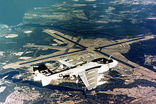
IATA: NKT – ICAO: KNKT – FAA LID: NKT Summary Airport type Military Operator United States Marine Corps Location Havelock, North Carolina Built 1942 In use May 20, 1942 - present Commander Col Philip J. Zimmerman [1] Occupants 2nd Marine Aircraft Wing Elevation AMSL 29 ft / 9 m Website Runways Direction Length Surface ft m 5L/23R 7,553 2,302 Asphalt 5R/23L 8,188 2,496 Asphalt 14L/32R 8,984 2,738 Asphalt 14R/32L 8,399 2,560 Asphalt Sources: Official website[2] and FAA[3] Marine Corps Air Station Cherry Point or MCAS Cherry Point(*34°54′03″N 76°52′51″W / 34.9009°N 76.8807°W) (IATA: NKT, ICAO: KNKT, FAA LID: NKT) is a United States Marine Corps airfield located in Havelock, North Carolina, USA, in the eastern part of the state. It was built in 1941, and was commissioned in 1942 and is currently home to the 2nd Marine Aircraft Wing.
Contents
Resident units
- Headquarters and Headquarters Squadron
- 2nd Marine Aircraft Wing
- Combat Logistics Company 21
- Fleet Readiness Center (East)
MCAS Cherry Point also maintains a satellite field at MCALF Bogue, in Bogue, North Carolina, as well as an outlying airfield at Marine Corps Outlying Field (MCOLF) Atlantic in Atlantic, NC. Several former outlying landing fields have been converted to regional airports, such as MCOF Greenville, MCAA Kinston, and MCOF New Bern.
History
Congress authorized Marine Corps Air Station Cherry Point on July 9, 1941, with an initial appropriation of $14,990,000 for construction and clearing of an 8,000 acre (32 km²) tract of swamps, farms and timberland.
Actual clearing of the site began on August 6, 1941, with extensive drainage and malaria control work. Construction began in November just 17 days before the attack on Pearl Harbor.
On May 20, 1942, the facility was commissioned Cunningham Field, named in honor of the Marine Corps' first aviator, Lieutenant Colonel Alfred A. Cunningham. The completed facility was later renamed Marine Corps Air Station Cherry Point, after a local post office situated among cherry trees.
Cherry Point's primary World War II mission was to train units and individual Marines for service to the Pacific theater. The air station also served as a base for anti-submarine operations, with an Army Air Corps (22d Antisubmarine Squadron) and later a Navy squadron each being responsible for the sinking of a German U-boat just off the North Carolina coast during 1943.
Cherry Point's contribution to the Korean War effort was to provide a steady stream of trained aviators and air crewmen as well as maintenance and support personnel as replacements to forward deployed aviation units.
During the Vietnam War, Cherry Point deployed three A-6 Intruder squadrons to the Far East and again provided a constant source of replacements for aircrews and enlisted aviation personnel.
In Operation Desert Storm, Cherry Point was a major contributor to the victory in Southwest Asia by supporting the deployment of three AV-8B Harrier squadrons, two A-6E Intruder squadrons, one KC-130 Hercules squadron, one EA-6B Prowler squadron, and headquarters detachments from Marine Aircraft Group 14, Marine Aircraft Group 32, and the 2nd Marine Aircraft Wing.
Cherry Point Marines and Sailors participated in strike missions and follow-on operations in Afghanistan and its surrounding region during Operation Enduring Freedom, which was initiated on October 7, 2001.
On September 8, 2007, the headquarters building (198) was gutted by a fire.[4] The groundbreaking ceremony for the new Headquarters Building was on 29 July 2009, with completion planned for sometime in 2011.
The air station and its associated support locations occupy more than 29,000 acres (120 km²). Its runway system is large enough that the air station serves as an alternate emergency landing site for the Space Shuttle launches out of Cape Canaveral, Florida.[5][6]
USAF use
On 1 July 1957 the United States Air Force 614th Airborne Control and Warning Squadron established a Air Defense Command Phase I Mobile Radar station (M-116) at Cherry Point. This station was part of the planned deployment of forty-four Mobile radar stations. The Air Force activated an AN/FPS-6 and two AN/FPS-8 radars located adjacent to Base Flight Operations. These radars were placed on top of 90-foot (27 m) towers without radomes, and initially the station functioned as a Ground-Control Intercept (GCI) and warning station. As a GCI station, the squadron's role was to guide interceptor aircraft toward unidentified intruders picked up on the unit's radar scopes.
In addition to the radars on the air station, two unmanned AN/FPS-14 "Gap Filler" sites, one at Engelhard, NC (M-116B) 35°29′49″N 076°00′34″W / 35.49694°N 76.00944°W and one at Holly Ridge, NC (M-116C) 34°30′50″N 077°32′08″W / 34.51389°N 77.53556°W were set up for additional coverage.
One of the AN/FPS-8s was damaged by Hurricane Donna in 1960. The radars were turned over to the Navy on 30 April 1960, and the Marine Corps retained the other undamaged AN/FPS-8 radar for a number of years for base air traffic control.
During 1961 M-116 joined the Semi Automatic Ground Environment (SAGE) system, initially feeding data to DC-04 at Fort Lee AFS, Virginia. After joining, the squadron was re-designated as the 614th Radar Squadron (SAGE) on 1 March 1963. The radar squadron provided information 24/7 the SAGE Direction Center where it was analyzed to determine range, direction altitude speed and whether or not aircraft were friendly or hostile.
Air Force radar operations continued at MCAS Cherry Point until 1 August 1963 when budget reductions and a general draw-down of antiaircraft radar sites closed the facility.[7][8]
See also
- Marine Corps Auxiliary Landing Field Bogue
- Proposed Outlying Landing Field in North Carolina
- United States Marine Corps Aviation
- List of United States Marine Corps installations
- List of airports in North Carolina
- List of USAF Aerospace Defense Command General Surveillance Radar Stations
References
- Notes
 This article incorporates public domain material from websites or documents of the United States Marine Corps.
- ^ "MCASCPCO". United States Marine Corps. http://www.marines.mil/unit/mcascherrypoint/Pages/command/MCASCPCO.aspx.
- ^ MSAC Cherry Point, official site, retrieved 2007-11-12
- ^ FAA Airport Master Record for NKT (Form 5010 PDF), effective 2007-10-25
- ^ "Headquarters building badly damaged in fire at Cherry Point Marine base". New Bern Sun Journal. September 9, 2007. http://www.newbernsj.com/onset?id=36406&template=article.html. Retrieved 2007-09-10.
- ^ AirStaO 3121.1A MARINE CORPS AIR STATION (MCAS) CHERRY POINT SPACE SHUTTLE SUPPORT PLAN (SSSP)
- ^ Beard, Steven D.; Leslie A. Ringo, Brian Mader, Estela H. Buchmann, and Thomas Tanita. "Space Shuttle Landing and Rollout Training at the Vertical Motion Simulator". American Institute of Aeronautics and Astronautics. http://www.aviationsystemsdivision.arc.nasa.gov/publications/2008/AF2008096.pdf. Retrieved 2 January 2011.
- ^ Winkler, David F. (1997), Searching the skies: the legacy of the United States Cold War defense radar program. Prepared for United States Air Force Headquarters Air Combat Command.
- ^ Radomes information for Cherry Point
- Bibliography
- Shettle Jr., M. L. (2001). United States Marine Corps Air Stations of World War II. Bowersville, Georgia: Schaertel Publishing Co.. ISBN 0-964-33882-3.
- Web
External links
- USMC Life Cherry Point An Insider's Guide to Cherry Point Marine Base
- MCAS Cherry Point at GlobalSecurity.org
- USMC Air Station Cherry Point Overview & PCS Information (MarineCorpsUSA.org)
- FAA Airport Diagram (PDF), effective 20 October 2011
- FAA Terminal Procedures for NKT, effective 20 October 2011
- Resources for this U.S. military airport:
- AirNav airport information for KNKT
- ASN accident history for NKT
- NOAA/NWS latest weather observations
- SkyVector aeronautical chart for KNKT
 USAAF Antisubmarine Command
Command Headquarters Antisubmarine Command · I Bomber Command (First Air Force, 1941–42)Wings 25th Antisubmarine · 26th Antisubmarine
Groups 1st Search Attack · 2d Bombardment · 13th Bombardment · 45th Bombardment · 304th Bombardment · 377th Bombardment · 378th Bombardment · 479th Antisubmarine · 480th Antisubmarine
Squadrons AntisubmarineOther2d Search Attack · 3d Search Attack · 4th Search Attack
Airfields United StatesDover (Delaware) · Drew (Florida) · Jacksonville (Florida) · Key West (Florida) · Lantana (Florida) · Miami (Florida) · Orlando (Florida) · Savannah (Georgia) · Grenier (New Hampshire) · Atlantic City (New Jersey) · Fort Dix (New Jersey) · Mitchel (New York) · Bluethenthal (North Carolina) · Cherry Point (North Carolina) · Charleston (South Carolina) · Hyannis (Massachusetts) · Otis (Massachusetts) · Westover (Massachusetts) · Langley (Virginia)
NewfoundlandCaribbeanEuropeNorth AfricaCurrent military installations of North CarolinaArmy  FortPortAir FieldMackall • SimmonsRange
Marines  Air StationCherry Point • New RiverCampRangeLanding Field
Navy  RangeBrant Island • Dare County • Piney Island • Stumpy Point
Air Force  OtherAir Force Combat Climatology Center
Coast Guard  Cape Hatteras • Fort MaconStationElizabeth City • Emerald Isle • Fort Macon • Hattaras Inlet • Hobucken • Oak Island • Ocracoke • Oregon Inlet • Wrightville BeachSupport CenterElizabeth City
Municipalities and communities of Craven County, North Carolina County seat: New Bern Cities 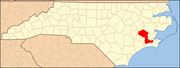
Towns Bridgeton | Cove City | Dover | River Bend | Trent Woods | Vanceboro
CDPs Military base Cherry Point Air Station
Categories:- Populated places in Craven County, North Carolina
- Military facilities in North Carolina
- Space Shuttle landing sites
- United States Marine Corps air stations
- World War II airfields
- Military Superfund sites
- Populated places established in 1941
- Radar stations of the United States Air Force


Wikimedia Foundation. 2010.