- Chihuahuan Desert Research Institute
-
The Chihuahuan Desert Research Institute or CDRI, incorporated in January 1974, is an independent non-profit, scientific and educational organization located on a 507-acre (2.05 km2) tract in the foothills of the Davis Mountains. The organization's stated goal is to promote public awareness, appreciation, and concern for the natural diversity of the Chihuahuan Desert region through research and education. With its roots in nearby Sul Ross State University, the institute also works closely with several other colleges, universities, and organizations. Dr. Cathryn Hoyt is the executive director and has held that position since 2004.
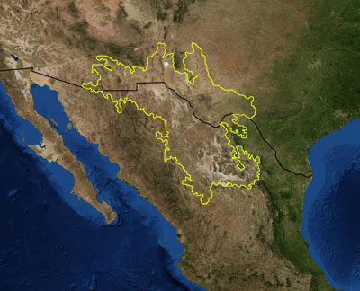
 Map of the Chihuahuan Desert. Satellite image from NASA. Ecoregion boundary based on World Wide Fund for Nature ecoregions. The US-Mexico border is shown as a black line.
Contents
History
From 1974 to 1983, the Institute was housed in the Centennial School Building in Alpine, Texas. The Alpine Independent School District generously leased the facility to CDRI at the rate of $1.00 per year.
In 1983, Centennial School was sold and the CDRI moved to Honors Hall on the campus of Sul Ross State University. While headquartered on the Sul Ross State University campus, the Institute conducted its activities from Honors Hall (1983-1991), and later from the Barton Warnock Science Building (1991-1997).
Education and Outreach
CDRI publishes a magazine, The Chihuahuan Desert Discovery twice a year which is distributed to its members. Another way in which the CDRI staff inform the public about their efforts is by writing a weekly radio program, "Nature Notes", which airs Thursday mornings on KRTS, the National Public Radio affiliate in Marfa, Texas.
To extend its goal of research and education to the geology of the Desert, CDRI intends to install a geological pavilion on the highest point of the Institute’s site. This will allow for the disassembly of the 360° panorama presented by its mountain top location into eight individual views and provides a focal point for their re-assembly and integration as a visual representation, study, and explanation of the geology which controls that panorama. Displays will first focus on the immediate area, where three igneous cored domes (diameters: 3 – 4 km) and other associated intrusions, including the igneous stock on which the pavilion itself sits, are well exposed. These domes are thought to be cored by laccoliths. The topography of the domes is variable, as is the degree of exposure of the actual intrusions; in fact, the only exposure of the intrusion coring one of the domes is on a fault located along its north edge (trap door laccolith?). The thrust of the display will be to relate the view of the domes from the pavilion to the view presented in maps and cross sections, as well as the view presented by satellite images. Other displays at the pavilion will take advantage of broader views of the Davis Mountains. For example, in the core of another of these domes, the contact of the Crossen Trachyte, a major mapping unit in the south of the range, and the Star Mountain Formation, another mapping unit but in the north of the range, can be seen. This is the only location in the whole of the range where their contact can be mapped. The Crossen extends to Crossen Mesa, 64 km to the south; the Star Mountain 50 km to the north. As seen from the pavilion, it is dramatically exposed in the cliffs of Star Mountain, 27 km away.
Land Acquisition
In 1978, CDRI purchased the 507-acre (2.05 km2) tract. This site is being developed as a research and educational facility where visitors can experience the Chihuahuan Desert firsthand. In 1985, the land was fully paid for through public contributions. With the construction of its new Visitors' Center in January, 1998, the CDRI moved operations from the Sul Ross campus to its permanent home near Fort Davis where it has been open to the public year-round ever since.
Funding
CDRI operations are funded through tax-deductible contributions, professional services, annual and life memberships, the proceeds from special events, and short and long-term investments. Clayton Williams, a founding member of CDRI has donated a considerable amount of money to the institute. A significant bequest from the estate of renowned biologist Roger Conant in 2005 helped put the organization on a firm financial position.
See also
Chihuahuan Desert Nature Center and Botanical Gardens
References
- Chihuahuan Desert Research Institute
- Sibley Nature Center (Midland Texas) Essay on CDRI
- Lady Bird Johnson Wildflower Center at the University of Texas at Austin
- CDRI Geological Society of America grant proposal
External links
Categories:- Independent research institutes
- Chihuahuan Desert
- Protected areas of Jeff Davis County, Texas
- Protected areas of Texas
Wikimedia Foundation. 2010.