- Washington State Route 14
-
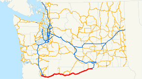
State Route 14
Route information Defined by RCW 47.17.060 Maintained by WSDOT Length: 180.68 mi[1] (290.78 km) Existed: 1968 – present Major junctions West end:  I-5 in Vancouver
 I-205 in Vancouver
 SR 500 in Camas
 SR 141 in Bingen
 SR 142 in Lyle
 US 197 near Dallesport
 US 97 in Maryhill
 SR 221 in Paterson
East end: 
 I-82/US 395 in Plymouth
Highway system State highways in Washington
Interstate • US • State
Former PSH • 1964 renumbering • Former SR←  US 12
US 12SR 16  →
→State Route 14, also called the Lewis and Clark Highway, is a state highway in Washington. It extends for approximately 180 miles (290 km) from a junction with Interstate 5 in Vancouver in the west, to a junction with Interstate 82 and U.S. Route 395 in the east; just across the state line from Umatilla, Oregon, and south of Kennewick.
Contents
Route description
State Route 14 originates in downtown Vancouver at a junction with Interstate 5 just north of the Interstate Bridge. It proceeds east as a freeway for approximately 18 miles (29 km) until it reaches the city of Camas, at which point it becomes a two-lane road. It then continues east along the north bank of the Columbia River (through the Columbia River Gorge) for the remainder of its journey.
Other than the stretch of freeway in Clark County, SR 14 is a two-lane highway which often runs along steep bluffs as high as 800 feet (240 m) through the Columbia Gorge, where frequent high winds can be a driving hazard. At the town of Lyle the forest scenery gives way to arid grasslands in a remarkably rapid transition.
History
The stretch of SR 14 between Vancouver and Maryhill was formerly designated as U.S. Route 830. The section east of Maryhill was formerly designated as State Route 12.
In 1967, U.S. Route 12 was extended from Lewiston, Idaho, into Washington state along what had been State Route 14 from near Centralia to Naches. At that point, what had been State Route 12 was redesignated State Route 14.
In 1968, U.S. Route 830 was dropped from the U.S. Highway System, and State Route 14 was extended west to Vancouver.
Prior to the 1964 renumbering, current State Route 14 from Vancouver to Maryhill had been a part of Primary State Highway 8, and east of Maryhill was the Maryhill-Kennewick branch of PSH 8. Former State Route 14 from Centralia to Naches was part of Primary State Highway 5.
Major intersections
County Location Mile[1] # Destinations Notes Clark Vancouver 0.00  I-5 south – Portland
Westbound exit and eastbound entrance 0.00 C Street, 8th Street-Vancouver City Center Westbound exit and eastbound entrance 0.00 I-5 north – SeattleWestbound exit and eastbound entrance 1.04 1 Southeast Columbia Way – Vancouver National Historic Reserve 3.00 3 Evergreen Boulevard, Riverside Drive 4.36 4 Lieser Road, Southeast 88th Avenue 5.58 5 Southeast Ellsworth Road Eastbound exit and westbound entrance 6.09 6 
 I-205 to I-84 – Seattle, Northeast Portland, Salem
8.53 8 Southeast 164th Avenue 10.10 10 Southeast 192nd Avenue East end of freeway Camas 12.33 12 
 SR 14 Bus. east (Sixth Avenue) / Norwood Street – Camas
Interchange 14.64 SR 500 westWashougal 16.11 15th Street – Washougal Former SR 140 18.90
SR 14 Bus. west (Evergreen Boulevard) – WashougalSkamania 26.20 Canyon Creek Road Former SR 140 41.48 Bridge of the Gods – Cascade Locks Klickitat 63.45 
SR 141 Spur – Trout LakeWhite Salmon 64.99 Hood River Bridge – Hood River Bingen 66.32 SR 141 north – White Salmon, Trout LakeLyle 75.78 SR 142 east – Klickitat, Goldendale83.44 US 197 south – The Dalles100.93 US 97 north – Goldendale, YakimaWest end of US 97 overlap 101.35 US 97 south to I-84 – BendEast end of US 97 overlap Benton Paterson 167.16 SR 221 north – Prosser179.87 Plymouth Road – Plymouth Former SR 143 180.68  I-82 (US 395) – Kennewick, Umatilla, Pendleton
Interchange References
External links
State highways in Washington related to SR 14 
Freeways in the Portland, Oregon Metropolitan Area Radial Circumferential Bridges Categories:- State highways in Washington (state)
- Columbia River Gorge
- Transportation in Clark County, Washington
- Transportation in Skamania County, Washington
- Transportation in Klickitat County, Washington
- Transportation in Benton County, Washington
- Scenic highways in Washington (state)


Wikimedia Foundation. 2010.