- National Register of Historic Places listings in Pima County, Arizona
-
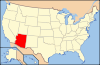
 Location of Pima County in Arizona
This is a list of the National Register of Historic Places listings in Pima County, Arizona.
This is intended to be a complete list of the properties and districts on the National Register of Historic Places in Pima County, Arizona, United States. The locations of National Register properties and districts for which the latitude and longitude coordinates are included below, may be seen in a Google map.[1]
There are 163 properties and districts listed on the National Register in the county, including 4 that are also National Historic Landmarks.
-
- This National Park Service list is complete through NPS recent listings posted November 10, 2011.[2]
Current listings
[3] Landmark name Image Date listed Location City or town Summary 1 James P. and Sarah Adams House August 30, 2011 5201 N. Camino Escuela
32°18′05″N 110°56′08″W / 32.301389°N 110.935556°WTucson Architecture and Planning of Josias Joesler and John Murphey in Tucson, AZ MPS 2 Agua Caliente Ranch Rural Historic Landscape July 9, 2009 12325 E. Roger Rd.
32°16′54″N 110°44′00″W / 32.281667°N 110.733333°WTucson 3 Air Force Facility Missile Site 8 (571-7) Military Reservation 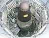
December 3, 1992 1580 W. Duval Mine Rd.
31°54′11″N 110°59′54″W / 31.903056°N 110.998333°WGreen Valley Titan Missile Museum 4 Ajo Townsite Historic District 
November 30, 2001 Blocks 1 through 31
32°22′20″N 112°51′48″W / 32.372222°N 112.863333°WAjo 5 Aldea Linda Residential Historic District June 9, 2009 4700-5000 blocks of E. Calle Jabali, E. 22nd St., and the 1100 block of S. Swan Rd.
32°12′34″N 110°53′20″W / 32.209311°N 110.888769°WTucson 6 Arizona Daily Star Building February 22, 2002 30 N. Church Ave.
32°13′26″N 110°58′20″W / 32.223889°N 110.972222°WTucson 7 Arizona Hotel September 12, 2003 31-47 N. 6th Ave., 135 E. 10th St.
32°13′27″N 110°58′07″W / 32.224167°N 110.968611°WTucson 8 Arizona Inn 
April 5, 1988 2200 E. Elm St.
32°14′31″N 110°56′19″W / 32.241944°N 110.938611°WTucson Historic hotel 9 Armory Park Historic Residential District 
July 30, 1976 E. 12th St. to 19th St., Stone Ave. to 2nd Ave.; also roughly 19th, 20th, and 21st Sts. from Stone Ave. to Jacobs Ave.
32°12′56″N 110°57′58″W / 32.215556°N 110.966111°WTucson Second set of addresses represents a boundary increase 10 Barrio Anita September 23, 2011 Roughly bounded by W. Speedway Blvd., Union Pacific Railroad, N. Granada Ave., St. Mary's Rd. & I-10
32°13′59″N 110°58′47″W / 32.233056°N 110.979722°WTucson 11 Barrio El Hoyo Historic District August 13, 2008 Roughly bounded by W. Cushing St. on the north, W. 18th St. on the south, S. 11th Ave. on the east, and S. Samaniego Ave. on the west
32°12′53″N 110°58′30″W / 32.214725°N 110.974944°WTucson 12 Barrio El Membrillo Historic District August 5, 2009 Bounded by W. Granada St. on the north, W. Simpson St. on the south, and the right-of-way of the former El Paso and Southwestern railroad line on the east
32°12′58″N 110°58′42″W / 32.216103°N 110.978422°WTucson 13 Barrio Libre October 18, 1978 Roughly bounded by 14th, 19th, Stone and Osborne Sts.
32°12′46″N 110°58′23″W / 32.212778°N 110.973056°WTucson 14 Barrio Santa Rosa September 23, 2011 Roughly bounded by W. 18th St., S. Russell Ave., W. 22nd St., S. 9th Ave., & S. Meyer Ave.
32°12′34″N 110°58′15″W / 32.209444°N 110.970833°WTucson 15 Bates Well Ranch 
May 20, 1994 Eastern side of Bates Well Rd.
32°10′06″N 112°57′01″W / 32.168333°N 112.950278°WAjo 16 Binghampton Rural Historic Landscape May 1, 2003 Approximately at the junction of N. Dodge Boulevard and E. River Rd.
32°16′45″N 110°55′01″W / 32.279167°N 110.916944°WTucson 17 Blenman-Elm Historic District October 29, 2003 Bounded by Grant, Country Club, Speedway, and Campbell
32°14′38″N 110°56′00″W / 32.243889°N 110.933333°WTucson 18 Blixt-Avitia House March 30, 1992 830 W. Alameda St.
32°13′22″N 110°59′06″W / 32.222778°N 110.985°WTucson 19 Boudreaux-Robison House March 30, 1992 101 N. Bella Vista Dr.
32°13′16″N 110°59′33″W / 32.221111°N 110.9925°WTucson 20 Bray-Valenzuela House March 30, 1992 203 N. Grande Ave.
32°13′25″N 110°59′18″W / 32.223611°N 110.988333°WTucson 21 Bull Pasture September 1, 1978 East of Lukeville in the Organ Pipe Cactus National Monument
32°00′49″N 112°41′42″W / 32.013611°N 112.695°WLukeville 22 Erskine P. Caldwell House September 9, 2010 1915 E. Camino Miraval
32°18′28″N 110°56′29″W / 32.307778°N 110.941389°WTucson Architecture and Planning of Josias Joesler and John Murphey in Tucson, AZ MPS 23 Dr. William Austin Cannon House October 25, 1982 1189 E. Speedway
32°14′10″N 110°57′13″W / 32.236111°N 110.953611°WTucson 24 Canoa Ranch Headquarters Historic District May 30, 2007 5555 S. State Route 19
32°14′10″N 110°57′13″W / 32.236111°N 110.953611°WGreen Valley 25 Catalina Vista Historic District October 29, 2003 Bounded by Grant, Tucson Boulevard, Elm St., and Campbell Ave.
32°14′53″N 110°56′23″W / 32.248056°N 110.939722°WTucson 26 Catalina American Baptist Church May 23, 2008 1900 N. Country Club Rd.
32°14′42″N 110°55′36″W / 32.24507°N 110.9268°WTucson 27 Cavalry Corrals December 13, 1978 N. Craycroft Boulevard
32°15′29″N 110°52′28″W / 32.258056°N 110.874444°WTucson 28 Cienega Bridge 
September 30, 1988 5.3 miles southeast of Vail on Marsh Station Rd.
32°01′11″N 110°38′43″W / 32.019722°N 110.645278°WVail 29 Cocoraque Butte Archeological District October 10, 1975 Address Restricted Tucson 30 Colonia Solana Residential Historic District January 4, 1989 Roughly bounded by Broadway Boulevard, S. Randolph Way, Camino Campestre, and S. Country Club
32°13′03″N 110°55′18″W / 32.2175°N 110.921667°WTucson 31 Colossal Cave Preservation Park Historic District July 10, 1992 Junction of Old Spanish Trail and Colossal Cave Rd.
32°03′25″N 110°38′11″W / 32.056944°N 110.636389°WVail 32 Copper Bell Bed and Breakfast March 30, 1992 25 N. Westmoreland Ave.
32°13′16″N 110°59′33″W / 32.221111°N 110.9925°WTucson 33 John P. and Helena S. Corcoran House August 30, 2011 2200 E. Calle Lustre
32°18′18″N 110°56′28″W / 32.305°N 110.941111°WTucson Architecture and Planning of Josias Joesler and John Murphey in Tucson, AZ MPS 34 Cordova House May 4, 1972 173-177 N. Meyer Ave.
32°13′25″N 110°58′27″W / 32.223611°N 110.974167°WTucson 35 Coronado Hotel 
November 30, 1982 410 E. 9th St.
32°13′25″N 110°57′52″W / 32.223611°N 110.964444°WTucson 36 Curley School January 31, 2008 201 W. Esperanza Ave.
32°22′20″N 112°51′50″W / 32.372211°N 112.863769°WAjo 37 Deep Well Ranch October 1, 2004 13001 E. Redington Rd.
32°15′24″N 110°42′53″W / 32.256667°N 110.714722°WTucson 38 DeGrazia Gallery in the Sun Historic District 
October 12, 2006 6300 N. Swan Rd.
32°19′47″N 110°53′30″W / 32.329722°N 110.891667°WTucson Ettore DeGrazia's studio and home 39 Desert Laboratory 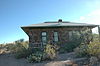
October 15, 1966 West of Tucson off W. Anklam Rd. on Tumamoc Hill
32°12′59″N 111°00′33″W / 32.216389°N 111.009167°WTucson 40 Dodson-Esquivel House March 30, 1992 1004 W. Alameda St.
32°13′53″N 110°59′18″W / 32.231389°N 110.988333°WTucson 41 Don Martin Apartment House September 9, 2010 605 E. 9th St.
32°13′27″N 110°57′44″W / 32.224167°N 110.962222°WTucson Architecture and Planning of Josias Joesler and John Murphey in Tucson, AZ MPS 42 Dos Lomitas Ranch 
May 6, 1994 Organ Pipe Cactus National Monument
31°51′29″N 112°44′25″W / 31.858056°N 112.740278°WAjo 43 El Camino Del Diablo 
December 1, 1978 Northwest of Lukeville
32°04′20″N 113°23′12″W / 32.072222°N 113.386667°WLukeville 44 El Conquistador Water Tower June 20, 1980 Broadway and Randolph Way
32°13′13″N 110°55′07″W / 32.220278°N 110.918611°WTucson 45 El Encanto Apartments December 30, 1994 2820 E. 6th St.
32°13′30″N 110°55′22″W / 32.225°N 110.922778°WTucson 46 El Encanto Estates Residential Historic District January 29, 1988 Roughly bounded by Country Club Rd., Broadway Boulevard, 5th St., and Jones St.
32°13′30″N 110°55′22″W / 32.225°N 110.922778°WTucson 47 El Montevideo Historic District September 12, 1994 3700 and 3800 blocks of streets between Broadway and 5th St.; also 3700 and 3800 blocks of Camino Del Norte
32°13′31″N 110°54′37″W / 32.225278°N 110.910278°WTucson Second set of addresses represents a boundary increase 48 El Paso and Southwestern Railroad Depot March 12, 2004 419 W. Congress St.
32°13′53″N 110°58′39″W / 32.231389°N 110.9775°WTucson 49 El Presidio Historic District September 27, 1976 Roughly bounded by W. 6th and W. Alameda Sts. and N. Stone and Granada Aves.
32°13′30″N 110°58′30″W / 32.225°N 110.975°WTucson 50 El Tiradito November 19, 1971 221 S. Main St.
32°12′53″N 110°58′39″W / 32.214722°N 110.9775°WTucson 51 The Eleven Arches September 9, 2010 5201 N. Hacienda Del Sol
32°17′47″N 110°55′10″W / 32.296389°N 110.919444°WTucson Architecture and Planning of Josias Joesler and John Murphey in Tucson, AZ MPS 52 Empire Ranch 
May 30, 1975 6 miles east of Greaterville
31°47′07″N 110°38′33″W / 31.785278°N 110.6425°WGreaterville Centerpiece of Las Cienegas National Conservation Area 53 Empirita Cattle Ranch Rural Historic District January 8, 2009 Between Vail and Benson, south of Interstate 10 Benson 54 Feldman's Historic District September 21, 1989 Roughly bounded by Lee St., Park Ave., Speedway Boulevard, 7th Ave., Drachman St., and 2nd Ave.; also generally north of E. Speedway Boulevard, west of N. Park Ave., south of E. Lee St., and east of N. 7th St.
32°14′18″N 110°57′45″W / 32.238333°N 110.9625°WTucson Name changed from Speedway-Drachman Historic District.[4] Second set of addresses represents a boundary increase 55 First Hittinger Block September 12, 2003 116 E. Congress St.
32°13′25″N 110°58′09″W / 32.223611°N 110.969167°WTucson 56 First Joesler House September 9, 2010 3408 E. Fairmount St.
32°14′22″N 110°55′11″W / 32.239444°N 110.919722°WTucson Architecture and Planning of Josias Joesler and John Murphey in Tucson, AZ MPS 57 P.W. Fletcher House August 30, 2011 4850 N. Campbell Ave.
32°17′46″N 110°56′23″W / 32.296111°N 110.939722°WTucson Architecture and Planning of Josias Joesler and John Murphey in Tucson, AZ MPS 58 Fort Lowell Park December 13, 1978 N. Craycroft Boulevard
32°15′37″N 110°52′29″W / 32.260236°N 110.874675°WTucson 59 Fourth Avenue Underpass September 30, 1988 4th Ave.
32°13′22″N 110°57′54″W / 32.222778°N 110.965°WTucson 60 Fox Commercial Building April 6, 2004 27 W. Congress St.
32°13′25″N 110°58′18″W / 32.223611°N 110.971667°WTucson 61 Fox Theatre 
September 12, 2003 17 W. Congress St.
32°13′25″N 110°58′18″W / 32.223611°N 110.971667°WTucson 62 Gabel House September 9, 2010 5445 N. Camino Escuela
32°18′20″N 110°55′57″W / 32.305556°N 110.9325°WTucson Architecture and Planning of Josias Joesler and John Murphey in Tucson, AZ MPS 63 Gachado Well and Line Camp 
November 2, 1978 East of Lukeville in the Organ Pipe Cactus National Monument
31°52′18″N 112°47′08″W / 31.871667°N 112.785556°WLukeville 64 Gist Residence December 4, 2009 5626 E. Burns St.
32°13′27″N 110°52′21″W / 32.2241°N 110.872392°WTucson 65 John and Isabella Greenway House February 23, 1998 1 Greenway House Dr.
32°21′59″N 112°52′09″W / 32.366389°N 112.869167°WAjo 66 Growler Mine Area November 14, 1978 North of Lukeville
32°10′10″N 112°58′05″W / 32.169444°N 112.968056°WLukeville 67 Gunsight Mountain Archeological District June 21, 1991 Address Restricted Three Points 68 Arthur C. and Helen Neel Hall House August 30, 2011 4875 N. Campbell Ave.
32°17′43″N 110°56′27″W / 32.295278°N 110.940833°WTucson Architecture and Planning of Josias Joesler and John Murphey in Tucson, AZ MPS 69 Lewis D.W. Hall House August 30, 2011 3160 E. Via Celeste
32°18′09″N 110°55′30″W / 32.3025°N 110.925°WTucson Architecture and Planning of Josias Joesler and John Murphey in Tucson, AZ MPS 70 Haynes Building September 9, 2010 312-314 E. Sixth St.
32°13′40″N 110°58′00″W / 32.227778°N 110.966667°WTucson Architecture and Planning of Josias Joesler and John Murphey in Tucson, AZ MPS 71 Hecker House September 9, 2010 2635 N. Camino Principal
32°15′21″N 110°51′06″W / 32.255833°N 110.851667°WTucson Architecture and Planning of Josias Joesler and John Murphey in Tucson, AZ MPS 72 Hotel Congress 
September 12, 2003 303-311 E. Congress St.
32°13′27″N 110°58′00″W / 32.224167°N 110.966667°WTucson Historic hotel 73 Sam Hughes Neighborhood Historic District September 29, 1994 Roughly bounded by E. Speedway Boulevard, N. Campbell Ave., E. 7th St., and N. Bentley Ave.
32°13′57″N 110°56′10″W / 32.2325°N 110.936111°WTucson Represents a boundary increase of the El Encanto Estates Residential Historic District 74 I'itoi Mo'o-Montezuma's Head and 'Oks Daha-Old Woman Sitting May 2, 1994 Organ Pipe Cactus National Monument
32°07′02″N 112°42′19″W / 32.117222°N 112.705278°WAjo 75 Indian House Community Residential Historic District October 28, 2001 Roughly bounded by 5th St., E. Wash, Kane Estates, and Sahura St.
32°13′41″N 110°51′52″W / 32.228056°N 110.864444°WTucson 76 Indian Ridge Historic District July 16, 2010 NW of Sabino Canyon and Tanque Verde
Tucson 77 Iron Horse Expansion Historic District June 19, 1986 Roughly bounded by 8th St., Euclid Ave., Hughes, and 10th Sts., and N. 4th and Hoff Aves.
32°13′25″N 110°57′42″W / 32.223611°N 110.961667°WTucson 78 J. C. Penney-Chicago Store September 12, 2003 130 E. Congress St.
32°13′25″N 110°58′07″W / 32.223611°N 110.968611°WTucson 79 Julian-Drew Building March 29, 1996 182 E. Broadway
32°13′15″N 110°57′57″W / 32.220833°N 110.965833°WTucson 80 Kentucky Camp Historic District 
November 22, 1995 Address Restricted Sonoita Ghost town and former mining camp 81 Lemmon Rock Lookout House January 28, 1988 Coronado National Forest
32°26′06″N 110°47′20″W / 32.435°N 110.788889°WTucson Historic fire lookout 82 Los Robles Archeological District May 11, 1989 Address Restricted Red Rock[disambiguation needed  ]
]83 Lowell Ranger Station June 10, 1993 Off Sabino Canyon Rd. northeast of Tucson in the Coronado National Forest
32°18′39″N 110°49′04″W / 32.310833°N 110.817778°WTucson 84 Manning Cabin 
March 31, 1975 10 miles east of Tucson in the Saquaro National Monument
32°12′27″N 110°33′09″W / 32.2075°N 110.5525°WTucson 85 Levi H. Manning House July 27, 1979 9 Paseo Redondo
32°13′23″N 110°58′42″W / 32.223056°N 110.978333°WTucson 86 Marist College Historic District October 25, 2011 72 W. Ochoa St.
32°13′14″N 110°58′19″W / 32.220556°N 110.971944°WTucson 87 Antonio Matus House and Property July 22, 1991 856 W. Calle Santa Ana
32°14′53″N 110°59′07″W / 32.248056°N 110.985278°WTucson 88 Phillip G. McFadden House August 30, 2011 5130 Camino Real
32°18′00″N 110°56′02″W / 32.3°N 110.933889°WTucson Architecture and Planning of Josias Joesler and John Murphey in Tucson, AZ MPS 89 Men's Gymnasium, University of Arizona 
October 4, 1990 E. 4th St., University of Arizona campus
32°13′51″N 110°56′58″W / 32.230833°N 110.949444°WTucson Bear Down Gym 90 Menlo Park Historic District April 23, 2010 13 Subdivisions irregularly bounded around Grande Ave. and W. Congress St. intersection
32°13′12″N 110°59′18″W / 32.220022°N 110.988456°WTucson 91 Milton Mine September 1, 1978 Northwest of Lukeville
31°58′08″N 112°53′20″W / 31.968889°N 112.888889°WLukeville 92 Officer's Quarters 
December 13, 1978 N. Craycroft Boulevard
32°15′29″N 110°52′28″W / 32.258056°N 110.874444°WTucson Includes Commanding Officer's quarters (photo, now restored) at old Fort Lowell 93 Old Adobe Patio June 3, 1971 40 W. Broadway
32°13′14″N 110°58′15″W / 32.220556°N 110.970833°WTucson 94 Old Library Building 
November 28, 1979 University of Arizona campus
32°13′56″N 110°57′18″W / 32.232222°N 110.955°WTucson Now Arizona State Museum, north building 95 Old Main, University of Arizona 
April 13, 1972 University of Arizona campus
32°13′55″N 110°57′10″W / 32.231944°N 110.952778°WTucson 96 Pascua Cultural Plaza September 22, 2004 785 W. Sahuaro St.
32°15′04″N 110°59′05″W / 32.251111°N 110.984722°WTucson 97 Pie Allen Historic District June 20, 1996 Roughly bounded by N. Euclid Ave., E. 6th St., N. Park Ave., and E. 10th St.
32°13′31″N 110°57′21″W / 32.225278°N 110.955833°WTucson 98 Pima County Courthouse 
June 23, 1978 115 N. Church St.
32°13′23″N 110°58′21″W / 32.223056°N 110.9725°WTucson 99 Post Trader's Store and Riallito House December 13, 1978 5425 E. Fort Lowell Rd.
32°15′38″N 110°52′37″W / 32.260556°N 110.876944°WTucson 100 Post Trader's Storehouse December 13, 1978 5354 E. Fort Lowell Rd.
32°15′40″N 110°52′41″W / 32.260997°N 110.87805°WTucson 101 Quartermaster Storehouse December 13, 1978 5479 E. Fort Lowell Rd.
32°15′44″N 110°52′33″W / 32.262222°N 110.875833°WTucson 102 Quartermaster's Corrals December 13, 1978 N. Craycroft Rd. Tucson 103 Ramada House September 24, 2006 2801 E Camino Norberto
32°18′25″N 110°55′48″W / 32.306944°N 110.93°WTucson 104 Rebeil Block March 12, 2004 72 E. Congress
32°13′25″N 110°58′12″W / 32.223611°N 110.97°WTucson 105 Rialto Building September 12, 2003 300-320 E. Congress St.
32°13′25″N 110°58′00″W / 32.223611°N 110.966667°WTucson 106 Rialto Theatre September 12, 2003 318 E. Congress St.
32°13′25″N 110°58′00″W / 32.223611°N 110.966667°WTucson 107 Rillito Racetrack-Chute June 12, 1986 4502 N. 1st Ave.
32°17′23″N 110°57′24″W / 32.289722°N 110.956667°WTucson 108 Rincon Mountain Foothills Archeological District October 16, 1979 Address Restricted Tucson 109 Robles Ranch House September 3, 2010 16130 West Ajo Highway
32°04′43″N 111°18′36″W / 32.078611°N 111.31°WRobles Junction vicinity 110 Ronstadt House February 26, 1979 607 N. 6th Ave.
32°13′45″N 110°58′05″W / 32.229167°N 110.968056°WTucson 111 Ronstadt-Sims Adobe Warehouse May 11, 1989 911 N. 13th Ave.
32°13′27″N 110°58′44″W / 32.224167°N 110.978889°WTucson 112 Sabedra-Huerta House November 10, 1988 1036-1038 N. 13th Ave.
32°14′06″N 110°58′43″W / 32.235°N 110.978611°WTucson 113 St. Philip's in the Hills Episcopal Church December 17, 2004 4440 N. Campbell Ave.
32°17′22″N 110°56′36″W / 32.289444°N 110.943333°WTucson 114 San Clemente Historic District February 4, 2005 Southeastern corner of the intersection of Alvernon and Broadway
32°13′14″N 110°54′18″W / 32.220556°N 110.905°WTucson 115 San Pedro Chapel April 28, 1993 5230 E. Ft. Lowell Rd.
32°15′40″N 110°52′47″W / 32.261111°N 110.879722°WTucson 116 San Xavier del Bac 
October 15, 1966 9 miles south of Tucson via Mission Rd.
32°06′24″N 111°00′22″W / 32.106667°N 111.006111°WTucson 117 Santa Ana del Chiquiburitac Mission Site September 18, 1975 Address Restricted Tucson 118 Santa Cruz Catholic Church October 7, 1994 1220 S. 6th Ave.
32°12′23″N 110°58′06″W / 32.206389°N 110.968333°WTucson 119 Schwalen-Gomez House March 30, 1992 217 N. Melwood Ave.
32°13′29″N 110°59′13″W / 32.224722°N 110.986944°WTucson 120 Site No. HD 4-8A December 13, 1978 E. Fort Lowell Rd.
32°15′43″N 110°52′39″W / 32.261944°N 110.8775°WTucson 121 Site No. HD 5-26 December 13, 1978 5495 E. Fort Lowell Rd.
32°15′44″N 110°52′33″W / 32.262222°N 110.875833°WTucson 122 Site Nos. HD 5-28/5-25 December 13, 1978 3031 N. Craycroft Boulevard
32°15′47″N 110°52′32″W / 32.263056°N 110.875556°WTucson 123 Site No. HD 7-0A December 13, 1978 5429 E. Fort Lowell Rd.
32°15′44″N 110°52′33″W / 32.262222°N 110.875833°WTucson 124 Site No. HD 7-13 December 13, 1978 5531 E. Fort Lowell Rd.
32°15′43″N 110°52′28″W / 32.262008°N 110.874539°WTucson 125 Site Nos. HD 9-11/9-2 December 13, 1978 5651 E. Fort Lowell Rd.
32°15′48″N 110°52′21″W / 32.263333°N 110.8725°WTucson 126 Site No. HD 9-28 December 13, 1978 5668 E. Fort Lowell Rd.
32°15′42″N 110°52′14″W / 32.261667°N 110.870556°WTucson 127 Site Nos. HD 12-4/12-8 December 13, 1978 E. Fort Lowell Rd.
32°15′44″N 110°52′33″W / 32.262222°N 110.875833°WTucson 128 Site No. HD 13-4 December 13, 1978 N. Craycroft Boulevard
32°15′36″N 110°52′35″W / 32.26°N 110.876389°WTucson 129 Site No. HD 13-11 December 13, 1978 E. Fort Lowell Rd.
32°15′41″N 110°52′38″W / 32.261389°N 110.877222°WTucson 130 Site No. HD 13-13 December 13, 1978 E. Fort Lowell Rd.
32°15′38″N 110°52′37″W / 32.260556°N 110.876944°WTucson 131 Sixth Avenue Underpass September 30, 1988 6th Ave.
32°13′30″N 110°58′05″W / 32.225°N 110.968056°WTucson 132 Professor George E. P. Smith House June 3, 1982 1195 E. Speedway
32°14′10″N 110°57′12″W / 32.236111°N 110.953333°WTucson 133 Sosa-Carrillo-Fremont House June 3, 1971 145-153 S. Main St.
32°13′10″N 110°58′25″W / 32.219444°N 110.973611°WTucson 134 Southern Pacific Railroad Locomotive No. 1673 January 9, 1992 Himmel Park
32°14′00″N 110°56′02″W / 32.233333°N 110.933889°WTucson 135 John Spring Neighborhood Historic District May 11, 1989 Roughly bounded by W. Speedway Boulevard, N. 9th Ave., W. 5th St., N. Main Ave., W. 2nd St., and N. 10th St.
32°13′55″N 110°58′27″W / 32.231944°N 110.974167°WTucson 136 Steam Pump Ranch September 2, 2009 10901 Oracle Rd.
32°24′18″N 110°57′03″W / 32.404928°N 110.950867°WOro Valley 137 Stone Avenue Underpass September 30, 1988 Stone Ave.
32°13′37″N 110°58′16″W / 32.226944°N 110.971111°WTucson 138 Sutherland Wash Archeological District August 15, 1988 Address Restricted Tucson 139 Sutherland Wash Rock Art District October 19, 1993 Address Restricted Tucson 140 Charles S. Todd House January 26, 2001 11511 E. Speedway Boulevard
32°14′12″N 110°44′45″W / 32.236667°N 110.745833°WTucson 141 Tucson Warehouse Historic District October 15, 1999 Roughly bounded by 6th St., 4th Ave., and Toole Ave.
32°13′19″N 110°58′10″W / 32.221944°N 110.969444°WTucson 142 The Tumamoc Hill Archeological District April 5, 2010 1675 W. Anklam Rd./NE corner Greasewood Rd & 22nd St.
32°12′50″N 111°00′21″W / 32.213775°N 111.005872°WTucson 143 Type A at 2101 E. Water St September 9, 2010 2101 E. Water St.
32°15′08″N 110°56′27″W / 32.252222°N 110.940833°WTucson Architecture and Planning of Josias Joesler and John Murphey in Tucson, AZ MPS 144 Type B at 2019 E. Water St September 9, 2010 2019 E. Water St.
32°15′08″N 110°56′30″W / 32.252222°N 110.941667°WTucson Architecture and Planning of Josias Joesler and John Murphey in Tucson, AZ MPS 145 U.S. Post Office and Courthouse 
February 10, 1983 55 E. Broadway
32°13′17″N 110°58′10″W / 32.221389°N 110.969444°WTucson 146 University Heights Elementary School October 6, 1983 1201 N. Park Ave.
32°14′16″N 110°57′23″W / 32.237778°N 110.956389°WTucson 147 University of Arizona Campus Historic District 
June 13, 1986 Roughly bounded by E. 2nd St., N. Cherry Ave., E. 4th St., and Park Ave.
32°13′46″N 110°57′04″W / 32.229444°N 110.951111°WTucson 148 Upper Davidson Canyon Archeological District January 3, 1992 Address Restricted Sonoita 149 USDA Tucson Plant Materials Center 
July 2, 1997 3241 N. Romero Rd.
32°15′59″N 111°00′12″W / 32.266389°N 111.003333°WTucson 150 Old Vail Post Office February 22, 2011 13105 E. Colossal Cave Rd.
32°02′52″N 110°42′49″W / 32.047778°N 110.713611°WVail 151 Valencia Site (BB:13:15;BB:13:74) May 17, 1984 Address Restricted Tucson 152 Valley National Bank Building September 12, 2003 27 S. Stone Ave.
32°13′25″N 110°58′16″W / 32.223611°N 110.971111°WTucson 153 Valley of the Moon July 28, 2011 2544 E. Allen Rd.
32°16′30″N 110°56′02″W / 32.275°N 110.933889°WTucson 154 Nellie Mae Kellogg Van Schaick House August 30, 2011 4141 N. Pontatoc Rd.
32°16′57″N 110°54′12″W / 32.2825°N 110.903333°WTucson Architecture and Planning of Josias Joesler and John Murphey in Tucson, AZ MPS 155 Velasco House March 5, 1974 471-475-477 S. Stone Ave. and 522 S. Russell St.
32°13′08″N 110°58′11″W / 32.218889°N 110.969722°WTucson 156 Ventana Cave 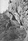
October 15, 1966 Southern end of Window Mountain[5] Santa Rosa 157 Victoria Mine 
September 1, 1978 North of Lukeville
31°55′46″N 112°50′11″W / 31.929444°N 112.836389°WLukeville 158 Villa Catalina December 22, 2009 3000-3034 E. 6th St. and 521-525 N. Country Club Rd.
32°13′39″N 110°55′41″W / 32.227467°N 110.927925°WTucson 159 Solomon Warner House and Mill June 3, 1976 350 S. Grand Ave.
32°12′52″N 110°59′16″W / 32.214444°N 110.987778°WTucson 160 West University Historic District December 10, 1980 Roughly bounded by Speedway Boulevard, 6th St., and Park and Stone Aves.
32°13′50″N 110°57′41″W / 32.230556°N 110.961389°WTucson 161 Winterhaven Historic District December 28, 2005 Bounded by Prince, Country Club, Ft. Lowell, and Tucson Boulevard
32°16′10″N 110°55′49″W / 32.269444°N 110.930278°WTucson 162 Harold Bell Wright Estate January 18, 1985 850 N. Barbara Worth
32°14′07″N 110°51′11″W / 32.235278°N 110.853056°WTucson 163 Harold Bell Wright Estates March 14, 2011 Roughly bounded by N. Wilmot Rd. on the west, E. Speedway Blvd. on north, El Dorado Hills subdivision on the east
32°13′55″N 110°51′11″W / 32.231944°N 110.853056°WTucson See also
- List of National Historic Landmarks in Arizona
- National Register of Historic Places listings in Arizona
References
- ^ The latitude and longitude information provided in this table was derived originally from the National Register Information System, which has been found to be fairly accurate for about 99% of listings. For about 1% of NRIS original coordinates, experience has shown that one or both coordinates are typos or otherwise extremely far off; some corrections may have been made. A more subtle problem causes many locations to be off by up to 150 yards, depending on location in the country: most NRIS coordinates were derived from tracing out latitude and longitudes off of USGS topographical quadrant maps created under the North American Datum of 1927, which differs from the current, highly accurate WGS84 GPS system used by Google maps. Chicago is about right, but NRIS longitudes in Washington are higher by about 4.5 seconds, and are lower by about 2.0 seconds in Maine. Latitudes differ by about 1.0 second in Florida. Some locations in this table may have been corrected to current GPS standards.
- ^ "National Register of Historic Places: Weekly List Actions". National Park Service, United States Department of the Interior. Retrieved on November 10, 2011.
- ^ Numbers represent an ordering by significant words. Various colorings, defined here, differentiate National Historic Landmark sites and National Register of Historic Places Districts from other NRHP buildings, structures, sites or objects.
- ^ NRHP name change nomination form, NRHP recent listings for 15 August 2008.
- ^ Location derived from Kurtén, Björn, and Elaine Anderson. Pleistocene mammals of North America, "Ventana Cave". New York: Columbia UP, 1980. Accessed 2010-01-06. The NRIS lists the site as "Address Restricted".
U.S. National Register of Historic Places Topics Lists by states Alabama • Alaska • Arizona • Arkansas • California • Colorado • Connecticut • Delaware • Florida • Georgia • Hawaii • Idaho • Illinois • Indiana • Iowa • Kansas • Kentucky • Louisiana • Maine • Maryland • Massachusetts • Michigan • Minnesota • Mississippi • Missouri • Montana • Nebraska • Nevada • New Hampshire • New Jersey • New Mexico • New York • North Carolina • North Dakota • Ohio • Oklahoma • Oregon • Pennsylvania • Rhode Island • South Carolina • South Dakota • Tennessee • Texas • Utah • Vermont • Virginia • Washington • West Virginia • Wisconsin • WyomingLists by territories Lists by associated states Other Properties on the National Register of Historic Places in Arizona 
Municipalities and communities of Pima County, Arizona Cities 
Towns CDPs Ajo | Avra Valley | Casas Adobes | Catalina | Catalina Foothills | Corona de Tucson | Drexel-Alvernon | Drexel Heights | East Sahuarita | Flowing Wells | Green Valley | Littletown | Picture Rocks | Pisinemo | Rincon Valley | Santa Rosa | Sells | Summit | Tanque Verde | Three Points | Tortolita | Tucson Estates | Vail | Valencia West
Unincorporated
communitiesIndian reservations Ghost towns Allen | Cerro Colorado | Helvetia | Kentucky Camp | Redington | Total Wreck
Categories:- National Register of Historic Places in Arizona by county
- Pima County, Arizona
- History of Pima County, Arizona
-


Wikimedia Foundation. 2010.