DeBordieu, South Carolina
- DeBordieu, South Carolina
-
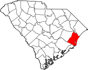
DeBordieu, DeBordieu Beach or DeBordieu Colony is a private community in Georgetown County, South Carolina. It covers 2,700 acres (11 km2) of land and wildlife preserve. DeBordieu is located south of Pawleys Island and north of Georgetown just off of U.S. Route 17. It is a gated community with a private golf and country club.
The development was named for the DeBordieu family, Huguenot planters who were in the area since the 1700's. The community is now controversial because the instability of the beach at this location (one reason it was developed so late in the history of the SC coast) has led homeowners to attempt to build groins which would adversely affect the nearby world famous Baruch research property and other private properties. The owners could renourish the beach as an alternative, without endangering other areas, but nevertheless pursue permits to allow an option that will cause significant damage to others (including the public interest in research at Baruch) but cost them less. The controversy is reported in the 9 June 2011 issue of The State, Columbia, SC.
External links
Coordinates: 33°22′09″N 79°09′06″W / 33.36917°N 79.15167°W / 33.36917; -79.15167
Wikimedia Foundation.
2010.
Look at other dictionaries:
Georgetown County, South Carolina — Infobox U.S. County county = Georgetown County state = South Carolina map size = 200 founded = 1769 seat = Georgetown | area total sq mi =1035 area land sq mi =815 area water sq mi =220 area percentage = 21.27% census yr = 2000 pop = 55797… … Wikipedia
National Register of Historic Places listings in Georgetown County, South Carolina — Location of Georgetown County in South Carolina This is a list of the National Register of Historic Places listings in Georgetown County, South Carolina. This is intended to be a complete list of the properties and districts on the National… … Wikipedia
Murrells Inlet, South Carolina — Fishing Village Nickname(s): Seafood Capital of South Ca … Wikipedia
North Santee, South Carolina — Hopsewee Historical Marker North Santee is an unincorporated community in Georgetown County, South Carolina. It is located south of Georgetown on U.S. Route 17 on the Santee Rivers. Thomas Lynch, Jr. was born here in North Santee vicinity at the… … Wikipedia
Grand Strand — The Grand Strand or Long Bay refers to a large stretch of beaches extending from Calabash, North Carolina to Georgetown, South Carolina. It consists of 60+ miles along an essentially uninterrupted arc of beach land, beginning around Little River … Wikipedia
U.S. Route 17 — Infobox U.S. Route article route=17 length mi=1189 length round=0 length ref= [http://www.us highways.com/us1830.htm US Highways from US 1 to US 830] Robert V. Droz] yrcom=1926 direction a=South from=jct|state=FL|US|41|FL|35|FL|45 in Punta Gorda … Wikipedia
Condado de Georgetown — Condado de los Estados Unidos … Wikipedia Español
Myrtle Beach metropolitan area — Horry County is in Red while Georgetown County is in yellow The Myrtle Beach metropolitan area (also Myrtle Beach Conway North Myrtle Beach MSA) is a census designated metropolitan area in Horry County and Georgetown County, South Carolina. It… … Wikipedia
WMBF-TV — Infobox Broadcast call letters = WMBF TV city = station station slogan = Live. Local. Late Breaking. station branding = WMBF News analog = Time Warner cable 10 digital = 32 (UHF) Time Warner cable 805 cable = 10 subchannels = affiliations = NBC… … Wikipedia
Comté de Georgetown — 33° 25′ N 79° 18′ W / 33.41, 79.30 … Wikipédia en Français