- Black Hills
-
This article is about the region in South Dakota. For other places, see Black Hills (disambiguation).

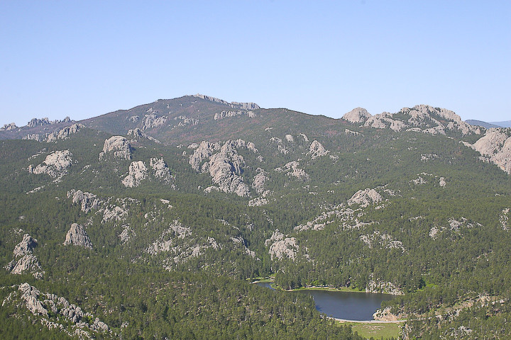
The Black Hills (Pahá Sápa in Lakota, Moʼȯhta-voʼhonáaeva in Cheyenne) are a small, isolated mountain range rising from the Great Plains of North America in western South Dakota and extending into Wyoming, USA.[1] Set off from the main body of the Rocky Mountains, the region is something of a geological anomaly—accurately described as an "island of trees in a sea of grass". Harney Peak, which rises to 7,244 feet (2,208 m), is the range's highest summit.[2] The Black Hills encompass the Black Hills National Forest and are home to the tallest peaks of continental North America east of the Rockies.
The name "Black Hills" is a translation of the Lakota Pahá Sápa. The hills were so-called because of their dark appearance from a distance, as they were covered in trees.[3]
Native Americans have a long history in the Black Hills. After conquering the Cheyenne in 1776, the Lakota took over the territory of the Black Hills, which became central to their culture. In 1868, the U.S. government signed the Fort Laramie Treaty of 1868, exempting the Black Hills from all white settlement forever. However, when European Americans discovered gold there in 1874, as a result of George Armstrong Custer's Black Hills Expedition, erstwhile miners swept into the area in a gold rush. The US government re-assigned the Lakota, against their wishes, to other reservations in western South Dakota. Unlike most of South Dakota, the Black Hills were settled by European Americans primarily from population centers to the west and south of the region, as miners flocked there from earlier gold boom locations in Colorado and Montana.
As the economy of the Black Hills has shifted from natural resources (mining and timber), the hospitality and tourism industry has grown to take its place. Locals tend to divide the Black Hills into two areas: "The Southern Hills" and "The Northern Hills". The Southern Hills is home to Mount Rushmore National Memorial, Wind Cave National Park, Jewel Cave National Monument, Harney Peak (the highest point east of the Rockies), Custer State Park (the largest state park in South Dakota, and one of the largest in the US), the Crazy Horse Memorial (the largest sculpture in the world), and The Mammoth Site in Hot Springs, the world’’s largest mammoth research facility. Attractions in the Northern Hills include historic Deadwood and the Sturgis Motorcycle Rally, held each August. The first Rally was held on August 14, 1938 and the 65th Rally in 2005 saw more than 550,000 bikers visit the Black Hills. It is a key part of the regional economy. Motorcycle riders are also attracted to the Black Hills simply for the many miles of awe-inspiring scenery.[4]. While not in South Dakota, the Devils Tower National Monument located in the Wyoming Black Hills is an important nearby attraction. Devils Tower is the nation’s first national monument [5]
Contents
History
Native Americans have inhabited the area since at least 7000 BC. The Arikara arrived by 1500 AD, followed by the Cheyenne, Crow, Kiowa and Pawnee. The Lakota (also known as Sioux) arrived from Minnesota in the eighteenth century and drove out the other tribes, who moved west.[6] They claimed the land, which they called HeSapa (Black Mountains). The mountains commonly became known as the Black Hills.
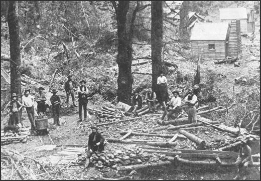
 Gold miners in the Black Hills.
The first European explorers to see the Black Hills were probably the French explorers François and Louis de La Vérendrye in 1743, but it was not until 1823 that Jedediah Smith traveled through them.[copyright violation?][7] After the public discovery of gold in the 1870s, European Americans increasingly encroached on Lakota territory. The conflict over control of the region sparked the Black Hills War, the last major Indian War on the Great Plains. The 1868 Treaty of Fort Laramie had previously confirmed the Lakota's ownership of the Teton Sioux mountain range. Both the Sioux and Cheyenne claimed rights to the land, saying that in their cultures, it was considered the axis mundi, or sacred center of the world.
Although rumors of gold in the Black Hills had circulated for decades (see Thoen Stone and Pierre-Jean De Smet), it was not until 1874 that Brevet Major General George Armstrong Custer of the 7th US Cavalry led an expedition there and discovered gold in French Creek. An official announcement of gold was made by the newspaper reporters accompanying the expedition. The following year, the Newton-Jenney Party conducted the first detailed survey of the Black Hills. The surveyor for the party, Dr. Valentine McGillycuddy, was the first European American to ascend to the top of Harney Peak. This highest point in the Black Hills is 7242 feet above sea level.
During the 1875–1878 gold rush, thousands of miners went to the Black Hills; in 1880, the area was the most densely populated part of Dakota Territory. There were three large towns in the Northern Hills: Deadwood, Central City, and Lead. Around these were groups of smaller gold camps, towns, and villages. Hill City and Custer City sprang up in the Southern Hills. Railroads were quickly constructed to the previously remote area. From 1880 on, the gold mines yielded about $4,000,000 annually, and the silver mines about $3,000,000 annually.
 Inyan Kara is a sacred mountain to Lakota.
Following the defeat of the Lakota and their Cheyenne and Arapaho allies in 1876, the United States took control of the region, in violation of the Treaty of Fort Laramie. The Lakota never accepted the validity of the US appropriation. They continue to try to reclaim the property.
On July 23, 1980, in United States v. Sioux Nation of Indians, the Supreme Court of the United States ruled that the Black Hills were illegally taken and that remuneration of the initial offering price plus interest — nearly $106 million — be paid. The Lakota refused the settlement as they wanted the Black Hills returned to them. The money remains in an interest-bearing account, which now amounts to over $757 million, but the Lakota still refuse to take the money. They believe that accepting the settlement would validate the US theft of their most sacred land.
Geology
 The Black Hills are marked by vistas of adjacent prairie and mountains, c. 1990s
The geology of the Black Hills is complex. A Tertiary mountain-building episode is responsible for the uplift and current topography of the Black Hills region. This uplift was marked by volcanic activity in the northern Black Hills. The southern Black Hills are characterized by Precambrian granite, pegmatite, and metamorphic rocks that comprise the core of the entire Black Hills uplift. This core is rimmed by Paleozoic, Mesozoic, and Cenozoic sedimentary rocks. The stratigraphy of the Black Hills is laid out like a target, as it is an oval dome, with rings of different rock types dipping away from the center.
Precambrian
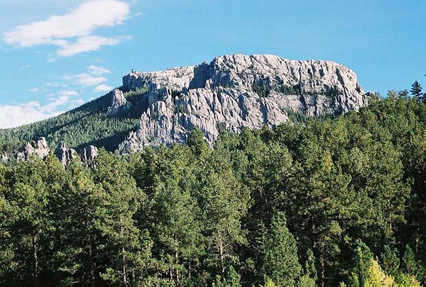
 The granite core of the Black Hills rises 7,244 feet (2,208 m) at Harney Peak
The 'bulls eye' of this target is called the granite core. The granite of the Black Hills was emplaced by magma generated during the Trans-Hudson orogeny and contains abundant pegmatite. The core of the Black Hills has been dated to 1.8 billion years. There are other localized deposits that have been dated to around 2.2 to 2.8 billion years. One of these is located in the northern hills. It is called Elk Creek Granite although it has been metamorphosed into gneiss. The other is called the Bear Mountain complex, and it is located in the west central part of the hills.
 Angular unconformity near Rapid City
Making a concentric ring around the core is the metamorphic zone. The rocks in this ring are all very old, as much as 2.0 billion years and older. This zone is very complex, filled with many diverse rock types. The rocks were originally sedimentary, until there was a collision between the North American continent and a terrane. This collision, called the Trans-Hudson Orogeny, caused the original rocks to fold and twist into a vast mountain range. Over the millions of years, these tilted rocks, which in many areas are tilted to 90 degrees or more, eroded. Today we see the evidence of this erosion in the Black Hills, where the metamorphic rocks end in an angular unconformity below the younger sedimentary layers.
Paleozoic
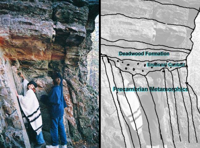
The final layers of the Black Hills consist of sedimentary rocks. The oldest lie on top of the metamorphic layers at a much shallower angle. This rock called the Deadwood Formation is mostly sandstone and was the original source of gold found in the Deadwood area. Above the Deadwood Formation lies the Englewood Formation and Pahasapa limestone, which is the source of the more than 200 caves found in the Black Hills, including Jewel Cave and Wind Cave. The Minnelusa Formation is next and is composed of highly variable sandstones and limestones followed by the Opeche shale and the Minnekahta limestone.
Mesozoic
The next rock layer, the Spearfish Formation, forms a valley around the hills called the Red Valley and is often referred to as the Race Track.[8][9] It is mostly red shale with beds of gypsum, and circles much of the Black Hills. These shale and gypsum beds as well as the nearby limestone beds of the Minnikata are used in the manufacture of cement at a cement plant in Rapid City. Next is the shale and sandstone Sundance Formation, which is topped by the Morrison Formation and the Unkpapa sandstone.
The outermost feature of the dome stands out as a hogback ridge. The ridge is made out of the Lakota Formation and the Fallriver sandstone, which are collectively called the Inyan Kara Group. Above this, the layers of rocks are less distinct and are all mainly grey shale with three exceptions: the Newcastle sandstone; the Greenhorn limestone, which contains many shark teeth fossils; and the Niobrara Formation, which is composed mainly of chalk. These outer ridges are called cuestas.
Cenozoic
 Fallingrock cliff on Dark Canyon. Paleozoic in age but it is capped with a Cenozoic gravel terrace.
The preceding layers were deposited in a horizontal manner. All of them can be seen in core samples and well logs from the flatest parts of the Great Plains. It took a period of uplift to bring them to their present topographical levels in the Black Hills. This uplift called the Laramide orogeny began around the beginning of the Cenozoic and left a line of igneous rocks through the northern hills superimposed on the rocks already discussed. This line extends from Bear Butte in the east to Devils Tower in the west. Evidence of Cenozoic volcanic eruptions, if this happened, has long since been eroded away.
The Black Hills also have a 'skirt' of gravel covering them in areas, which are called erosional terraces. Formed as the waterways cut down into the uplifting hills, they represent the former locations of today's rivers. These beds are generally around 10,000 years old or younger, judging by the artifacts and fossils found. A few places, mainly in the high elevations, are older, as old as 20 million years, according to camel and rodent fossils found. Some gravels have been found but for the most part, these older beds have been eroded away.
Biosystems
As with the geology, the biology of the Black Hills is complex. Most of the Hills are a fire-climax Ponderosa Pine forest, with Black Hills Spruce (Picea glauca var. densata) occurring in cool moist valleys of the Northern Hills. Oddly, this endemic variety of spruce does not occur in the moist Bear Lodge Mountains, which make up most of the Wyoming portion of the Black Hills. Large open parks (mountain meadows) with lush grassland rather than forest are scattered through the Hills (especially the western portion), and the southern edge of the Hills, due to the rainshadow of the higher elevations, are covered by a dry pine savannah, with stands of Mountain Mahogany and Rocky Mountain Juniper. Wildlife is both diverse and plentiful. Black Hills creeks are known for their trout, while the forests and grasslands offer good habitat for American Bison, White-tailed and Mule Deer, Pronghorn, Bighorn Sheep, mountain lions, and a variety of smaller animals, like prairie dogs, Yellow-bellied Marmots, and Fox Squirrels. Biologically, the Black Hills is a meeting and mixing place, with species common to regions to the east, west, north, and south. The Hills do, however, support some endemic taxa, the most famous of which is probably White-winged Junco (Junco hyemalis aikeni).
Tourism and economy
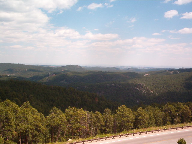
 The Black Hills opposite Mount Rushmore
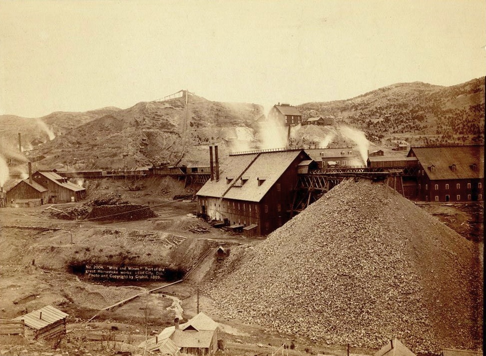
 The Homestake Mine in 1889
The region is home to Mount Rushmore National Memorial, Wind Cave National Park, Jewel Cave National Monument, Harney Peak (the highest point east of the Rockies), Custer State Park (the largest state park in South Dakota, and one of the largest in the US), Bear Butte State Park, Devils Tower National Monument, and the Crazy Horse Memorial (the largest sculpture in the world). The Black Hills also hosts the Sturgis Motorcycle Rally each August. The Rally was started in 1940 and the 65th Rally in 2005 saw more than 550,000 bikers visit the Black Hills. It is a key part of the regional economy. Motorcycle riders are also attracted to the Black Hills simply for the many miles of awe-inspiring scenery.[10]
The George S. Mickelson Trail is a recently opened multi-use path through the Black Hills that follows the abandoned track of the historic railroad route from Edgemont to Deadwood. The train used to be the only way to bring supplies to the miners in the Hills. The trail is about 110 miles in length, and can be used by hikers, cross-country skiers, and bikers. The cost is two dollars per day, or ten dollars annually.
Today, the major city in the Black Hills is Rapid City, with an incorporated population of almost 70,000 and a metropolitan population of 125,000. It serves a market area covering much of five states: North and South Dakota, Nebraska, Wyoming, and Montana. In addition to tourism and mining (including coal, specialty minerals, and the now declining gold mining), the Black Hills economy includes ranching (sheep and cattle, primarily, with bison and ratites becoming more common), timber (lumber), Ellsworth Air Force Base, and some manufacturing, including jewelry, cement, electronics, cabinetry, guns and ammunition.
In many ways, the Black Hills functions as a very spread-out urban area with a population (not counting tourists) of 250,000. Other important Black Hills cities and towns include:
- Belle Fourche, a ranching town
- Spearfish, home of Black Hills State University
- Deadwood, a historic and well-preserved gambling mecca
- Lead, home of the now-closed Homestake Mine (gold)
- Keystone, outside Mount Rushmore
- Hill City, a timber and tourism town in the center of the Hills
- Custer, a mining and tourism town and headquarters for Black Hills National Forest
- Hot Springs, an old resort town in the southern Hills
- Sturgis, originally a military town (Fort Meade, now a VA center, is located just to the east). Now famous for one of the largest motorcycle rallies in the world.
- Newcastle, center of the Black Hills petroleum production and refining.
See also
- Black Hills Gold Rush
- Black Hills Central Railroad
- Cypress Hills (Canada)
- Devils Tower National Monument
- JoAnn Tall
- The Needles
- Pine Ridge Reservation
- Black Hills Land Claim
References
- ^ "Black Hills". Geographic Names Information System, U.S. Geological Survey. http://geonames.usgs.gov/pls/gnispublic/f?p=gnispq:3:::NO::P3_FID:1267020.
- ^ "Harney". NGS data sheet. U.S. National Geodetic Survey. http://www.ngs.noaa.gov/cgi-bin/ds_mark.prl?PidBox=OT0810. Retrieved 2011-05-10.
- ^ Black Hills National Forest - Frequently Asked Questions
- ^ Joe Berk (January/February 2009). "Riding the Black Hills". Motorcycle Classics. http://www.motorcycleclassics.com/touring-destinations/ride-the-black-hills.aspx. Retrieved 2009-08-05.
- ^ {{cite web|url=http://www.blackhillsbadlands.com/home/citiestowns/wyomingregion
- ^ "The Buffalo War". PBS: Public Broadcasting Service.
- ^ "History of the Black Hills". U.S. National Park Service.
- ^ "Red Valley". Geographic Names Information System, U.S. Geological Survey. http://geonames.usgs.gov/pls/gnispublic/f?p=gnispq:3:::NO::P3_FID:1267034.
- ^ "Black Hills National Forest - Environment". http://www.gorp.com. http://www.gorp.com/parks-guide/travel-ta-black-hills-national-forest-rapid-city-sidwcmdev_066660.html. Retrieved 2010-07-27.
- ^ Joe Berk (January/February 2009). "Riding the Black Hills". Motorcycle Classics. http://www.motorcycleclassics.com/touring-destinations/ride-the-black-hills.aspx. Retrieved 2009-08-05.
External links
 State of South Dakota
Topics - Delegations
- Famous South Dakotans
- Geography
- Government
- History
- Transportation
- Symbols
- Universities
- Visitor Attractions
Society - Culture
- Crime
- Demographics
- Economy
- Education
- Politics
Regions - Badlands
- Black Hills
- Coteau des Prairies
- Coteau du Missouri
- Dissected Till Plains
- East River
- Pine Ridge
- Siouxland
- West River
Larger cities
pop. over 5,000Smaller cities
pop. over 1,000- Baltic
- Beresford
- Britton
- Canton
- Chamberlain
- Clark
- Clear Lake
- Crooks
- Custer
- De Smet
- Deadwood
- Dell Rapids
- Eagle Butte
- Elk Point
- Flandreau
- Fort Pierre
- Freeman
- Garretson
- Gettysburg
- Gregory
- Groton
- Harrisburg
- Hartford
- Hot Springs
- Lead
- Lemmon
- Lennox
- Martin
- Milbank
- Miller
- Mission
- Mobridge
- North Sioux City
- Parker
- Parkston
- Platte
- Redfield
- Salem
- Sisseton
- Springfield
- Summerset
- Tea
- Tyndall
- Volga
- Wagner
- Webster
- Winner
Largest CDPs
pop. over 1,000Counties - Aurora
- Beadle
- Bennett
- Bon Homme
- Brookings
- Brown
- Brule
- Buffalo
- Butte
- Campbell
- Charles Mix
- Clark
- Clay
- Codington
- Corson
- Custer
- Davison
- Day
- Deuel
- Dewey
- Douglas
- Edmunds
- Fall River
- Faulk
- Grant
- Gregory
- Haakon
- Hamlin
- Hand
- Hanson
- Harding
- Hughes
- Hutchinson
- Hyde
- Jackson
- Jerauld
- Jones
- Kingsbury
- Lake
- Lawrence
- Lincoln
- Lyman
- Marshall
- McCook
- McPherson
- Meade
- Mellette
- Miner
- Minnehaha
- Moody
- Pennington
- Perkins
- Potter
- Roberts
- Sanborn
- Shannon
- Spink
- Stanley
- Sully
- Todd
- Tripp
- Turner
- Union
- Walworth
- Yankton
- Ziebach
 State of Wyoming
Topics - Governors
- Delegations
- Geography
- Government
- History
- People
- Visitor Attractions
- State Symbols
- Radio Stations
Society - Crime
- Demographics
- Economy
- Education
- Politics
Regions - Black Hills
- Grand Teton
- Great Basin
- Powder River Country
- Red Desert
- Yellowstone
Cities Counties Categories:- Black Hills
- Physiographic sections
- Mountain ranges of the United States
- Regions of South Dakota
- Regions of Wyoming
- Great Plains
- Tertiary volcanism
- Sacred mountains
- Religious places of the indigenous peoples of North America
- Lakota mythology
- Economy of South Dakota
- Great Sioux War of 1876–77


Wikimedia Foundation. 2010.