Missouri Route 133

Missouri Route 133

Route 133 marker

Route 133
Route information
Maintained by MoDOT
Length: 67 mi (108 km)
Major junctions
South end: I-44.svgMO-supp-AB.svg Interstate 44/Route AB west of Waynesville
North end: US 63.svg U.S. Route 63 north of Westphalia
Highway system

Missouri Highways
Supplemental

Route 131 Route 134

Route 133 is a highway in central Missouri. Its northern terminus is at U.S. Route 63 near Westphalia; its southern terminus is at Interstate 44 about fourteen miles (21 km) west of Waynesville.

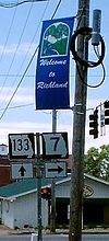
Highway 133 passes through Richland, where the highway intersects with Route 7.

1337intersection.JPG


Wikimedia Foundation. 2010.

Игры ⚽ Поможем написать реферат

Look at other dictionaries:

  • Missouri Route 52 — Route 52 Route information Maintained by MoDOT Length: 173 mi (278 km) Existed …   Wikipedia

  • Missouri Route 131 — Route 131 Route information Maintained by MoDOT Length: 38 mi (61 km) …   Wikipedia

  • Missouri Route 134 — Route 134 Route information Maintained by MoDOT Length: 9 mi (14 km) …   Wikipedia

  • Missouri Route 7 — For the former Route 7, see Route 7 (Missouri 1922). MO 7 redirects here. MO 7 may also refer to Missouri s 7th congressional district. Route 7 Route information Maintained by MoDOT …   Wikipedia

  • Missouri Route 6 — MO 6 redirects here. MO 6 may also refer to Missouri s 6th congressional district. Route 6 Route information Maintained by MoDOT Length …   Wikipedia

  • List of highways numbered 133 — The following highways are numbered 133: Canada Route 133 (Prince Edward Island) Quebec Route 133 United States Alabama State Route 133 Arkansas High …   Wikipedia

  • Comté de Maries (Missouri) — Comté de Maries Comté de Maries Localisation du Comté …   Wikipédia en Français

  • Missouri State Capitol — showing the Missouri River in the background The Missouri State Capitol is located in the U.S. state of Missouri. Housing the Missouri General Assembly, it is located in the state capital of Jefferson City at 201 West Capitol Avenue. The domed… …   Wikipedia

  • Missouri River — Coordinates: 38°48′49″N 90°07′11″W / 38.81361°N 90.11972°W / 38.81361; 90.11972 …   Wikipedia

  • Crocker, Missouri —   City   Location of Crocker …   Wikipedia

Share the article and excerpts

Direct link
Do a right-click on the link above
and select “Copy Link”