- Modernist Housing Estates
-
Berlin Modernism Housing Estates * UNESCO World Heritage Site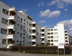
"Panzerkreuzer" Estate, designed by Hans ScharounType Cultural Criteria ii, iv Reference 1220 Region ** Europe and North America Inscription history Inscription 2008 (32nd Session) * Name as inscribed on World Heritage List
** Region as classified by UNESCOBerlin Modernism Housing Estates consists of six subsidized housing estates (Siedlungen) that testify to innovative housing policies from 1910 to 1933, especially during the Weimar Republic, when the city of Berlin was particularly progressive socially, politically and culturally. The properties are outstanding examples of the building reform movement that contributed to improving housing and living conditions for people with low incomes through novel approaches to town planning, architecture and garden design. The estates also provide exceptional examples of new urban and architectural typologies, featuring fresh design solutions, as well as technical and aesthetic innovations.
Bruno Taut, Martin Wagner and Walter Gropius were among the leading architects of these projects which exercised considerable influence on the development of housing around the world.
List of Housing Estates
Settlement Location Dates Planner Architect Image Gartenstadt Falkenberg
Tuschkastensiedlung ("Paintbox Estate")Bohnsdorf 1913–1916 Bruno Taut Bruno Taut
Heinrich Tessenow
Siedlung Schillerpark Wedding 1924–1930 Bruno Taut Bruno Taut
Max Taut
Hans Hoffmann (enlargement 1954-1959)
Großsiedlung Britz
Hufeisensiedlung ("Horseshoe Estate")Britz 1925–1930 Bruno Taut Bruno Taut
Martin Wagner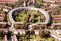
Wohnstadt Carl Legien Prenzlauer Berg 1928–1930 Bruno Taut Bruno Taut
Franz Hillinger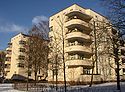
Weiße Stadt (White City) Reinickendorf 1929–1931 Otto Rudolf Salvisberg
Martin Wagner (direction)Otto Rudolf Salvisberg
Bruno Ahrends
Wilhelm Büning
Großsiedlung Siemensstadt
RingsiedlungCharlottenburg-Nord 1929–1934 Hans Scharoun
Martin Wagner (direction)Hans Scharoun
Walter Gropius
Otto Bartning
Fred Forbat
Hugo Häring
Paul Rudolf Henning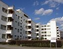 Categories:
- World Heritage Sites in Germany
- Housing in Germany
- Modernist architecture in Germany
- Buildings and structures in Berlin
- Visitor attractions in Berlin


Wikimedia Foundation. 2010.