- Cythera (island)
-
Cythera
Κύθηρα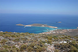
Kythira's main port DiakoftiLocation 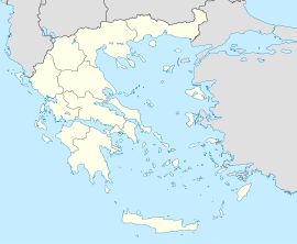
 Cythera
Coordinates 36°24′N 23°0′E / 36.4°N 23°ECoordinates: 36°24′N 23°0′E / 36.4°N 23°E Location within the region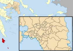
Government Country: Greece Region: Attica Regional unit: Islands Population statistics (as of 2001) Municipality - Population: 3,398 - Area: 299.4 km2 (116 sq mi) - Density: 11 /km2 (29 /sq mi) Municipal unit - Population: 3,354 - Area: 279.6 km2 (108 sq mi) - Density: 12 /km2 (31 /sq mi) Community - Population: 579 Other Time zone: EET/EEST (UTC+2/3) Elevation (center): 506 m (1,660 ft) Postal: 801 00 Telephone: 2736 Auto: Z Website www.kythira.gr Cythera (Greek: Κύθηρα, also transliterated Kythera, Kythira, Kithira. The Italian Cerigo can be used in speaking of late medival and early modern Cythera.) is an island in Greece, once part of the Ionian Islands. It lies opposite the south-eastern tip of the Peloponnese peninsula. It is administratively part of the Islands peripheral unit, which is part of the Attica Periphery (although at large distance from Attica itself), Greece.
For many centuries, while naval travel was the only means for transportation, the island possessed a strategic location. Since ancient times, until the mid 19th century, Kythira had been a crossroads of merchants, sailors, and conquerors. As such, it has had a long and varied history and has been influenced by many civilisations and cultures. This is reflected in its architecture (a blend of traditional, Aegean and Venetian elements), as well as the traditions and customs, influenced by centuries of coexistence of the Greek, Venetian, Ottoman and British civilisations as well as its numerous visitors.
Contents
Municipality
Cythera and the adjacent island of Antikythera were separate municipalities until they were merged at the 2011 local government reform; the two islands are now municipal units:[1]
Geography
Cythera has a land area of 279.593 km² (107.951 sq mi); it is located at the southwestern exit from the Aegean Sea, behind Cape Malea.[2] The rugged terrain is a result of prevailing winds from the surrounding seas which have shaped its shores into steep rocky cliffs with deep bays. The island has many beaches, of various composition and size; only half of them can be reached by road through the mountainous terrain of the island.
Cythera is close to the Hellenic arc plate boundary zone, and thus, a highly seismogenic part of the region. Many earthquakes in recorded history have had their epicentres near or on the island. Probably the largest in recent times is the 1903 earthquake near at the village of Mitata, that caused significant damage as well as limited loss of life. It has had two major earthquakes in the 21st century: that of November 5, 2004, an earthquake measuring between 5.6 and 5.8 on the Richter scale and the earthquake of January 8, 2006, measuring 6.9 on the Richter scale. The epicenter of the latter was in the sea about 20 km to the east of Kythira, at a depth of approximately 70 km. Many buildings were damaged, particularly old ones, mostly in the village of Mitata, but nobody was killed. It was felt as far as Italy, Egypt, Malta and Jordan.
The Kythirian Straits, formed by the southeastern peninsula of the Peloponnese and the islands of Elafonissos and Cythera represent one of the most dangerous navigational hazards in the Mediterranean. Most sea-traffic from Athens, Istanbul, and the Black Sea to the central and western Mediterranean passes through the straits and are often subject to strong winds and shipwreck on Cape Malea.
History
Pre-classical and ancient
There are archaeological remains from the Helladic period, contemporary with the Minoans. There is archaeological evidence of Cytheran trade as far as Egypt and Mesopotamia.
Cythera had a Phoenician colony is the early archaic age; the sea-snail which produces Tyrian purple is native to the island. Xenophon refers to a Phoenician Bay in Cythera (Hellenica 4.8.7, probably Avlemonas Bay on the eastern side of the island). The archaic Greek city of Cythera was at Scandea on Avlemonas; its ruins have been excavated. Its acropolis, now Palicastro (Palaeocastron, "Old Fort"), has the temple of Aphrodite Ourania, who may well represent a Phoenician cult of Astarte.
In classical times, Cythera was part of the territory of several larger city-states. Sparta took the island from Argos early in the sixth century, and ruled it under a kytherodíkes (kυθηροδίκης, "judge on Cythera", in Thucydides' time [4,53,3]; Athens occupied it three times when at war with Sparta (in 456 during her first war with Sparta and the Peloponnesians; from 426 to 410, through most of the great Peloponnesian War; from 393 to 387 or 186, during the Corinthian War against Spartan dominance; from , and used it both to support her trade and to raid Laconia.
Cythera was independent, and issued her own coins, in 195, after the Achaean defeat of Sparta; in Augustus' time, it was again subject to Sparta, being the property of Gaius Julius Eurycles, who was both a Spartan magnate and a Roman citizen.
By this time, the Greek cities were in practice subject to the Roman Empire' Cythera contined to exist under the Roman Empire and its Byantine successor state for centuries; Christianity is attested from the fourth century AD, the time of Constantine; according to her legend, Saint Elessa came from Laconia to convert the island. [3]
Medieval and modern
Cythera is not mentioned in the literary sources for centuries after its conversion; in the period of Byzantine weakness at the end of the seventh century, it would have been exposed both to the Slavic trives who occupied the mainland and to Arab raiders from the sea. Archaeological evidence suggests the island was abandoned about 700 AD.
When Saint Theodore of Cythera led a resettlement after the Bysantine reconquest of Crete in 962, he found the island occupied only by wandering bands of hunters. He established a great monastery at Paliochora; a town grew up around it, largely populated from Laconia.
When the Bysantine Empire was divided among the conquerors of the Fourth Crusade, the Republic of Venice took her share, three eighths of the whole, as the Greek islands, Cythera among them. She established a coast patrol on Cythera and Antikythera to protect her trade route to Constantinople; Cythera was one of the islands Venice continued to hold destpire the Greek reconquest of Constantinople and the Turkish presence all over the Near East.[4]
Cytherans still talk about the destruction and looting of Paliochora by Barbarossa; it has become an intrinsic part of the Kytherian folklore, yet one can easily accept the stories of locals by noticing the number of monasteries embedded in the rocky hillsides to avoid destruction by the pirates.
When Napoleon put an end to the Venetian Republic in 1797, Cythera was among the islands inconrporated in that most distant départment of France, called Mer-Égée. Cythera shared a common destiny with the other Ionian islands, during turbulent Napoleonic era, and is still accounted one of them; it was counted as one of the Cyclades in antiquity.
In 1799, the Ionian islands became the Septinsular Republic, nominally under Turkish suzerainity, but in practice dominsted by Russia; in 1807, France took them back; in 1809, the British seized the islande set up one of their first protectorates, the United States of the Ionian Islands, and held them for nearly half a century; under the British, they were governed by a High Commissioner who could act with both legislative and executive powers. After a long history of turbulence, never settled even by such eminent Commissioners as William Ewart Gladstone, the British discussion whether they were a waste of money or a viral Imperial possession ended with the cession of the Ionian Islands, including Cythera, to the new King George I of Greece, who has brother-in-law to the Prince of Wales.
The chief town of the island, Cythera (or Chora, "village") has the Historical Archives of Cythera, the second largest in the Ionian islands, after Corfu.
Mythology
In Ancient Greek mythology, Kythira was considered to be the island of celestial Aphrodite, the Goddess of love, (cf. Cyprus, the island of Astarte, the Goddess of Love).
Demographics
Like many of the smaller Aegean islands, Kythira's population is decreasing. While the island had reached a peak population of about 14,500 in 1864, that has steadily declined mostly due to emigration, both internal (to major urban centres of Greece) and external (to Australia, the United States, Germany) in the first half of the 20th century. Today its population hovers around 3,354 people (2001 census), but the modern Greek diaspora has produced around 60,000 Kytherian descendants in Australia alone.
Villages of Kythira
The largest villages (2001 Greek census) are Potamós (pop. 396), Agía Pelagía (281), Chóra/Kýthira (267), Áno Livádi (175), Kálamos (157), and Livádi (126).
 View of Avlemonas.
- Agia Pelagia Kythira, Port
- Agios Ilias
- Alexandrades
- Ano Livadi
- Aroniadika
- Avlemonas
- Chora, (also Kythira) Kytherian Capital
- Christoforianika
- Diakofti, Port
- Fratsia
- Friligianika
- Gerakaria
- Kalamos
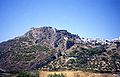
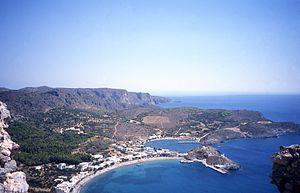 View of Kapsali from the castle in Chora.
- Kapsali
- Karavas
- Karvounades
- Kastrisianika
- Keramoto
- Kontolianika
- Livadi, which is becoming the business center of the island
- Katouni
- Logothetianika
- Louriantianika
- Mitata
- Mylopotamos
- Pitsinianika
- Platia Amos
- Potamos, largest village
- Stathianika
- Viaradika
- Vouno
Economy
Since the late 20th century, the Kythirean economy has largely focused and, in the process, has become dependent on tourism, which provides the majority of the island's income, despite the fact that Kythira is not one of the most popular tourist destinations in Greece. The popular season usually begins with the Greek holiday of Pentecost at the end of May, and lasts until the middle of September. During this time, primarily during August, the island's population will often triple due to the tourists and natives returning for vacation. Dependence on tourism has resulted in increased building activity in many of the island's villages, mostly for commercial purposes (hotels and hospitality facilities, shops etc.), but also secondary homes; prominent examples are Agia Pelagia and Livadi, both of which having witnessed significant growth in their size since the early 1990s.
Minor sources of revenue are thyme honey, famous within Greece for its rich flavor, as well as some small-scale cultivation of vegetables and fruit and animal husbandry that is, nevertheless, increasingly restricted to local consumption.
Only five of the island's villages are on the coast (Platia Amos, Agia Pelagia, Diakofti, Avlemonas, & Kapsali). During July and August, several traditional dances will be held in various villages. These dances usually attract the majority of the island's population, the biggest of which are the festival of 'Panagia' in Potamos on the 15th of August, and the wine festival in Mitata on the first Friday and Saturday of August.
Kythira (town)
 View of the capital, Chora.
The capital, Chora, is located on the southern part of the island having no ports connected to the southern Peloponnese or Vatika. Kythira's port for Vatika was previously situated at Agia Pelagia, although in recent years this port has been decommissioned and has been replaced by a new port at the coastal town of Diakofti, Kythira.
Most of the over 60 village names end with "-anika" and a few end with -athika, -iana and -ades. This is due to the villages being named after influential families that settled first in that region. For Example, 'Logothetianika' is derived from the Greek last name of 'Logothetis'.
Transportation
The island in the past has been plagued by a poor infrastructure, exacerbated by the effect of weather on transportation during the winter months. However the construction of the new port in Diakofti along with the renovation of the island's airport have significantly reduced these effects. A new road from the island's most populated town of Potamos in the north to the island's capital of Chora in the south is currently in the planning and development stage.
Port
Despite the fact that the island has been a trade route for centuries, construction of a modern port was postponed several times until the latter half of the 20th century. In 1933, efforts were made to construct a port in the village of Agia Pelagia, yet financial and governmental problems meant that decades later that one was built. That small port of Agia Pelagia (currently being renovated from a ferry dock to a tourist/recreational boat dock) was the island's main port until the mid-1990s. Around that time the new port of Diakofti, the site originally chosen by the island's British rulers in the 19th century, was constructed along with a modern wider road, aiming to support larger cargo and passenger vessels. The port of Diakofti currently serves scheduled routes to/from Gythion, Kalamata, Antikythera, Piraeus, Crete & Neapolis - Vatika. Proposals have been made to attach a Marina to the south side of the port, however no plans or timetables have been produced. Additionally, the harbour of Agia Patrikia (north of Agia Pelagia) is the primary fishing boat harbour, housing two wide boatramps and a boat repair facility.
Airport
The island's primary airport is the Kithira Island National Airport, located in the region between the village of Friligiannika and Diakofti, about 8 km from the capital. The airport was revamped and extended at the turn of the 21st century, largely by private funds provided by the local population. The island is served by Olympic Air flights.
Gallery
-

Panorama at Mitata.
-
View of the castle in Chora.
-

View on Kapsali
-

Church of Agios Georgios
-

View of the Kythirian Straits
-

West coast
-

Avlemonas at southeastern coast
-

Paleopoli Beach
-

Monastery of Panagia Mertidiotissa
-

Gold Icon of Panagia Mertidiotissa
-

Church of Agia Despoina
-

The castle of Kythira by night
-

Winery in Pitsinianika showing neoclassical architecture
-

Cave in islet Hytra
Notable people
- Philoxenus (435-380 BC), dithyrambic poet
- Marco Venier, Lord of Cerigo (– 1311) was a Lord of Cerigo.
- Georgios Souris, Greek poet
- Valerios Stais (1857–1923), archaeologist
- Yianis Vilaras (1771–1823), poet and author
- Juliette de Bairacli Levy (1912–2009), Herbalist and Author
- Michael Zullo, Professional Footballer for Australian based team Queensland Roar
Cultural references
- The Birth of Venus (Botticelli) and other similarly themed paintings show the goddess Venus (mythology) arriving either at the shore of Cythera or Cyprus, as classical mythology attributed both islands as her birthplace.
- The island's status as the birthplace of the goddess is also referenced in the title and subject of the Antoine Watteau painting Embarkation for Cythera.
- Charles Baudelaire, in the poem "A Voyage to Cythera", called the island a "banal Eldorado".
- The Baudelaire poem is quoted and the island is referenced in Anthony Powell, The Kindly Ones (novel) (1962), part of the A Dance to the Music of Time series of novels.
See also
References
- ^ Kallikratis law Greece Ministry of Interior (Greek)
- ^ C.Michael Hogan. 2011. Aegean Sea. Eds. P.Saundry & C.J.Cleveland. Encyclopedia of Earth. National Council for Science and the Environment. Washington DC
- ^ Brill's New Pauly, article on "Cythera" (for entire section), citing Paus. 1,27,5; Thuc. 4,53,1ff.; 57,4; 5,14,3; 18,7; 7,26,2; 57,6; Xen. Hell. 4,8,7; Isoc. Or. 4,119, and Cassius Dio 54,7,2).
- ^ Fernand Braudel, The Mediterranean and the Mediterranean world in the age of Philip IIm trans. Reynolds. In the 1995 ed. Vol II, p.877
External links
- Visit Kythera - Tourist & Culture Guide of Kythera Island (Greek)(English)(German)(French)(Italian)(Spanish)(Turkish)
- Tourist Information (Greek)(English)(Italian)
- Official website (Greek)
- The Kythera Island Project: an archaeological, ecological, and historic research project of the island and its peoples.
- Tourist Information
- Kythera-Family.net: A cultural archive for the island of Kythira, with over 15 000 heritage entries from people of Kytherian descent from all over the world.
Administrative division of the Attica Region Area: 3,808km² • Population: 3,761,810 (2001) • Capital: Athens Regional unit of Central AthensAthens • Dafni–Ymittos • Filadelfeia–Chalkidona • Galatsi • Ilioupoli • Kaisariani • Vyronas • Zografou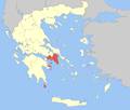 Regional unit of North AthensAgia Paraskevi • Amarousio • Chalandri • Filothei–Psychiko • Irakleio • Kifisia • Lykovrysi–Pefki • Metamorfosi • Nea Ionia • Papagou–Cholargos • Penteli • VrilissiaRegional unit of West AthensRegional unit of South AthensAgios Dimitrios • Alimos • Elliniko–Argyroupoli • Glyfada • Kallithea • Moschato–Tavros • Nea Smyrni • Palaio FaliroRegional unit of PiraeusRegional unit of East AtticaAcharnes • Dionysos • Kropia • Lavreotiki • Marathon • Markopoulo • Oropos • Paiania • Pallini • Rafina–Pikermi • Saronikos • Spata–Artemida • Vari–Voula–VouliagmeniRegional unit of West AtticaRegional unit of Islands
Regional governor: Ioannis Sgouros (el) • Website: www.patt.gov.gr Municipal unit of Cythera Aroniadika · Fratsia · Friligkianika · Karavas · Karvounades · Kontolianika · Cythera · Livadi · Logothetianika · Mitata · Mylopotamos · Myrtidia · PotamosIonian Islands Main Islands Smaller islands and islets Antikythera · Antipaxi · Arkoudi · Atokos · Drakonera · Elafonisos · Ereikoussa · Kalamos · Kastos · Kravia · Kythros · Lazaretto · Makri · Makropoula · Mathraki · Meganisi · Modia Islets · Othonoi · Oxeia · Petalas · Pistros · Pontikos · Provati · Skorpios · Sparti Lefkados · Strofades · Vidos · Vromonas ·
Categories:- Populated places in Islands (peripheral unit)
- Kythira
- Municipalities of Attica
- Mediterranean port cities and towns in Greece


Wikimedia Foundation. 2010.