- Mount Roraima
-
Mount Roraima 
Mt. Roraima in April 2004Elevation 2,810 m (9,219 ft) [1] Prominence 2,338 m (7,671 ft) [1] Listing Country high point
UltraLocation Location of Mount Roraima in western Guyana (on border with Venezuela and Brazil)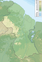
 Mount Roraima
Location Venezuela/Brazil/Guyana Range Guiana Highlands Coordinates 5°08′36″N 60°45′45″W / 5.14333°N 60.7625°WCoordinates: 5°08′36″N 60°45′45″W / 5.14333°N 60.7625°W Climbing First ascent 1884, led by Everard F. im Thurn and accompanied by Harry Inniss Perkins and several Guyanese natives[2][3]:497 Easiest route Hike Mount Roraima (also known as Roraima Tepui or Cerro Roraima in Spanish, and Monte Roraima in Portuguese) is the highest of the Pakaraima chain of tepui plateau in South America.[4]:156 First described by the English explorer Sir Walter Raleigh in 1596, its 31 km2 summit area[4]:156 is defended by 400-metre-tall cliffs on all sides. The mountain includes the triple border point of Venezuela, Brazil and Guyana.[4]:156
Mount Roraima lies on the Guiana Shield in the southeastern corner of Venezuela's 30000 km2 Canaima National Park forming the highest peak of Guyana's Highland Range. The tabletop mountains of the park are considered some of the oldest geological formations on Earth, dating back to some two billion years ago in the Precambrian.
The highest point in Guyana and the highest point of the Brazilian state of Roraima lie on the plateau, but Venezuela and Brazil have higher mountains elsewhere. The triple border point is at 5°12′08″N 60°44′07″W / 5.20222°N 60.73528°W, but the mountain's highest point is Maverick Rock, 2810 m, at the south end of the plateau and wholly within Venezuela.
Contents
Flora and fauna
Many of the species found on Roraima are unique to the plateau.[5] Plants such as pitcher plants, Campanula (a bellflower), and the rare Rapatea heather are commonly found on the escarpment and summit.[4]:156–157 It rains almost every day of the year. Almost the entire surface of the summit is bare sandstone, with only a few bushes (Bonnetia roraimœ) and algae present.[3]:517[6]:464[7]:63 "[L]ow scanty and bristling vegetation" is also found in the small, sandy marshes that intersperse the rocky summit.[3]:517 Most of the nutrients that are present in the soil are washed away by torrents that cascade over the edge, forming some of the highest waterfalls in the world.
Culture
Since long before the arrival of European explorers, the mountain has held a special significance for the indigenous people of the region, and it is central to many of their myths and legends. The Pemon Indians of the Gran Sabana see Roraima as the stump of a mighty tree that once held all the fruits and tuberous vegetables in the world. Felled by one of their ancestors, the tree crashed to the ground, unleashing a terrible flood. Roroi in the Pemon language means blue-green and ma means great.[citation needed]
In 2006, Mount Roraima was the destination for the award-winning Gryphon Productions two hour television documentary The Real Lost World. The program was shown on Animal Planet, Discovery HD Theater and OLN (Canada). Directed by Peter von Puttkamer, this travel/adventure documentary featured a modern team of explorers: Rick West, Dr. Hazel Barton, Seth Heald, Dean Harrison and Peter Sprouse who followed in the footsteps of British explorers Im Thurn and Harry Perkins who sought the flora and fauna of Roraima in the mid-19th century. The adventures of those explorers may have inspired Arthur Conan Doyle's seminal book about people and dinosaurs, The Lost World, published in 1912.[4]:156 In 2006, The Real Lost World team were the first scientific team to explore the caves of Roraima, only recently discovered. Inside they found intriguing "carrot" formations growing in the 2 billion year old caves. Dr. Hazel Barton returned in 2007 on a NASA funded expedition to investigate the features growing on the cave walls and ceiling: evidence of extremophile cave microbes eating the silica-based walls of the cave and leaving dusty deposits on ancient spiderwebs, forming these unique stalactite type shapes. They could provide clues to how life forms and survives on other planets.
In 2009, Mount Roraima served as inspiration for a location in the Disney/Pixar animated movie Up.[8] The Blu-ray version of the movie disc bonus footage features a short film (called Adventure Is Out There) about some of the Pixar production team going to Mount Roraima and climbing it for inspiration and ideas for the making of Up.
Ascensions
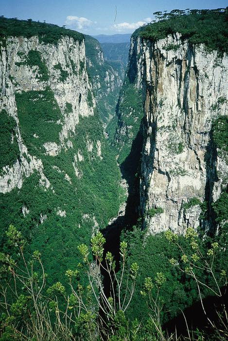
 The steep rock wall of Monte Roraima.
Although the steep sides of the plateau make it difficult to access, it was the first major tepui to be climbed: Sir Everard im Thurn walked up a forested ramp in December 1884 to scale the plateau. This is the same route hikers take today.
Today, Mount Roraima is a destination for backpackers. Almost all who go up the mountain approach it from the Venezuelan side. Most hikers hire a Pemon Indian guide in the village of Paraitepui, which is reached by dirt road from the main Gran Sabana road between kilometre 88 and Santa Elena de Uairen. Although the path to reach the plateau is well marked and popularly traveled, it is easy to get lost on top of the mountain, as there are few distinct trails and the near constant cloud cover on top and the uncanny rock formations make visual references problematic. Paraitepui can be reached easily by four wheel drive vehicle, with great difficulty by car if the unpaved road conditions are unusually fine, or by foot in about a day.[citation needed]
From Paraitepui, most hikers take one day to reach the base of the mountain, and then another day to follow "La Rampa" a natural staircase-like path, up to the top. Another two days are typically needed for the return, and many people spend one day and night on top of the mountain, making five days in total. Longer treks can reach the northern portion of the tepui, mostly in Guyana, with less explored and more intriguing sites such as Lake Gladys, although this offers more dangers than its more popular southern part and should only be attempted by well-supplied groups. The less adventurous can also reach the mountain, weather permitting, by helicopter tours available from the nearby Venezuelan city of Santa Elena de Uairén.[citation needed]
The only non-technical route to the top is the Paraitepui route; any other approach will involve climbing gear. Mount Roraima has been climbed on a few occasions from the Guyana and Brazil sides, but as the mountain is entirely bordered on both these sides by enormous sheer cliffs that include high overhanging (negative-inclination) stretches, these are extremely difficult and technical rock climbing routes. Such climbs would also require difficult authorizations for entering restricted-access national parks in the respective countries. As of 2009[update], climbing from the Brazilian side would be particularly problematic, due to the access being through Raposa-Serra do Sol Amerindian reserve, where armed conflicts between the natives, white rice farmers and the authorities have been frequent.[citation needed]
References
 Utricularia campbelliana from Mount Roraima
- ^ a b "Monte Roraima, Venezuela". Peakbagger.com. http://www.peakbagger.com/peak.aspx?pid=8684.
- ^ From The Times (May 22, 1885), "Mr. im Thurn's Achievement" (PDF), The New York Times (New York City, United States: The New York Times Company): 3, ISSN 0362-4331, OCLC 1645522, http://query.nytimes.com/mem/archive-free/pdf?res=9F02EED91739E533A25751C2A9639C94649FD7CF, retrieved November 15, 2009, "Lord Aberdare said that Mr. Perkins, who accompanied Mr. im Thurn in the ascent of the mountain, had fared little better, inasmuch as he also had been severely attacked by fever since his return, and though present that evening, was still too weak to read his notes."
- ^ a b c im Thurn, Everard (August 1885), "The Ascent of Mount Roraima", Proceedings of the Royal Geographical Society and Monthly Record of Geography, New Monthly Series (London, England, U.K.: Blackwell Publishing, on behalf of the Royal Geographical Society, with the Institute of British Geographers) 7 (8): 497–521, doi:10.2307/1800077, ISSN 0266-626X, JSTOR 1800077, OCLC 51205375, http://books.google.com/?id=WjARAQAAIAAJ&vq=497&pg=PA497-IA4#v=onepage&q=, retrieved November 14, 2009, "For all around wore rocks and pinnacles of rocks of seemingly impossibly fantastic forms, standing in apparently impossibly fantastic ways—nay, placed one on or next to the other in positions seeming to defy every law of gravity—rocks in groups, rocks standing singly, rocks in terraces, rocks as columns, rocks as walls and rooks as pyramids, rocks ridiculous at every point with countless apparent caricatures of the faces and forms of men and animals, apparent caricatures of umbrellas, tortoises, churches, cannons, and of innumerable other most incongruous and unexpected objects."
- ^ a b c d e Swan, Michael (1957), British Guiana, London, England, U.K.: Her Majesty's Stationery Office, OCLC 253238145, http://books.google.com/?id=f9MwAAAAIAAI, "Mount Roraima is the point where the boundaries of Venezuela, Brazil and British Guiana actually meet, and a stone stands on its summit, placed there by the International Commission in 1931."
- ^ Green, Reg (July 24, 2009, 15:30 (PDT)), "The Lost World of Venezuela's Mt. Roraima", Los Angeles Times (Los Angeles, CA, U.S.A.: Tribune Company), ISSN 0458-3035, OCLC 37745847, http://cms.travel.latimes.com/articles/la-trw-venezuela26-2009jul26, retrieved November 14, 2009, "The result of all that isolation: an abundance of plants and animals found nowhere else in the world, including a tiny black frog so primitive that it hasn't yet learned to hop but, when threatened, baffles its enemies by turning itself into a ball and rolling off the rocks."
- ^ Clementi (née Eyres), Marie Penelope Rose (December 1916), "A Journey to the Summit of Mount Roraima", The Geographical Journal (London, England, U.K.: Blackwell Publishing, on behalf of the Royal Geographical Society, with the Institute of British Geographers) 48 (6): 456–473, doi:10.2307/1779816, ISSN 0016-7398, JSTOR 1779816, OCLC 1570660, "The summit is covered with enormous black boulders, weathered into the weirdest and most fantastic shapes. We were in the middle of an amphitheatre, encircled by what one might almost call waves of stone. It would be unsafe to explore this rugged plateau without white paint to mark one's way, for one would be very soon lost in the labyrinth of extraordinary rocks. There is no vegetation on Roraima save a few dampsodden bushes (Bonnetia Roraimœ), and fire sufficient for cooking can be raised only by an Indian squatting beside it and blowing all the time."
- ^ Tate, G. H. H. (January 1930), "Notes on the Mount Roraima Region", Geographical Review (New York, New York, U.S.A.: American Geographical Society) 20 (1): 53–68, doi:10.2307/209126, ISSN 0016-7428, JSTOR 209126, OCLC 1570664, "In general the interior plateau looks flat and monotonous. Appearance is deceptive, for there are actually very few places where walking is not difficult, and these follow the joint system of the sandstone. For the most part, tumbled masses of rock, rifts, and gorges and whole acres of ten-foot mushrooms and loaves of bread formed in stone offer a maze in which one may wander long before finding better ground; while gullies many yards in depth and breadth, meandering undecidedly, force detours of sometimes half a mile."
- ^ Power, Ed (October 2, 2009), "Up and away", Irish Independent (Dublin, Ireland: Independent News and Media), ISSN 0021-1222, OCLC 60623153, http://www.independent.ie/entertainment/day-and-night/features/up-and-away-1902495.html, retrieved November 14, 2009, "In order to make sure that they got their South American backdrops right, Docter and 11 other Pixar artists visited the famously inaccessible Monte Roraima region of Venezuela."
External links
- Mount Roraima on SummitPost.org
- National Geographic's 2004 Biological Exploration of the Cliffs
- History of exploration on Mount Roraima
- A walk around the top of Mount Roraima
Highest Points of Brazilian states Acre • Alagoas • Amapá • Amazonas • Bahia • Ceará • Distrito Federal • Espírito Santo • Goiás • Maranhão • Mato Grosso • Mato Grosso do Sul • Minas Gerais • Pará • Paraíba • Paraná • Pernambuco • Piauí • Rio de Janeiro • Rio Grande do Norte • Rio Grande do Sul • Rondônia • Roraima • Santa Catarina • São Paulo • Sergipe • Tocantins
Categories:- Highest points of Brazilian states
- Tepuis
- Mountains of Brazil
- Mountains of Guyana
- Mountains of Venezuela
- Plateaus of South America
- Brazil–Venezuela border
- Brazil–Guyana border
- Guyana–Venezuela border
- International mountains of South America
- Border tripoints


Wikimedia Foundation. 2010.