- Chadderton Power Station
-
Chadderton A & B power stations 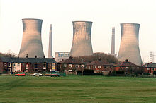
Chadderton B Power Station shortly before demolition in 1986Location of Chadderton A & B power stations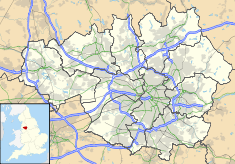

Country England Location Chadderton Coordinates 53°31′54″N 2°09′57″W / 53.531640°N 2.165911°WCoordinates: 53°31′54″N 2°09′57″W / 53.531640°N 2.165911°W Status Demolished Construction began A station: 1925
B station: 1950Commission date A station: 1927
B station: 1955Decommission date B station: 1982 Operator(s) Oldham Corporation
1927-1948
British Electricity Authority
1948-1954
Central Electricity Authority
1954-1957
Central Electricity Generating Board
1957-1982Power station information Primary fuel Coal Generation units B station:
Four 60 MW Metropolitan-VickersPower generation information Installed capacity B station: 240 MW grid reference SD891039 Chadderton Power Station refers to a series of two coal-fired power stations, which were situated at Chadderton, Greater Manchester in North West England.
Contents
Slacks Valley (Chadderton A) Power Station
History
The first power station to be constructed at Chadderton was built around 1925–1927 for the County Borough of Oldham in the Slacks Valley. The station was fueled by coal and had six cooling towers and eight chimneys. This station was still active in 1953 but at some time between 1959 and 1975 it was demolished.[1]
Chadderton B Power Station
History
Development
In 1943, Oldham Corporation investigated the anticipated growth of load on their distribution area, and so a scheme was prepared to replace the existing Slacks Valley station. The preparation plan, drawn up by Kennedy & Donkin, considered other sites for the replacement but decided that the existing site at Chadderton was the most suitable, with a visualised new capacity of 120,000 kW, using four 30,000 kW, installed at intervals of two at a time. However following discussion with the then Central Electricity Board, this was revised to four 50,000 kW sets, giving the station a capacity of 200,000 kW. This was revised again with the standardisation of unit sizes and operating temperatures and pressures, meaning the sets ended up each being 60,000 kW in size.
Surveying of the site had indicated that the site, some 95-acre (38 ha) in size, was of ample area for the scale of the new development. The site was partly made up of waste ground, having previously been used as an aircraft factory, and later as a cotton storage area by the Cotton Board. It also remained occupied by the low pressure Slacks Valley power station and it's 132 kV transformer compound. It was found that suitable rail facilities for the new station were obtainable from the adjacent Caldervale Line. It was also found that effluent from the Oldham Corporation's Sewage Works could be used as make-up for the station's cooling towers. These factors helped in the station going ahead. The station was to be built in two phases, the first phases was granted consent in January 1950, and the second phase in September that year.
Chadderton B Power Station was officially opened on 8 July 1955 by Councillor F. Kenyon, chairman of the North Western Electricity Consultative Council, and member of the North Western Electricity Board.[1][2][3][4][5]
Operations
The station generated electricity using four turbo-alternators, each with a capacity of 60 megawatts (MW), giving the station a total generating capacity of 240 MW. The station was planned to use eight boilers, but only seven were ever installed.[1] The railway sidings that serviced the previous station were extended. Four locomotives worked the coal yard.[6]
Closure and demolition
Structural changes to the National Grid made the power station redundant in 1982.[7] It closed on 1 November 1982 with a generating capacity of 236 MW.[8] The station and site were sold by the Central Electricity Generating Board in 1984, and demolished in April 1986.[1][3] The station was demolished by MJ Finnigan & Co.[9] Much of the site has been redeveloped with European Union and UK Government funding to become Oldham Broadway Business Park.
The electrical substation was left in place after the demolition of the main generating station but, because of the deteriorating concrete structure and poorly performing switchgear, it has been replaced by a £25million indoor gas insulated switchgear substation on the same site.[10][11]
References
- ^ a b c d Department of the Environment (1994) (PDF), Documentary Research on Industrial Sites: CLR Report 3, eugris.info, http://www.eugris.info/envdocs/CLR03_00.pdf
- ^ Chadderton B Power Station, Central Electricity Authority, 1955
- ^ a b Lawson & Johnson 1997, p. 2.
- ^ India-Rubber Journal, 125, Jul-December 1953, p. 291
- ^ Museum of Science and Industry in Manchester (2001). "Power Stations in Greater Manchester" (PDF). msim.org.uk. http://www.msim.org.uk/media/159619/power%20stations%20in%20greater%20manchester.pdf. Retrieved 2008-12-23.
- ^ Wells, p. 86
- ^ Lawson & Johnson 1997, p. 73.
- ^ Mr. Redmond (16 January 1984). "Coal-fired Power Stations". Hansard. http://hansard.millbanksystems.com/written_answers/1984/jan/16/coal-fired-power-stations#S6CV0052P0_19840116_CWA_281. Retrieved 1 September 2009.
- ^ "MJ Finnigan Demolition". mjfdemolition.co.uk. http://www.mjfdemolition.co.uk/about/. Retrieved 18 April 2011.
- ^ "£25m power plan sparks into action", Oldham Evening Chronicle, 29 October 2008, http://www.oldham-chronicle.co.uk/news-features/8/news/15821/%C2%A325m-power-plan-sparks-into-action
- ^ "Whitegate 132kV Substation" (PDF). United Utilities. http://www.unitedutilities.co.uk/12_Whitegate_NDP.pdf. Retrieved 2009-02-27.[dead link]
Bibliography
- Lawson, Michael; Johnson, Mark (1997), Images of England: Chadderton, Stroud, Gloucestershire: Tempus, ISBN 0-7524-0714-7
- Wells, Jeffrey, Scenes From The Past: The Oldham Loop Part Two, Bredbury, Cheshire: Foxline, ISBN 1-870119-76-2
External links
- YouTube - demolition of Chadderton B's cooling towers
- Photographs - more views of the demolition
Electricity generation in North West England Power stations ActiveFiddlers Ferry (co-fires)ActiveClosedAgecroft · Back o' th' Bank · Barton · Blackburn · Bloom Street · Bold · Bolton · Carlisle · Carrington · Chadderton · Dickinson Street · Fleetwood · Hartshead · Huncoat · Ince A · Kearsley · Lancaster · Lister Drive · Merseyside · Padiham · Radcliffe · Ribble · Roosecote · Salford · Slacks Valley · Southport · Spa Road · Stockport · Stuart Street · Trafford · Warrington · Westwood · WhitebirkActiveProposed/FutureCarringtonIncinerators/WasteActiveProposed/FutureInce · Weston PointActiveHeyshamClosedClosedInce A + BActiveAskam and Ireleth · Barrow Offshore · Baywind · Burbo Bank · Coal Clough · Scout Moor · Winscales MoorProposed/Future
Organisations Categories:- Coal-fired power stations in England
- Power stations in North West England
- Demolished power stations in the United Kingdom


Wikimedia Foundation. 2010.