- Challawa Gorge Dam
-
Coordinates: 11°44′34″N 8°1′2″E / 11.74278°N 8.01722°E
 Catchment area of the Yobe River
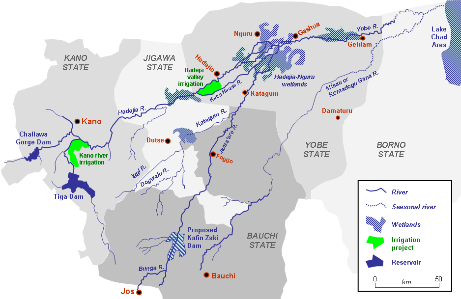
The Challawa Gorge Dam is in Kano State in the Northeast of Nigeria, about 90 km southwest of Kano city. It is a major reservoir on the Challawa River, a tributary of the Kano River, which is the main tributary of the Hadejia River.
Contents
Construction
The Challawa Gorge reservoir project was started by the Water Resources and Engineering Construction Agency of the Kano State Government, and was later handed over to the Federal Government who funded the project. The dam is owned and operated by the Hadejia-Jama’are River Basin Development Authority, a Federal agency.[1]
The dam was built by Julius Berger Nigeria in 1990 - 1992 using rock fill construction. It is 42 m high and 7.8 km in length.[2] The dam has a full storage capacity of 904,000,000 m3. The direct catchment area is 3857 km2.[3]
Hydro power potential
The dam was designed with the potential for hydro power generation in mind, and may have a capacity of 3MW on average - more in the rainy season and less in dry season. However, power would cost considerably more to deliver than current retail prices, and it is not clear how a project to install the generating equipment would be financed.[4]
Issues
The soil in the immediate catchments of the dam has not been stabilized, so the reservoir may be silting up. Silt is also being deposited in the Challawa River, affecting the intake structures of Kano City Water Supply.[5] The dam has disrupted the natural balance along the river. Upstream areas are now subject to flooding while downstream riverine wetlands and croplands have dried out.[6]
A 2002 study noted that while the dam was intended to support irrigation projects, none had been started, although much farmland had been covered by the dam. The water was being used only to supply Kano city. The Challawa dam and the nearby Tiga Dam have also had adverse affects on the downstream Hadejia-Nguru wetlands.[1] Several studies have shown that these dams have delivered negative economic value when their effect on downstream communities was taken into account.[7][8]
References
- ^ a b Etiosa UYIGUE, Society for Water and Public Health Protection. "The Efficiency and Impacts of Dams: A Case Study of the Challawa Gorge Dam". Netherlands Society for Nature and Environment. http://www.snm.nl/pdf/0500_2.3_the_efficiency_and_impact_of_dams_background_paper.pdf. Retrieved 2009-10-02.
- ^ "Challawa Gorge Dam". Nicolas Janberg ICS. http://en.structurae.de/structures/data/index.cfm?id=s0030145. Retrieved 2009-10-02.
- ^ "APPRAISAL OF THE SAFETY OF THE TIGA AND CHALLAWA GORGE DAMS, NIGERIA". World Bank / Lake Chad Basin Commission. March 2002. http://www.iwlearn.net/iw-projects/Fsp_112799467244/reports/lake-chad-basin-project-tiga-and-challawa-gorge-dam-safety-assessment-english.pdf. Retrieved 2009-10-02.
- ^ PROF. ABDU SALIHI, FNSE (11TH - 12th May, 2009). "Hydropower Development at Tiga and Challawa Gorge Dams, Kano State, Nigeria". International Network on Small Hydro Power (IN-SHP). http://www.inshp.org/THE%205th%20HYDRO%20POWER%20FOR%20TODAY%20CONFERENCE/Presentations/Nigeria/Hydropower%20Development%20At%20Tiga%20And%20Challawa%20Gorge%20Dams.pdf. Retrieved 2009-10-02.
- ^ "Challawa Gorge dam". Joint Wetlands Livelihoods project. http://www.jwlnigeria.org/initiativesChallawa.htm. Retrieved 2009-10-02.
- ^ "Challawa Gorge Reservoir". United Nations Environment Program. http://na.unep.net/AfricaLakes/AtlasDownload/PDFs/Africas-Chapter3-2b-Screen.pdf. Retrieved 2009-10-03.
- ^ Edward B Barbier (November 7, 2002). "Upstream Dams and Downstream Water Allocation - The Case of the Hadejia'Jama'are Floodplain, Northern Nigeria". Department of Economics and Finance, University of Wyoming. http://uwacadweb.uwyo.edu/Barbier/Publications/Upstream%20Dams%20and%20Downstream%20Water%20Allocation%20-071703.pdf. Retrieved 2009-10-01.
- ^ David E. Ervin, James R. Kahn, Marie Leigh Livingston (2003). Does environmental policy work?: the theory and practice of outcomes assessment. Edward Elgar Publishing. p. 70ff. ISBN 1840641703.
Adamawa State Kiri DamBauchi State Kafin Zaki DamCross River State Gombe State Kano State Challawa Gorge Dam • Tiga DamKatsina State Jibiya Dam • Zobe DamNiger State Jebba Hydroelectric Power Station • Kainji Dam • Shiroro Hydroelectric Power StationOgun State Oyo State Asejire Reservoir • Ikere Gorge DamSokoto State Bakolori Dam • Goronyo DamZamfara State Gusau DamCategories:- Dams in Nigeria
- Kano State
- Yobe State
Wikimedia Foundation. 2010.