- Dwight Street Historic District
-
Dwight Street Historic District
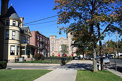
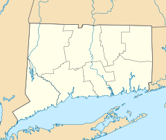

Location: Roughly bounded by Park, N. Frontage, Scranton, Sherman, and Elm Sts., New Haven, Connecticut Coordinates: 41°18′38″N 72°56′23″W / 41.31056°N 72.93972°WCoordinates: 41°18′38″N 72°56′23″W / 41.31056°N 72.93972°W Area: 135 acres (55 ha) Built: 1812 Architect: Multiple Architectural style: Mixed (more than 2 styles from different periods) Governing body: Local NRHP Reference#: 83001281[1] Added to NRHP: September 8, 1983 The Dwight Street Historic District is an irregularly-shaped 135-acre (55 ha) historic district in New Haven, Connecticut. It was listed on the National Register of Historic Places in 1983. In 1983, out of 629 buildings in the district 595 were deemed contributing buildings.[1][2] The historic district includes most of the Dwight neighborhood and several blocks of the northeast corner of the West River neighborhood.
The historic district is an irregularly shaped but "roughly square 20-block commercial and residential neighborhood of modest 19th- and early 20th-century structures lying near the center of New Haven, Connecticut."[2]:2 The district is located immediately west of the center of Downtown New Haven and is generally bounded by Whalley Avenue on the north, Park Street on the east, North Frontage Road on the south, and Sherman Avenue on the west.
The district is distinguished by its "high proportion of Victorian dwellings", including many simplified vernacular versions of Federal, Greek Revival, Italianate, Second Empire, Queen Anne and Colonial Revival styles.[2]:6
Significant contributing buildings in the district include:
- Dwight Place Congregational Church, 1267 Chapel Street, (photo 3)
- Frederick P. Newton House, 128 Dwight Street (photo 17)
- Richmond Building, 246 Park Street (photo 18)
- Malthusheck Piano Manufacturing Building, 216-220 Park Street (photo 20)
- Troup School, Beers Street (photo 21)
References
- ^ a b "National Register Information System". National Register of Historic Places. National Park Service. 2009-03-13. http://nrhp.focus.nps.gov/natreg/docs/All_Data.html.
- ^ a b c Alison Gilchrist and John Herzan (1982). "National Register of Historic Places Inventory-Nomination: West Village / Dwight Street Historic District". National Park Service. http://pdfhost.focus.nps.gov/docs/NRHP/Text/83001281.pdf. and Accompanying 29 photos, from 1979, 1982, 1983
External links
- Dwight Street Historic District, New Haven Preservation Trust website (text adapted from NRHP nomination, plus gallery of 3 photos)]
U.S. National Register of Historic Places Topics Lists by states Alabama • Alaska • Arizona • Arkansas • California • Colorado • Connecticut • Delaware • Florida • Georgia • Hawaii • Idaho • Illinois • Indiana • Iowa • Kansas • Kentucky • Louisiana • Maine • Maryland • Massachusetts • Michigan • Minnesota • Mississippi • Missouri • Montana • Nebraska • Nevada • New Hampshire • New Jersey • New Mexico • New York • North Carolina • North Dakota • Ohio • Oklahoma • Oregon • Pennsylvania • Rhode Island • South Carolina • South Dakota • Tennessee • Texas • Utah • Vermont • Virginia • Washington • West Virginia • Wisconsin • WyomingLists by territories Lists by associated states Other Neighborhoods of New Haven Amity-West Hills · The Annex · Beaver Hills · Cedar Hill · City Point · Dixwell · Downtown · Dwight · East Rock · East Shore · Edgewood · Fair Haven · Fair Haven Heights · The Hill · Long Wharf · Mill River · Newhallville · Prospect Hill · Quinnipiac Meadows · West River · West Rock · Westville · Wooster SquareCategories:- Historic districts in Connecticut
- Historic districts in New Haven, Connecticut
- Neighborhoods in New Haven, Connecticut


Wikimedia Foundation. 2010.