- Miramichi, New Brunswick
-
See Miramichi for other uses, and for information concerning the word's origin.
Miramichi — City — Ritchie Wharf on the Newcastle waterfront in the City of Miramichi.

FlagLocation of Miramichi in New Brunswick

Coordinates: 47°01′21″N 65°30′32″W / 47.0225°N 65.508889°W Country  Canada
Province  New Brunswick
County Northumberland Established 1995 Government – Mayor Gerry Cormier – Governing Body Miramichi City Council – MP Tilly O'Neill-Gordon (C) – Provincial Representatives Serge Robichaud (PC
Robert Trevors (PC)
Bill Fraser (L)Area[1] – Land 179.84 km2 (69.4 sq mi) Highest elevation 31 m (102 ft) Lowest elevation 0 m (0 ft) Population (2006)[1][2] – Total 18,129 – Density 100.8/km2 (261.1/sq mi) – Change 2001-06  2.0%
2.0%– Census Ranking 213 of 5,008 Time zone AST (UTC-4) – Summer (DST) ADT (UTC-3) Postal code(s) E1N, E1V Area code(s) 506 Dwellings 7,930 Median Income* $43,872 CDN NTS Map 021P03 GNBC Code DBEDJ Website www.miramichi.org Miramichi (2006 population: 18,129) is the largest city in northern New Brunswick, Canada.[3] It is situated at the mouth of the Miramichi River where it enters Miramichi Bay. The Miramichi River valley is the longest valley in New Brunswick.
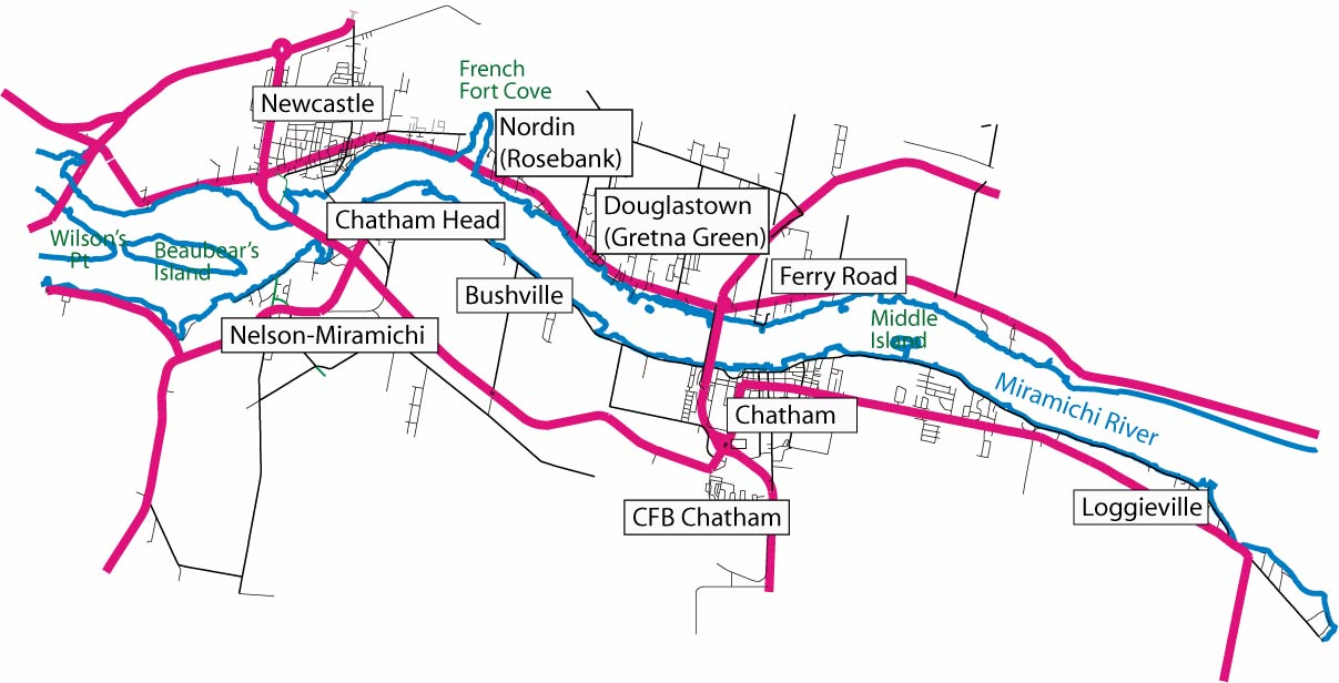
The city of Miramichi was formed in 1995 through the forced amalgamation of two towns, Newcastle and Chatham, and several smaller communities, including Douglastown, Loggieville, and Nelson.
History
Mi'kmaq and French communities (before 1765)
Long prior to European settlement, the Miramichi region was home to members of the Mi'kmaq first nation. For the Mi'kmaq, Beaubears Island, at the junction of the Northwest and Main Southwest branches of the Miramichi River was a natural meeting point.
Following the European discovery of the Americas, the Miramichi became part of the French colony of Acadia. About 1648, Nicolas Denys, Sieur de Fronsac, established a fort and trading post, Fort Fronsac, on the Miramichi. This establishment was apparently constructed "on the North side of the Miramichi, at the forks of the river". According to W.F.Ganong, a Recollet Mission was established in 1686 on the Miramichi "in Nelson", "probably near Beaubear's Island".[4][5][6]
Nicolas Denys' son, Richard Denys, was placed in charge of the fort and trading post, and in 1688 Richard states, "Miramichi is the principal place of my residence", and describes his establishment as including about a dozen French and more than 500 Indians. In 1691 Richard died at sea; the post declined.[4][5][6][7]
By about 1740 French villages were well established on Miramichi Bay at Bay du Vin and Neguac. In the current city of Miramichi, a larger village existed at Canadian Point, and a town comprising 200 houses, a chapel, and provision stores occupied "Beaubear's Point". The French maintained batteries of guns at the east end of Beaubears Island and at French Fort Cove.[8]
French and Indian War
 Camp d'Espérance Memorial at Wilson's Point (IR Walker 2007)
The French and Indian War erupted in 1754. During the war many Acadian homes were destroyed by the British, and their residents were deported (see the Expulsion of the Acadians).
In 1757 the French general, Charles Deschamps de Boishébert et de Raffetot attempted to evade British troops in the St. John Valley and the Bay of Fundy, by leading 900 French refugees up the northeast coast of New Brunswick to Miramichi, establishing a camp, "Camp de l’Espérance", on Beaubears Island. Over 200 of the refugees died at the camp. During the war, the camp was protected by a battery of French cannons at French Fort Cove. After the Siege of Louisbourg (1758), Boishebert led a group of Acadians from St. Peter's, Nova Scotia to Miramichi.
On 13 August 1758 French officer Boishebert left Miramichi with 400 soldiers, including Acadians from Port Toulouse, for Fort St George (Thomaston, Maine). His detachment reached there on 9 September but was caught in an ambush and had to withdraw. They then went on to raid Friendship, Maine, where British settlers were killed and others taken prisoner. [9] This was Boishébert’s last Acadian expedition. From there, Boishebert and the Acadians went to Quebec and fought in the Battle of Quebec (1759). [10]
In September 1758 Colonel James Murray reported spending two days in Miramichi Bay during the Gulf of St. Lawrence Campaign (1758) looking unsuccessfully for Acadians, but destroying anything he found. This included burning the first stone church built in New Brunswick (at the site of the present-day community of Burnt Church).[11] Murray didn't sail as far west as Beaubear's Island.Most of the surviving Beaubear's Island refugees soon left the Miramichi, seeking refuge in Quebec. Some Acadians, however, remained and escaped British attempts at deportation. They eventually established (or re-established) a host of small Acadian communities along the northern and eastern coasts of present-day New Brunswick.[12][13]
Scottish, Loyalist and Irish immigration (1765-1850)
The French were defeated at Quebec (1759) and Montreal (1760), and the remaining Miramichi settlement was subsequently burned to the ground by British Commodore John Byron (Foul-Weather Jack) in 1760. The French North American colonies (apart from Saint Pierre and Miquelon) were ceded to the British in the 1763 Treaty of Paris. The Miramichi thus became a part of the British colony of Nova Scotia, and later New Brunswick. Benjamin Marston, a surveyor and the first sheriff, reported in 1785 that "a considerable French Village" had existed on Wilson's Point (adjacent to Beaubear's Island, the present-day site of the Enclosure).[14]
Although they were clearly preceded by the Mi'kmaq and Acadian peoples, credit for the first permanent white settlement at Miramichi is often granted to Scottish settlers, led by William Davidson. William Davidson (a.k.a. John Godsman) and John Cort had obtained a large grant encompassing much of the Miramichi region in 1765, and promoted the area in both Scotland and New England as a new home to potential settlers.
American Revolution
Battle at Miramichi (1779)
In the beginning of the American Revolution the Mi’kmaq and Maliseet were supportive of the Americans against the British. They participated in the Maugerville Rebellion and the Battle of Fort Cumberland in 1776. Three years later, in June 1779, Mi’kmaq in the Miramichi attacked and plundered some of the British in the area. The following month, British Captain Augustus Harvey, in command of the HMS Viper arrived in the area and battled with the Mi’kmaq. One Mi’kmaq was killed and 16 were taken prisoner to Quebec. The prisoners were eventually brought to Halifax, where they were later released upon signing an oath of allegiance to the British Crown on 28 July 1779.[15]
After the battle, Davidson temporarily found refuge along the St. John River. A subsequent treaty signed 22 September 1779 ensured a more peaceful coexistence. Following the American Revolution some loyalist families moved to Miramichi. Davidson's original grant was revoked, and competition for the best lands escalated tensions between the early Scottish and new loyalist settlers. In the 1840s, the Great Irish Famine led to the last large influx of settlers, mostly settling on the south side of the river in the former town of Chatham. By this time, the best lands were already occupied by earlier Scottish, Loyalist and Acadian immigrants.
Industry and politics (1765-1850)
 Rankin House, former home of Miramichi lumber baron Alexander Rankin at Douglastown (IR Walker 1983)
Although subsistence farming constituted one part of the new settlement's economy, the thin, acid soils of the Miramichi were not conducive to agriculture; thus, the lumber industry and Atlantic salmon fishery were the mainstays. A shipbuilding industry was established by Davidson in 1773, largely to facilitate overseas lumber exports, including masts for the British navy, and to provide winter employment for the men. Davidson's first ship, "Miramichi", was lost with her cargo off the Spanish coast.
Miramichi benefited greatly from the Napoleonic wars and American independence, as Britain became dependent on its remaining North American colonies, including New Brunswick, for lumber. However, the Great Miramichi Fire of 1825, the advent of steel-hulled ships, and perhaps over-cutting of eastern white pine, would eventually contribute to a long-term decline in the area's economy. The Miramichi Fire burnt almost 1/4 of New Brunswick's forest, and consumed most of the buildings along the northern side of the river. Only 12 buildings remained in Newcastle.
The towns of Newcastle and Chatham developed a long history of rivalry, including a small "war" fought between the communities ("the fighting election of 1843"). The 1843 election was fought on a political level between John T. Williston of Chatham (supported by local entrepreneur Joseph Cunard of Chatham, brother of Samuel Cunard) and John Ambrose Street of Newcastle (backed by the prominent lumber baron, Alexander Rankin of Douglastown). The Rankin and Cunard factions literally fought the election in the streets of Newcastle and Chatham with sticks, stones, coal and other missiles.
The age of rail (1875-1950)
In 1875 the region's largest construction project in history was completed when the federal government's Intercolonial Railway (ICR) opened between Moncton and Campbellton. The following year it would link Halifax with Rivière-du-Loup and the Canadian railway network. One of the biggest geographic obstacles presented in the project was the crossing of the Miramichi River. Surveyors deemed the ideal location for bridging to be at the upper reaches of tidewater between Nelson and Newcastle, crossing the Southwest Miramichi, then a short section of land at Derby, followed by the Northwest Miramichi. The combined length of these bridges would be among the largest constructed to date in Canada (surpassed only by the Victoria Bridge in Montreal) and were the first bridges over the Miramichi River, revolutionizing transport in the region.
The ICR bypassed Chatham by running through Newcastle and then on to the north and west. Within a decade, the Canada Eastern Railway was built to link Chatham with Fredericton, along the length of the Southwest Miramichi River valley. In 1904, the Canada Eastern was purchased by the ICR. In 1915, the ICR became part of Canadian Government Railways and 3 years later in 1918 it became part of the Canadian National Railways (CNR).
 Stothart's Mercantile in downtown Newcastle (IR Walker 1974)
CNR operated express passenger trains along the main line from Halifax to Montreal via Newcastle, most notably the Ocean Limited, along with various local trains to Fredericton, Moncton and Campbellton. The Dungarvon Whooper provided passenger service along the Canada Eastern Railway from Newcastle to Fredericton. The ports and railways serving Newcastle and Chatham burgeoned with activity as the 19th century lumber industry gave way to the 20th century developments in pulp and paper, and mining.
20th century industry and politics
As the shipbuilding, masting and lumber industries waned, pulp and paper production eventually replaced lumber exports as the mainstay of the area's economy. A valuable sports fishery developed, attracting "sports" initially from adjacent New England, and subsequently from all parts of the world. In the mid 20th century, an air force base, CFB Chatham, became the cornerstone of Chatham's economy. The discovery of base metal deposits and the development of Heath Steele Mines, 60 km to the northwest, allowed Newcastle's economy to diversify and strengthen through the 1960s. The mine and airforce base had both closed by 1999 as the mine's ore body was depleted, and with the collapse of the cold war. The forest industry is the dominant player in the city's economy today.
In the 20th century the rivalry between Newcastle and Chatham continued, expressed chiefly through sports, politics, and in competition for businesses and government largesse. In 1994 then Premier Frank McKenna (the Member of the Legislative Assembly for Chatham) developed and implemented a plan for merging the communities. The amalgamation of the former towns and villages to form the City of Miramichi was controversial at the time, and remains so today, due to the strong identities that each of the communities possessed. The 1995 amalgamation of the communities served to limit this rivalry, giving the region a larger and more united voice in promoting the region.[16]
 Communities amalgamated in 1995 to form the City of Miramichi
Demographics
Census Population Chatham Newcastle 1871 3,000 1,500 1901 4,868 2,507 1911 4,666 2,945 1921 4,506 3,507 1931 4,017 3,383 1941 4,082 3,781 1951 5,223 4,248 1961 7,109 5,236 1971 7,833 6,460 1981 6,779 6,284 1991 6,544 5,711 Miramichi 2001 18,508 2006 18,129 Population trend[17]
Census Population Change (%) 2006 18,129 2.0%2001 18,508 3.8%1996 19,241 9.1%1991 21,165 N/A Mother tongue language (2006)[1]
Language Population Pct (%) English only 15,935 89.25% French only 1,470 8.23% Other languages 330 1.85% Both English and French 120 0.67% According to the Statistics Canada 2001 census,[18] there were 18,508 people residing in Miramichi. 48.1% of residents were male and 51.9% were female.
Children under five accounted for approximately 5.0% of the resident population. This compares with 5.6% for Canada overall. In mid-2001, 15.5% of the resident population of Miramichi were of retirement age (65 and over for males and females) compared with 13.2% in Canada. The median age was 39.9 years of age, comparing to 37.6 years of age nationally.
In 2001, 97.6% of the population were born in Canada; 89.4% claimed "English only" as the "language(s) first learned and still understood", whereas 8.8% indicated French, and 0.7% indicated "both English and French". The population was 61.8% Roman Catholic, and 33.3% Protestant. 3.8% reported no religious affiliation.
- Source: Statistics Canada 2001 Census[18]
Climate
Miramichi enjoys a cool, moist climate with a mean annual temperature of 4.7 °C (40.5 °F).[19] The January mean temperature is −10.7 °C (12.7 °F),[19] and the mean July temperature is 19.2 °C (66.6 °F).[19] Proximity to the Gulf of St. Lawrence tends to moderate the winter climate, but Arctic air sometimes penetrates into the area during winter. The coldest recorded temperature is −35 °C (−31.0 °F)[19] (2 February 1962). Summers are warm and sunny; the warmest recorded temperature is 37.8 °C (100.0 °F)[19] (August 12, 1944). The city averages about 1,115 mm (43.9 in)[19] of precipitation per year, with about 310.1 cm (122.1 in)[19] falling as snow. Miramichi winters are sunnier than almost anywhere else in Canada, averaging 120 hours of bright sunshine in January. Miramichi averages 250.5[19] hours of bright sunshine in July.
Climate data for Miramichi Month Jan Feb Mar Apr May Jun Jul Aug Sep Oct Nov Dec Year Record high °C (°F) 13.6
(56.5)15.3
(59.5)22.8
(73.0)28.1
(82.6)35.3
(95.5)36.7
(98.1)36.7
(98.1)37.8
(100.0)33.1
(91.6)27.8
(82.0)21.1
(70.0)15.6
(60.1)37.8
(100.0)Average high °C (°F) −4.8
(23.4)−3.2
(26.2)2.1
(35.8)8.2
(46.8)16.3
(61.3)22.3
(72.1)25.3
(77.5)24.4
(75.9)19
(66)12
(54)4.7
(40.5)−1.9
(28.6)10.4 Average low °C (°F) −16.4
(2.5)−14.9
(5.2)−8.7
(16.3)−2
(28)3.7
(38.7)9.5
(49.1)13.1
(55.6)12.1
(53.8)6.9
(44.4)1.2
(34.2)−3.8
(25.2)−11.9
(10.6)−0.9 Record low °C (°F) −34.5
(−30.1)−35
(−31)−31.4
(−24.5)−17.2
(1.0)−8.9
(16.0)−2.2
(28.0)2.8
(37.0)0.6
(33.1)−5
(23)−8.9
(16.0)−20.4
(−4.7)−30
(−22)−35
(−31.0)Precipitation mm (inches) 95.5
(3.76)72.1
(2.839)94.3
(3.713)89.2
(3.512)97.7
(3.846)89.3
(3.516)106.1
(4.177)89.2
(3.512)85.5
(3.366)97.4
(3.835)99.4
(3.913)99.4
(3.913)1,115
(43.9)Source: Environment Canada[19] Economy
The Miramichi area’s economy is primarily focused on forests, mining and fishing. Other sectors include: tourism, customer contact centres, manufacturing and provincial and federal government. The service sector is the largest employer. The region has recently experienced the closure of several wood mills causing many residents to migrate west.
Transportation
- Roads
 Centennial Bridge
Miramichi has good highway connections to other major centres in New Brunswick offered via Highways 8 (west to Fredericton; north to Bathurst and Campbellton) and 11 (south to Moncton, Prince Edward Island and Nova Scotia). The Plaster Rock – Renous highway (Route 108) offers the quickest connection to major centres in Quebec, Upper Canada, and points west.
For years, the only bridge at Miramichi was a narrow, historic crossing, the Morrissy Bridge, at Newcastle. Ferry service facilitated crossings at Chatham and Loggieville. In the late 1960s the Centennial Bridge was completed at Chatham, greatly improving north-south transit across the river. The Miramichi Bridge at Newcastle opened in the late 1990s.
- Water
The towns of Chatham and Newcastle were formerly important ports for northeastern New Brunswick. Dredging, however, was necessary to maintain a deep enough channel for most ships to cross between the barrier dune islands at the mouth of Miramichi Bay. Ocean-going ships entering the port must have a shallow draft, and must navigate the ancient, meandering course of the drowned Miramichi River channel through the inner Bay.
- Rail
The New Brunswick East Coast Railway (NBECR), formerly part of the Canadian National (CN) Railway mainline, and the earlier Intercolonial Railway passes through Miramichi. Supplementing NBECR's freight capacity, Via Rail offers passenger service on this line at the Miramichi railway station via the Ocean train to Montreal and Halifax.
- Air
Miramichi is located within a 90 minute drive of two international airports (Fredericton International Airport, Greater Moncton International Airport) with scheduled domestic and international flights. In addition the Miramichi Airport Commission operates the Miramichi Airport (YCH) on the former site of CFB Chatham.
Arts and culture
Roots
As in other regions of the Maritimes, Miramichi culture is firmly grounded in the Mi'kmaq, Acadian, Scottish, and Irish traditions of the region's founding population, particularly in the fishing, sailing and lumbering industries. Every bend in the rivers, from Push and Be Damned Rapids to the Turnip Patch has a distinctive name. These roots and the lives of their ancestors provided inspiration for the novels of local author David Adams Richards, the tales and folklore of Herb Curtis, and the fiction and non-fiction of Chatham-born writer Raymond Fraser. Local young adult author Valerie Sherrard's first historical novel, Three Million Acres of Flame, deals with the 1825 Miramichi Fire, one of the largest recorded land fires in North American history.
Festivals
Local festivals which celebrate Miramichi culture, and the ancestral roots of the original settlers include:
- Miramichi Folk Song Festival
- Annual Pow-wows hosted on the nearby Eel Ground First Nation and Metepenagiag Mi'kmaq Nation
- La Fête nationale des Acadiens—Acadian Day
- Miramichi Scottish Festival
- Canada's Irish Festival on the Miramichi
- Miramichi Fiddle Festival
Other local festivals include:[20]
- Canada Days Festival
- Miramichi Rock 'n Roll Festival
- Miramichi Salmon Classic
- Miramichi Exhibition
- Miramichi Valley High School Hockey Fall Classic
Proper diction
Miramichiers speak English, though some residents exhibit a vernacular, seemingly a derivative of Maritime English, not readily understood by outsiders. A small part of this language has been captured in Herb Curtis' 1991 book, Look What the Cat Drug In: A Miramichi Dictionary and Doug Underhill's 1996 City of Miramichi: An Interpretive Guide.
Recreation
The city offers a full range of summer and winter sports programs and facilities, including recreation centres, swimming pools, a golf course, and rinks for skating, curling and ice hockey. The city, however, is best known as a haven for outdoor sport enthusiasts. The river offers gently meandering, and challenging whitewater opportunities for canoe and kayak, and superb angling for Atlantic Salmon and brook trout. About one-half of the sport catch of Atlantic salmon in North America are landed on the Miramichi River and its tributaries. The warm waters of Miramichi Bay offer an ideal setting for sailing enthusiasts during summer. The snowy winters are welcomed by cross-country skiers and snowmobilers. An extensive network of trails is available for hiking, cycling, birding, skiing, and snowmobiling.
Sports Teams
Miramichi is home to numerous sports teams The city has 2 hockey teams, the Miramichi Timberwolves of the Maritime Junior Hockey League. The team plays out of the Miramichi Civic Centre. The other team, th Miramichi Phantoms who play out of the Lord Beaverbrook Arena. The city's baseball team, the Chatham Ironmen play in the New Brunswick Senior Baseball League at Ironmen Feild. They are the winners of the 1995 Canadian Senior Baseball Nationals.
Education
Miramichi is served by 11 public schools operated by the New Brunswick Department of Education. Post-secondary education, including a distance education component from the University of New Brunswick, is offered primarily through the Miramichi campus of New Brunswick Community College.
Public schools
New Brunswick School District 11 (French):
- École Carrefour Beausoleil (K-12)
New Brunswick School District 16 (English):
- High Schools:
- James M. Hill Memorial High School
- Miramichi Valley High School
- Middle Schools:
- Dr. Losier Middle School
- Harkins Middle School
- Millerton Elementary & Junior High School
- Elementary Schools:
- Croft Elementary School
- Gretna Green Elementary School
- Harkins Elementary School
- Ian Baillie Primary School
- Nelson Rural School
- St. Andrew’s Elementary School
- Napan Elementary School
- Millerton Elementary & Junior High School
Private schools
- Karasek School Of Dance
- L.F.M. Memorial Academy
- Miramichi Taekwondo Academy
Post-secondary
- Public:
- New Brunswick Community College, Miramichi Campus
- Private:
- Academy of Learning Career and Business College
Prominent citizens, past and present
 Beaverbrook House, formerly the Old Manse Library, and earlier the boyhood home of Max Aitken, Lord Beaverbrook, in Newcastle (IR Walker 1983)
- Max Aitken, 1st Baron Beaverbrook, Business tycoon, politician, writer and philanthropist
- Richard Bedford Bennett, 1st Viscount Bennett, 11th Prime Minister of Canada
- Matilda Murdoch, O.N.B, C.M., legendary fiddle player, composer, teacher - Member of the Order of Canada and Order of New Brunswick
- Susan Butler, Folk singer and recipient of the Order of Canada
- Martin Cranney Pioneer Irish leader on the Miramichi
- Joseph Cunard, Politician, shipbuilder and businessman. Former MLA. Brother of Samuel Cunard
- William Davidson, Pioneer, businessman, shipbuilder, politician. MLA.
- Richard Denys, Pioneer fur-trader, son of Nicolas Denys (fur-trader)
- Yvon Durelle, British Empire champion boxer
- Frances Fish, lawyer, politician
- George P. Burchill, Shipbuilding and lumber operations, Senator of Canada 1945-1977
- Raymond Fraser, Author and poet
- James Gilmour (Miramichi lumber baron)
- Richard Hutchison, Politician and businessman. Former MLA, MP.
- W.S. Loggie, Politician and businessman. Former MLA, MP.
- Louise Manny, Folklorist and historian
- Frank McKenna, Businessman and politician. 27th Premier of NB, former Ambassador to the US
- George Roy McWilliam longtime Member of Parliament.
- Peter Mitchell, Politician, Father of Confederation. Former Premier of NB (as a British Province) and MP.
- Joseph Leonard O'Brien, Politician and businessman. Former Lieutenant-Governor, MLA, MP of NB.
- Alexander Rankin, Politician and businessman. Former MLA.
- David Adams Richards, Award winning writer
- James Rogers (bishop)
- Joseph Russell (shipbuilder)
- Brent Sherrard, author
- Valerie Sherrard, Award winning author
- Jabez Bunting Snowball, Politician and businessman. Former Lieutenant-Governor, MP of NB.
- John Ambrose Street, Lawyer and politician. MLA, Attorney General.
- Lemuel John Tweedie, Politician and Lawyer, Former Premier and Lieutenant-Governor of NB.
- Michael Whelan, Poet
Tourism
 French Fort Cove (IR Walker 2007)
Miramichi River
The Miramichi River is the centre of all activity. The communities that compose the city line its banks.
Beaubears Island
Beaubears Island, located in the middle of the Miramichi River between Newcastle and Nelson-Miramichi, is home to two National Historic Sites, Boishébert National Historic Site of Canada and Beaubears Island Shipbuilding National Historic Site of Canada, J. Leonard O'Brien Memorial. The island is recognized for its role in the Acadian Expulsion, and as the former home of a major shipbuilding industry.[21]
Enclosure Campground
Also known as Wilson's point, this location marks the area of Miramichi that was first developed by settlers. It, along with Beaubear's Island, was involved in the Acadian Expulsion. It now serves as a campground and contains kilometres of walking trails.
French Fort Cove
French Fort Cove is a nature park located between Newcastle and Nordin. The park contains regular and advanced walking trails, canoeing, kayaking, paddle-boats, a children's playground, and an ice-cream shop. The park holds many events and activities during the summer.
It is the former site of a gristmill, lumbermill and shipyard. It is also the former location of a rock quarry which was used to build many local buildings and the Langevin Block of the Parliament Hill, among others.
It is the setting for the local legend of the Headless Nun.[22]
Middle Island
 Irish Memorial on Middle Island (IR Walker 2007)
Middle Island was used as a quarantine station when, in 1847, typhus and scarlet fever spread throughout the ship Looshtauk as it crossed the Atlantic Ocean. Of the 462 passengers on board, at least 146 people died en route and 96 died while in quarantine.[23] Initially those who died on the island were buried in caskets, but as the death toll continued to rise personal resting places could no longer be an option. This resulted in large mass graves being placed on the island. Some of these graves were discovered as recently as 1996.
Many people are able to trace their family roots back to the journey taken by the Looshtauk.
The island now serves as a tourist location and memorial.
Rankin House
Alexander Rankin and James Gilmour came to the area in 1812 to establish a lumber and shipbuilding enterprise (Gilmour, Rankin & Co.) at Douglastown (then known as Gretna Green). Rankin House was constructed in 1837 as the home of Alexander Rankin.
Rankin House is now a museum containing a collection of objects relating to early life in New Brunswick. It is located in Douglastown on the King George Highway.[24]
Miramichi Natural History Museum
The Miramichi Natural History Museum (c. 1908 to 1909) is on the Canadian Register of Historic Places.[25]
Ritchie Wharf
Ritchie Wharf is a park located on the waterfront of Newcastle-Miramichi. It is the location of many events that take place on the river, and is often the location of choice for local musicians.
Its boardwalk is lined with restaurants, art galleries, and souvenir shops, and it is also the location of a tourist information centre. In addition, there is a children's playground with a small water park.
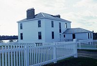
Marine (Seamen's) Hospital
 Marine Hospital (IR Walker 2008)
The Marine Hospital was built in 1830-1831, and was used to provide care to members of the shipping community involved in the lumber trade. It is the oldest surviving marine hospital in Canada, and now serves as a hall for a local church and the general public. It last opened its door to patients in 1921, and was commemorated by the Historic Sites and Monuments Board of Canada in September 2000.[26]
Shopping
Miramichi is home to 2 downtown shopping districts; The Historic Downtown Chatham and Downtown Newcastle shopping districts each have numerous boutiques. The main shopping district is in the former town of Douglastown. The shopping district includes a large enclosed shopping mall, multiple strip malls and numerous other stores and businesses. It is anchored by; Walmart Canada, Zellers, Canadian Tire, Hart Stores, Sobeys, Shoppers Drug Mart, Sport Chek and Staples Business Depot.
Twin city
 Monaghan, Ireland. In 1999 Miramichi was twinned with the County Monaghan in Ireland. Monaghan, a county of some 55,000 people, is located in the north-east of the Republic of Ireland on the border with Northern Ireland. This link denotes the strong ancestral bonds between Ireland and New Brunswick and Canada generally. Each year delegations from Monaghan and Miramichi exchange visits.
See also
Founding communities:
- Nelson
- Chatham
- Douglastown
- Loggieville
- Newcastle
Other:
References
- ^ a b c 2006 Statistics Canada Community Profile: Miramichi, New Brunswick
- ^ Statistics Canada Population and dwelling counts, for Canada and census subdivisions (municipalities), 2006 and 2001 censuses - 100% data
- ^ New Brunswick Provincial Archives - Miramichi
- ^ a b English, E.J. (2002) Nelson and its Neighbours: 300 years on the Miramichi, 2nd Ed., Earl J. English, Miramichi
- ^ a b Davidson, W.H. (1947) An account of the life of William Davidson, otherwise John Godsman, of Banffshire and Aberdeenshire in Scotland and Miramichi in British North America. Publ. New Brunswick Museum, Historical Studies No. 6.
- ^ a b Davidson, W.H. (1966) William Davidson 1740-1790. North Shore Leader, Newcastle
- ^ Beaubear's Island National Historic Site http://www.breadnmolasses.com/2004/atlanticarts/id73.html
- ^ Cooney, R. (1832) A compendious history of the northern part of the province of New Brunswick and of the District of Gaspé in Lower Canada. Joseph Howe, Halifax
- ^ The history of the state of Maine: from its first discovery, A. D ..., Volume 2 By William Durkee Williamson, p. 333
- ^ Phyllis E. Leblanc Dictionary of Canadian Biography Online; Cyrus Eaton's history, p. 77
- ^ John Faragher. Great and Noble Scheme. Norton. 2005. p. 404
- ^ Charlotte Taylor: Her Life and Times http://www3.bc.sympatico.ca/charlotte_taylor/Folder1/Destruction_of_Burnt_Church.htm.
- ^ Miramichi, New Brunswick http://www.acadian-home.org/miramichi-history.html
- ^ Boishébert and Beaubears Island Shipbuilding National Historic Site of Canada, J. Leonard O'Brien Memorial https://www.pc.gc.ca/lhn-nhs/nb/boishebert/natcul/natcul2_e.asp
- ^ http://www.biographi.ca/009004-119.01-e.php?id_nbr=2486; Sessional papers, Volume 5 By Canada. Parliament July 2 - September 22, 1779; Wilfred Brenton Kerr. The Maritime Provinces of British North America and the American Revolution. p. 96
- ^ The Canadian Encyclopedia
- ^ Statistics Canada: 1996, 2001, 2006 census
- ^ a b [1]: Statistics Canada. 2002. 2001 Community Profiles. Released June 27, 2002. Last modified: 2005-11-30. Statistics Canada Catalogue no. 93F0053XIE.
- ^ a b c d e f g h i "Canadian Climate Normals 1971-2000". Environment Canada. http://www.climate.weatheroffice.ec.gc.ca/climate_normals/results_e.html?Province=ALL&StationName=Miramichi&SearchType=BeginsWith&LocateBy=Province&Proximity=25&ProximityFrom=City&StationNumber=&IDType=MSC&CityName=&ParkName=&LatitudeDegrees=&LatitudeMinutes=&LongitudeDegrees=&LongitudeMinutes=&NormalsClass=A&SelNormals=&StnId=6140&&autofwd=1. Retrieved 2009-07-24.
- ^ City of Miramichi, New Brunswick—Community, Business & Tourism
- ^ "Beaubears Island", by Joyce LeBlanc. Retrieved August 21, 2006.
- ^ "Story Quarry", French Fort Cove Nature Park. Retrieved August 21, 2006.
- ^ "Middle Island Irish Historical Park"[dead link], Bread n' Molasses. Retrieved August 16, 2006.
- ^ "Rankin House", Miramichi Memories. Retrieved August 24, 2006.
- ^ Canadian Register of Historic Places.
- ^ "Historic Sites", City of Miramichi. Retrieved August 24, 2006.
External links
- The City of Miramichi's Official Website
- Beaubear's Island
- French Fort Cove
- Historic Middle Island
- Miramichi Landings

Bathurst Neguac 
 Miramichi

Blackville Rogersville Saint-Louis-de-Kent
Coordinates: 47°01′21″N 65°30′32″W / 47.0225°N 65.50889°WSubdivisions of New Brunswick Subdivisions Cities Categories:- Miramichi, New Brunswick
- Populated coastal places in Canada
- Communities in Northumberland County, New Brunswick
- Conflicts in Nova Scotia


Wikimedia Foundation. 2010.