- Chingleput District (Madras Presidency)
-
Chingleput district was a district in the Madras Presidency of British India. It covered the area of the present-day districts of Kanchipuram and Tiruvallur and parts of Chennai city. It was sub-divided into six taluks with a total area of 3,079 square miles (7,970 km2). The town of Saidapet (now a neighbourhood in the city of Chennai), and later, Chingleput (now known as Chengalpattu) served as the administrative headquarters of the district.
Contents
History
Excavations made by Robert Bruce Foote indicate that the region was inhabited in the Stone age. During the first millennium B. C., Chingleput district might have been a part of the Andhra kingdom. The Pallavas with their capital at Kanchi came to power in about 500 A. D. When the Pallava kingdom began to decline, the region was conquered by the Western Gangas in about 760 A. D. Chingleput was ruled by the Rashtrakutas, Cholas and the Kakatiyas of Warangal until the 13th century AD when it fell to the Delhi Sultanate. The region was conquered by the Vijayanagar Empire which ruled the region from 1393 till 1565 and from 1565 till 1640 as the kingdom of Chandragiri. The region was annexed by the Mughals in 1687 and was later conquered by the Nawab of the Carnatic. In 1763, Chingleput was ceded to the British East India Company by Mohammad Ali, the then Nawab of the Carnatic. It was the site of the Carnatic Wars and was frequently taken by Tipu Sultan during the last years of the 18th century. In 1801, the Nawab of the Carnatic, finally, relinquished complete sovereignty over the region to the British East India Company.
Taluks
Chingleput district was made of eight taluks:
- Chingleput (Area: 436 square miles (1,130 km2); Headquarters:Chingleput)
- Conjeevaram (Area: 514 square miles (1,330 km2); Headquarters:Conjeevaram)
- Madurantakam (Area: 696 square miles (1,800 km2); Headquarters:Madurantakam)
- Ponneri (Area: 347 square miles (900 km2); Headquarters:Ponneri)
- Saidapet (Area: 342 square miles (890 km2); Headquarters:Saidapet)
- Tiruvallur (Area: 744 square miles (1,930 km2); Headquarters:Tiruvallur)
Administration
The district was sub-divided into three sub-divisions each under the charge of a Deputy Collector:
- Chingleput sub-division: Chingleput, Madurantakam and Conjeevaram taluks
- Saidapet sub-division: Saidapet taluk
- Tiruvallur sub-division: Tiruvallur and Ponneri taluks.
As of 1901, the district had two municipalities Conjeevaram and Chingleput.
Demographics
Historical populations Year Pop. ±% 1871 938,184 — 1881 981,381 +4.6% 1891 1,202,928 +22.6% 1901 1,312,122 +9.1% Sources: - Imperial Gazetter of India, Volume 10. Clarendon Press. 1908.
As of 1901, Chingleput had a total population of 1,312,222. 96 percent of the population were Hindus while the rest where Christians and Muslims. About three-fourths of the people spoke Tamil as their mother tongue the remainder spoke Telugu. Due to its proximity to Madras city, there were also large numbers of Europeans in the district.
Sources
- Imperial Gazetter of India, Volume 10. Clarendon Press. 1908.
Tiruvallur district District Headquarters 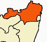
Country State Region Divisions Ponneri • Thiruvallur • TiruttaniTaluks Ambattur · Gummidipoondi · Madhavaram · Pallipattu · Ponneri · Poonamallee · Thiruttani · Tiruvallur · UthukkottaiRevenue blocks Ellapuram • Gummidipoondi • Kadambathur • Minjur • Pallipattu • Poonamallee • Poondi • Pulal • R.K.Pet • Sholavaram • Tiruvallur • Tiruttani • Thiruvalangadu • VillivakkamMunicipalities Ambattur · Avadi · Kattivakkam · Madhavaram · Maduravoyal · Manali · Poonamallee · Thiruttani · Tiruverkadu · Tiruvottiyur · Tiruvallur · Valasaravakkam
History Pallavas · Medieval Cholas · Later Cholas · Later Pandyas · Delhi Sultanate · Madurai Sultanate · Vijayanagar Empire · Carnatic Kingdom · Company Raj · British RajPlaces of interest Ennore Port · Heavy Vehicles Factory, Avadi · Madhavaram Milk Colony · Pulicat Lake Bird Sanctuary · Siva Temple, Tiruvottiyur · Thiruthani Murugan Temple · ThiruevvulCategories:

Wikimedia Foundation. 2010.