- Chipping Sodbury railway station
-
Chipping Sodbury 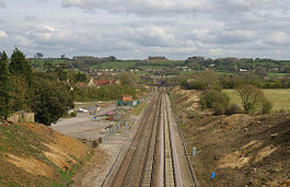
The remains of the station viewed from the west. Location Place Chipping Sodbury Area South Gloucestershire Coordinates 51°31′56″N 2°22′44″W / 51.5323°N 2.379°WCoordinates: 51°31′56″N 2°22′44″W / 51.5323°N 2.379°W Grid reference ST736815 Operations Original company Great Western Railway Pre-grouping GWR Post-grouping GWR History 1 July 1903 Opened 3 April 1961 Closed Disused railway stations in the United Kingdom Closed railway stations in Britain
A B C D–F G H–J K–L M–O P–R S T–V W–ZChipping Sodbury railway station was a railway station on the South Wales Main Line serving the town of Chipping Sodbury in Gloucestershire.
The station opened on 1 July 1903, and closed on 3 April 1961.[1]
References
External links
Closed railway stations in eastern Gloucestershire Cheltenham and Great Western Union Railway Tetbury Road · Chalford · St Mary's Crossing Halt · Brimscombe · Brimscombe Bridge Halt · Ham Mill Halt · Bowbridge Crossing Halt · Downfield Crossing Halt · Cashes Green Halt · Ebley Crossing Halt · Churchdown · Cheltenham Spa Malvern Road · Cheltenham Spa St. JamesCirencester Branch Line Tetbury branch line Jackament's Bridge Halt · Rodmarton Platform · Church's Hill Halt · Culkerton · Trouble House Halt · TetburyMidland and South Western Junction Railway South Cerney · Cirencester Watermoor · Foss Cross · Chedworth Halt · Withington (Glos) · Andoversford and DowdeswellEast Gloucestershire Railway Lechlade · FairfordBanbury and Cheltenham Direct Railway Stow-on-the-Wold · Bourton-on-the-Water · Notgrove · Andoversford Junction · Charlton Kings · Cheltenham LeckhamptonOxford, Worcester and Wolverhampton Railway Honeybourne Line Cheltenham High Street Halt · Bishops Cleeve · Gretton Halt · Hayles Abbey Halt · Laverton Halt · Willersey Halt · Weston-sub-EdgeBristol and South Wales Union Railway Ashley Hill · Horfield · Filton · Filton Junction · Pilning Low Level · Cross Hands Halt · New Passage Halt · New Passage · New Passage PierBristol and Gloucester Railway St Philip's · Fishponds · Staple Hill · Mangotsfield · Wickwar · Charfield for Wootton-under-Edge · Berkeley Road · Coaley · Frocester · Stonehouse Bristol Road · Haresfield · Gloucester EastgateMangotsfield and Bath Branch Line Thornbury Branch Line Sharpness Branch Line Berkeley · SharpnessDursley and Midland Junction Railway Stonehouse and Nailsworth Railway Birmingham and Gloucester Railway Tewkesbury and Malvern Railway Categories:- Disused railway stations in Gloucestershire
- Former Great Western Railway stations
- Railway stations opened in 1903
- Railway stations closed in 1961
- Gloucestershire building and structure stubs
- South West England railway station stubs

Wikimedia Foundation. 2010.