- Chitinamit
-
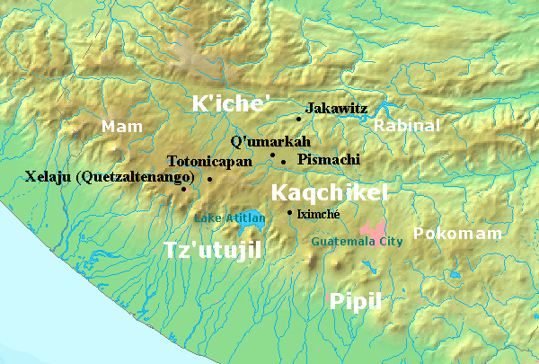
 Chitinamit is marked as Jakawitz on this map of the Postclassic Maya highlands
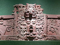
Maya civilization People · Languages · Society Religion · Mythology · Sacrifice Cities · Architecture · Calendar Stelae · Textiles · Trade Pre-Columbian Music · Writing History Preclassic Maya Classic Maya collapse Spanish conquest of Yucatán Spanish conquest of Guatemala Chitinamit (or Chitinamit-Chujuyup) is an archeological site of the Maya civilization in the highlands of Guatemala. It has been identified as Jakawitz, the first capital of the K'iche' Maya.[1] The site is located in the El Quiché department, in the municipality of Uspantán.[2] Chitinamit dates from the Early Classic through to the Late Postclassic periods and covers approximately 2 hectares (220,000 sq ft), making it the largest site in its region.[3]
Contents
Site description
The site overlooks the Queca River in a rugged region that is considered particularly poor for agriculture, it is therefore likely that the mountain-top location was selected because it was readily defensible.[4] The site is located on the mountain of Chujuyup, on the western edge of the Chuyujup Valley and was excavated in 1977 by Kenneth Brown of the University of Houston.[5] It is defended by a stone rampart and possesses stone terraces, together with a ballcourt and a temple to the K'iche' patron god, also named Jakawitz. Its occupation seems to have come to an violent end, with many projectile points being found together with evidence of the burning of buildings.[6]
Chitinamit includes residential structures measuring roughly 3 by 7 metres (9.8 by 23 ft) with the walls marked out with vertical schistose slabs measuring approximately 15 centimetres (5.9 in) high. These structures differ from the architectural style of the original Maya population and are presumed to represent the style of intrusive K'iche' lineages.[7] The site is arranged around an enclosed plaza.[8]
See also
Notes
- ^ Sharer & Traxler 2006, p.622.
- ^ Ministerio de Cultura y Deportes. Item 1005.
- ^ Sharer & Traxler 2006, p.290. Smith 2005, p.423. Van Akkeren 2002, p.1.
- ^ Christenson 2003, 2007, p.210.
- ^ Carmack & Weeks 1981, pp.324-326. Van Akkeren 2002, p.1. Christenson 2003, 2007, p.210.
- ^ Fox 1989, p.674.n.9.
- ^ Fox 1987, 2008, p.91.
- ^ Carmack 2001a, p.288.
References
-
- Carmack, Robert M.; and John M. Weeks (April 1981). "The Archaeology and Ethnohistory of Utatlan: A Conjunctive Approach". American Antiquity (Society for American Archaeology) 46 (2): 323–341. doi:10.2307/280211.
- Carmack, Robert M. (2001a). Kik'ulmatajem le K'iche'aab': Evolución del Reino K'iche'. Guatemala: Iximulew. ISBN 99922-56-22-2. OCLC 253481949. (Spanish)
- Christenson, Allen J. (2003, 2007). "Popul Vuh: Sacred Book of the Quiché Maya People" (PDF online publication). Mesoweb articles. Mesoweb: An Exploration of Mesoamerican Cultures. http://www.mesoweb.com/publications/Christenson/PopolVuh.pdf. Retrieved 2010/01/23.
- Fox, John W. (September 1989). "On the Rise and Fall of Tuláns and Maya Segmentary States". American Anthropologist, New Series (Oxford/Arlington, VA: Blackwell Publishing on behalf of the American Anthropological Association) 91 (3): 656–681. doi:10.1525/aa.1989.91.3.02a00080.
- Fox, John W. (1987, 2008). Maya Postclassic state formation. Cambridge, UK and New York, USA: Cambridge University Press. ISBN 978-0-521-10195-0. OCLC 297146853.
- Ministerio de Cultura y Deportes. "Base de Datos Sitios Arqueológicos" (PDF). Guatemala: Ministerio de Cultura y Deportes. http://www.mcd.gob.gt/wp-content/uploads/2009/03/sitios-arqueologicos-con-lugares-sagrados.pdf. Retrieved 2010-01-23. (Spanish)
- Sharer, Robert J.; with Loa p. Traxler (2006). The Ancient Maya (6th (fully revised) ed.). Stanford, CA: Stanford University Press. ISBN 0-8047-4817-9. OCLC 57577446.
- Smith, Michael E. (May 2005). "City Size in Late Postclassic Mesoamerica". Journal of Urban History (Sage Publications) 31 (4): 403–434. doi:10.1177/0096144204274396.
- van Akkeren, Ruud (2002). "El lugar en donde salió el primer sol para los K’ich’e; Jakawits, su nueva ubicación." (versión digital). XV Simposio de Investigaciones Arqueológicas en Guatemala, 2001 (edited by J.P. Laporte, H. Escobedo and B. Arroyo) (Guatemala: Museo Nacional de Arqueología y Etnología): 1–12. http://asociaciontikal.com/pdf/01-01%20-%20Akkeren%20-%20en%20PDF.pdf. Retrieved 2010-01-23. (Spanish)
Categories:- Maya sites
- Maya sites in Guatemala
- Archaeological sites in Guatemala
- Former populated places in Guatemala
- Quiché Department
- K'iche'

Wikimedia Foundation. 2010.