- Chotila
-
Chotila — town — Coordinates 22°25′30″N 71°11′17″E / 22.425°N 71.188°ECoordinates: 22°25′30″N 71°11′17″E / 22.425°N 71.188°E Country India State Gujarat District(s) Surendranagar Time zone IST (UTC+05:30) Codes-
• Vehicle • Gj-13
Chotila is a worship place of Hindu religion in Surendranagar district, located near Rajkot, Gujarat.
Contents
History
Historically, this area is called 'Panchal'.It is the worship place for Mata Chamunda, which is one of the 64 Avatars of Shakti,others being Bahuchar Mata, Kali Mata, Ambaji Mata etc. Chamunda Mataji is the Kuldevi (family Goddess) of many Hindus. Earlier Chotila was princely state of Khachar dynasty. It was having area of 18 km2. Chotila is also the birth-place of famous Gujarati poet Zaverchand Meghani.
Geography
 Chotila town
Chotila is also a small town, in the district Surendranagar.Chotila is a small town having population of around 20,000 people and is a Nagarpalika, Taluka head quarter and Legislative Assembly area. The Mataji temple is situated at the top of the Chotila hill. Mataji temples are always located at the top of the hills in India and the reason for this is that if you want darshnas Mataji, you will have to undergo some physical strain. Total footsteps are around 366. Chotila is located on the Rajkot-Ahmedabad national highway no.8A.It is around 170 km. from Ahmedabad and 60 km from Rajkot. Compare to sea level Chotila is the tallest point in Saurashtra region. The height of the hill is 1,173 feet.
Chamunda Mata Temple
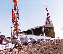 Temple of Chamunda Mata on Chotila hill
The story is when Demons Chand and Mund came to conquer Devi Mahakali and in the fight that ensues, the Devi cut their heads and presented these to Maa Ambika, who in turn told Mahakali that you will be worshipped as Chamunda Devi. You can start your climb from the base after walking some distance. There are stoned steps up to the top of the hill. These steps were not covered by the shade before. However, a good shade and railings now cover the entire walkway thus providing comfort to all the pilgrims. The temple is crowded with tourists and pilgrims all round the year specially during the Navratri Festival. The Chotila village is situated at the foot of the Chotila hill.As soon as you reach Chotila, you will find number of shops that sale prasads of Mataji, various types of Gujarati souvenirs like thick bangles with engraving, CDs and DVDs of Chamunda Mataji, and many toys for all ages of children. There are thousands of such shops located at the base of the Chotila hill. At the end of the navaratri festival, a big havan is taking place on top of the Chotila hill. It is said that after the aarti at chotila hill in the evening everybody comes down the hill and that no one stays there that's what Chamunda Mataji has said. Also people have encountered that there is a lion on the hill or dungar of chotila.
Nearby Places
Rajkot is only 60 km. away from Chotila. It is also the nearest airport from this place. Ahmedbad airport is the nearest international air-port.
 Chotila Hill
Hindu Temples in Gujarat Akshardham (Gandhinagar) • Ambaji • Becharaji Temple • Camp Hanuman Temple • Chotila • Dwarakadheesh Temple • Pimpleshwar Mahadev, Saldi • Santram Mandir • Shamlaji • Shri Hanuman Mandir, Salangpur • Shri Nathjidada Ni Jagya • Shri Swaminarayan Mandir, Ahmedabad • Shri Swaminarayan Mandir, Bhuj (New temple) • Shri Swaminarayan Mandir, Bhuj • Shri Swaminarayan Mandir, Dholera • Shri Swaminarayan Mandir, Gadhada • Shri Swaminarayan Mandir, Junagadh • Shri Swaminarayan Mandir, Vadtal • Somnath • Sun Temple, Modhera
Categories:- Shakti temples
- Hindu temples in Gujarat
- Cities and towns in Surendranagar district
-


Wikimedia Foundation. 2010.