- Bighorn National Forest
-
Bighorn National Forest IUCN Category VI (Managed Resource Protected Area)

Location Sheridan, Big Horn, Johnson, and Washakie counties, Wyoming, USA Nearest city Sheridan, WY Coordinates 44°32′0″N 107°21′0″W / 44.533333°N 107.35°WCoordinates: 44°32′0″N 107°21′0″W / 44.533333°N 107.35°W Area 1.1 million acres (4,500 km²) Established 1897 Governing body U.S. Forest Service Bighorn National Forest is located in northern Wyoming, United States and consists of over 1.1 million acres (4,500 km²). Created as a US Forest Reserve in 1897, it is one of the oldest government-protected forest lands in the U.S. The forest is well east of the continental divide and extends from the Montana border for a distance of 80 miles (130 km) along the spine of the Big Horn Mountains, an outlying mountain range separated from the rest of the Rocky Mountains by Bighorn Basin. Elevations range from 5,000 feet (1,500 m) along the sagebrush and grass-covered lowlands at the foot of the mountains, to 13,189 feet (4,020 m) on top of Cloud Peak, the highest point in the Big Horn Mountains. The forest is named after the Bighorn River, which is partially fed by streams found in the forest. While the river and forest used the name "Bighorn" all in one word, the mountains associated with the forest are referred to as the "Big Horns".
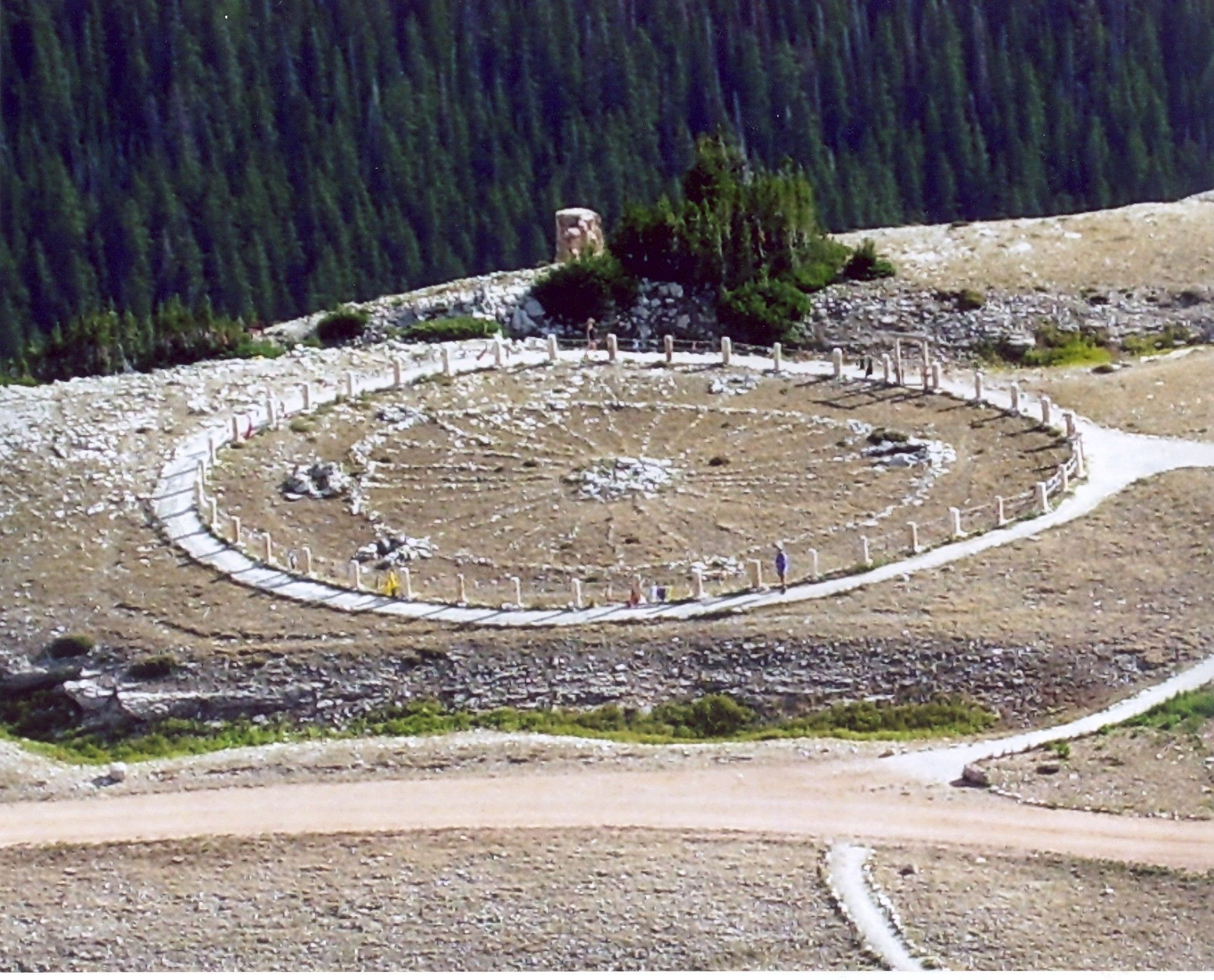
 The Medicine Wheel National Historic Landmark in the National Forest
Within the forest is the Cloud Peak Wilderness area in which no motorized or mechanical equipment is allowed. The only access into the 189,000 acre (765 km²) wilderness is on foot or horseback. There are 1,500 miles (2,400 km) of trails in the forest, along with 32 improved campgrounds, lodges, and three scenic vehicular byways. U.S. Highway 14, also known as the Bighorn Scenic Byway, crosses the middle of the 30-mile (48 km) wide forest. Medicine Wheel Passage (U.S. Highway 14A) crosses in the north passing the Medicine Wheel National Historic Landmark, while the Cloud Peak Skyway (U.S. 16) crosses the highest pass in the forest (Powder River Pass 9,677 ft/ 2,950 m) and is located in the southern section of the forest.
The forest is primarily lodgepole pine, along with several species of spruce, fir, and aspen. While grizzly bears have not inhabited the forest since the early 20th century, black bears are widespread. Other large mammals include elk, mule deer, pronghorn, and moose. Numerous lakes are found within the forest and most are naturally stocked with trout and at least 100 other fish species. Meadowlark Lake is a popular recreation area created by the construction of a dam built by Company 841 of the Civilian Conservation Corps in 1936. Water quality sampling from the lakes shows the highest acid rain deposition of any mountain chain in the Rockies.
The forest headquarters is located in Sheridan, Wyoming. There are local ranger district offices in Buffalo, Lovell, and Sheridan.[1]
References
Further reading
- Georgen, Cynde. In the shadow of the Bighorns: A history of early Sheridan and the Goose Creek valley of northern Wyoming. Sheridan, Wyoming: Sheridan County Historical Society, 2010. ISBN 978-0-9792871-7-6
External links
- "Bighorn National Forest". U.S. Forest Service. http://www.fs.fed.us/r2/bighorn/index.shtml. Retrieved 2006-07-08.
- "Map of Bighorn National Forest". U.S. Forest Service. Archived from the original on 2009-06-12. http://web.archive.org/web/20090612021214/http://www.fs.fed.us/r2/bighorn/maps/rec/. Retrieved 2011-08-08.
Federal Bridger • Cloud Peak • Encampment River • Fitzpatrick • Gros Ventre • Huston Park • Jedediah Smith • North Absaroka • Platte River • Popo Agie • Savage Run • Teton • Washakie • Winegar HoleState State Parks:Bear River • Boysen • Buffalo Bill • Curt Gowdy • Edness K. Wilkins • Glendo • Guernsey • Hawk Springs • Hot Springs • Keyhole • Seminoe • Sinks CanyonState Historical Sites:Ames Monument • Connor Battlefield • Fort Bridger • Fort Fetterman • Fort Fred Steele • Fort Phil Kearny • Granger Stage Station • Governors' Mansion • Independence Rock • Legend Rock • Names Hill • Oregon Trail Ruts • Piedmont Charcoal Kilns • Point of Rocks Stage Station • Register Cliff • South Pass City • Trail End • Pioneer Memorial Museum • Territorial Park • Medicine Lodge •County County Parks:Ayres Natural BridgeCategories:- IUCN Category VI
- National Forests of Wyoming
- Civilian Conservation Corps in Wyoming
- Protected areas of Sheridan County, Wyoming
- Protected areas of Big Horn County, Wyoming
- Protected areas of Johnson County, Wyoming
- Protected areas of Washakie County, Wyoming

Wikimedia Foundation. 2010.