Church of All Saints, Wrington

Church of All Saints, Wrington
Church of All Saints
Church of All Saints, Wrington is located in Somerset
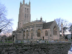
Location within Somerset
General information
Town or city Wrington
Country England
Coordinates 51°21′40″N 2°45′57″W / 51.3610°N 2.7658°W / 51.3610; -2.7658
Completed 13th century

The Church of All Saints in Wrington, Somerset, England has 13th-century foundations, and was remodelled with the addition of a west tower around 1450. It is a Grade I listed building.[1]

Wickham dates the church to the period from 1420 to 1450,[2] and Freeman described it as "one of the "highest achievements of architectural genius".[3] The tower was completed around 1449.[4]

The church was restored in 1859 with further restoration to the four-stage 113.5 feet (35 m)[5] tower in 1948.[1] The tower has set-back buttresses which develop into crocketted pinnacles at the top stage. The top displays moulded string courses and a trefoil pierced triangular parapet with gargoyles and corner pinnacles. The belfry stair is in the south-east turret.

The interior includes stone busts to John Locke and Hannah More dating from the early 19th century on either side of the door. The chancel has Gothic reredos by Charles Barry dating from 1832. The rood screen is from the 16th century.

See also

References

  1. ^ a b "Church of All Saints". Images of England. http://www.imagesofengland.org.uk/details/default.aspx?id=34023. Retrieved 2007-02-26. 
  2. ^ Wickham, Archdale Kenneth (1965). Churches of Somerset. London: David & Charles. 
  3. ^ Brereton, R. P (1904). "Somerset Church Towers". The Archaeological Journal (Somersetshire Archaeological Society at Gillingham) lxii. 60 collotypes prepared for a planned monograph are in the British Museum, Add. MSS. 37260-3, were published by the Society.. 
  4. ^ Poyntz Wright, Peter (1981). The Parish Church Towers of Somerset, Their construction, craftsmanship and chronology 1350 - 1550. Avebury Publishing Company. ISBN 0861275020. 
  5. ^ "Description of the church". All Saints Wrington. http://www.wringtonsomerset.org.uk/allsaints/description.html. Retrieved 2008-03-05. 

External links


Wikimedia Foundation. 2010.

Игры ⚽ Поможем написать курсовую

Look at other dictionaries:

  • Wrington — infobox UK place country = England latitude= 51.3617longitude= 2.7606official name= Wrington civil parish= population = unitary england= North Somerset lieutenancy england=Somerset region= South West Englandconstituency westminster= Woodspring to …   Wikipedia

  • List of Grade I listed buildings in Somerset — There are over 6000 Grade I listed buildings in England. This page is a list of these buildings in the county of Somerset.Bath North East Somerset* Abbey Church, Bath (Grade A) * Abbey Church Yard, Bath: No 14 * Grand Pump Room, Bath * Grand Pump …   Wikipedia

  • List of towers in Somerset — The Somerset Towers, built in the 14th to 16th centuries, have been describe as among England s finest contributions to medieval art.cite book |last= Jenkins|first=Simon|title= England s Thousand Best Churches|year= 2000|publisher= Penguin… …   Wikipedia

  • Bilbie family — The Bilbie family were bell founders and clockmakers based initially in Chew Stoke, Somerset and later at Cullompton, Devon in south west England from the late 1600s to the early 1800s.Their importance to the local economy and in local history is …   Wikipedia

  • Yatton — See also: Yatton, Herefordshire Coordinates: 51°23′08″N 2°49′32″W / 51.3855°N 2.8256°W / 51.3855; 2.8256 …   Wikipedia

  • Weston-super-Mare — Oldmixon redirects here. For the writer, see John Oldmixon. Coordinates: 51°20′46″N 2°58′37″W / 51.346°N 2.977°W / 51.34 …   Wikipedia

  • Weston-super-Mare — Ciudad del Reino Unido Una vista de Weston super Mare …   Wikipedia Español

  • Redhill, Somerset — infobox UK place country = England latitude= 51.366979 longitude= 2.725859 official name= Redhill civil parish= population = unitary england= North Somerset lieutenancy england=Somerset region= South West England constituency westminster=… …   Wikipedia

  • United Kingdom — a kingdom in NW Europe, consisting of Great Britain and Northern Ireland: formerly comprising Great Britain and Ireland 1801 1922. 58,610,182; 94,242 sq. mi. (244,100 sq. km). Cap.: London. Abbr.: U.K. Official name, United Kingdom of Great… …   Universalium

  • List of schools in the South West of England — The following is a partial list of currently operating schools in the South West region of England. You may also find of use to find a particular school. See also the List of the oldest schools in the United Kingdom.Listed by local education… …   Wikipedia

Share the article and excerpts

Direct link
Do a right-click on the link above
and select “Copy Link”