- Church of St Thomas à Becket, Capel
-
Church of St Thomas à Becket, Capel 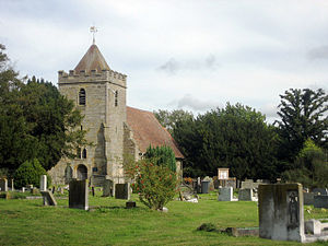
Church of St Thomas à Becket, Capel, from the southwestLocation in Kent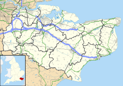
 Church of St Thomas à Becket, Capel
Coordinates: 51°10′35″N 0°20′28″E / 51.1764°N 0.3410°E OS grid reference TQ 637 445 Location Capel, Kent Country England Denomination Anglican Website Churches Conservation Trust History Dedication Thomas à Becket Architecture Functional status Redundant Heritage designation Grade I Designated 20 October 1954 Architectural type Church Style Norman, Gothic, Gothic Revival Specifications Materials Sandstone, partly rendered
Roof tiled Wall paintings
The Church of St Thomas à Becket, Capel, is a redundant Anglican church in the village of Capel, Kent, England. It has been designated by English Heritage as a Grade I listed building,[1] and is under the care of the Churches Conservation Trust.[2] Capel is located 4 miles (6 km) east of Tonbridge, off the B2017 road.[2] It is said that Thomas à Becket preached either in the church,[2] or under a yew tree in the churchyard.[3][4]
Contents
History
The church originated in the Norman era. The chancel arch dates from the 13th century, and the tower and the nave from the 14th or early 15th century. Alterations were made in the 16th century.[1] There was a fire in the tower in 1639, and it had to be partly rebuilt.[2] The chancel and the south wall were refurbished during the 19th century.[1] The church was vested in the Churches Conservation Trust on 8 July 1986.[5] It is open daily for visitors.[2]
Architecture
Exterior
The church is constructed in sandstone, and the chancel and north wall have been rendered. The roof is tiled. The plan of the church is simple, consisting of a nave, a chancel with a north vestry, and a relatively large but short tower, through which the church is entered. The tower is in a single stage, and stands on a moulded plinth. It has diagonal buttresses, a battlemented parapet, and a pyramidal roof surmounted by a 20th-century cast iron weathervane. The bell openings are lancets and are louvred, with slit openings beneath them. On the west face of the tower is a plain round-headed doorway, with a double-lancet window above it. In the south wall of the nave are four two- or three-light windows, and in the north wall are two lancet windows. In the south wall of the chancel is a priest's door. The east window dates from the 19th century and is in Early English style.[1]
Interior
Inside the tower is a porch and a timber staircase. The walls of the interior of the church are lime-washed, and the floors are tiled. On the north wall of the nave are wall paintings probably dating from the 13th century.[1] They depict biblical scenes, including Cain and Abel and Christ's entry into Jerusalem. They were discovered in 1967 and restored by Mrs Eve Baker.[2] Towards the west end of this wall is a niche. The chancel contains a 20th-century stone altar. The communion rails are dated 1662. The oak pulpit dates from the 19th century. The stone font is probably medieval, and consists of an octagonal bowl on a cylindrical shaft. Apart from brass plaques commemorating those who died in the World Wars, the only memorial in the church is a plain marble plaque dated 1834. Above the tower arch is a board painted with the royal arms. Also on the west wall are further boards inscribed with the Lord's Prayer and the Ten Commandments. The stained glass in the east window is dated 1905.[1]
External features
In the churchyard are two chest tombs and 15 headstones, each of which has been designated as a Grade II listed building. One chest tomb is anonymous and dates from the 16th or 17th century.[6] The inscription on the other tomb is illegible, but it is dated 1768.[7] The named single headstones are to Jane and Samuel Brook, dated 1781,[8] to Elizabeth Daniel, dating from the 17th century,[9] to Thomas Larkin and his wife, dated 1769,[10] to John Larkin, dated 1753,[11] to John Millesden, dated 1758,[12] to Elizabeth Relph, dated 1759,[13] to Ann Town dated 1732,[14] and to Ambrose Vineen and his wife, dated 1784.[15] There are pairs of headstones to the Hubble family, dating from the middle of the 18th century,[16] to the Kipping family dated from the 1680s,[17] and to the Mills family from the late 18th century.[18] There are also four illegible or anonymous single headstones.[19][20][21][22]
See also
- List of churches preserved by the Churches Conservation Trust in South East England
References
- ^ a b c d e f "Church of St Thomas à Becket, Capel", The National Heritage List for England (English Heritage), 2011, http://list.english-heritage.org.uk/resultsingle.aspx?uid=1262867, retrieved 18 April 2011
- ^ a b c d e f Church of St Thomas a Becket, Capel, Kent, Churches Conservation Trust, http://www.visitchurches.org.uk/Ourchurches/Completelistofchurches/Church-of-St-ThomasBecket-Capel-Kent/, retrieved 12 April 2011
- ^ St Thomas à Becket, Capel, Tudeley cum Capel with Five Oak Green parish, http://www.tudeley.org/stthomasbecketcapel.htm, retrieved 12 April 2011
- ^ Capel, St Thomas Church, Britain Express, http://www.britainexpress.com/attractions.htm?attraction=4041, retrieved 12 April 2011
- ^ (PDF) Diocese of Canterbury: All Schemes, Church Commissioners/Statistics, Church of England, 2011, pp. 1–2, http://www.churchofengland.org/media/810388/canterbury%20-%20all%20schemes.pdf, retrieved 12 April 2011
- ^ "Anonymous chest tomb approximately 1.5 metres south of the nave of the Church of St Thomas à Becket, Capel", The National Heritage List for England (English Heritage), 2011, http://list.english-heritage.org.uk/resultsingle.aspx?uid=1251245, retrieved 18 April 2011
- ^ "Illegible chest tomb approximately 9 metres east of the chancel of the Church of St Thomas à Becket, Capel", The National Heritage List for England (English Heritage), 2011, http://list.english-heritage.org.uk/resultsingle.aspx?uid=1262868, retrieved 18 April 2011
- ^ "Brook headstone approximately 9 metres southeast of the chancel of the Church of St Thomas à Becket, Capel", The National Heritage List for England (English Heritage), 2011, http://list.english-heritage.org.uk/resultsingle.aspx?uid=1251246, retrieved 18 April 2011
- ^ "Daniel headstone approximately 10 metres southeast of the chancel of the Church of St Thomas à Becket, Capel", The National Heritage List for England (English Heritage), 2011, http://list.english-heritage.org.uk/resultsingle.aspx?uid=1251247, retrieved 18 April 2011
- ^ "Larkin headstone approximately 9 metres south of the chancel of the Church of St Thomas à Becket, Capel", The National Heritage List for England (English Heritage), 2011, http://list.english-heritage.org.uk/resultsingle.aspx?uid=1262869, retrieved 18 April 2011
- ^ "Larkin headstone approximately 5.5 metres east of the chancel of the Church of St Thomas à Becket, Capel", The National Heritage List for England (English Heritage), 2011, http://list.english-heritage.org.uk/resultsingle.aspx?uid=1251248, retrieved 18 April 2011
- ^ "Millesden headstone approximately 1.5 metres east of the vestry of the Church of St Thomas à Becket, Capel", The National Heritage List for England (English Heritage), 2011, http://list.english-heritage.org.uk/resultsingle.aspx?uid=1251274, retrieved 18 April 2011
- ^ "Ralph headstone approximately 4.5 metres south of the chancel of the Church of St Thomas à Becket, Capel", The National Heritage List for England (English Heritage), 2011, http://list.english-heritage.org.uk/resultsingle.aspx?uid=1251250, retrieved 18 April 2011
- ^ "Town headstone approximately 5 metres south-southeast of the chancel of the Church of St Thomas à Becket, Capel", The National Heritage List for England (English Heritage), 2011, http://list.english-heritage.org.uk/resultsingle.aspx?uid=1251276, retrieved 18 April 2011
- ^ "Vineen headstone approximately 7 metres southeast of the chancel of the Church of St Thomas à Becket, Capel", The National Heritage List for England (English Heritage), 2011, http://list.english-heritage.org.uk/resultsingle.aspx?uid=1251251, retrieved 18 April 2011
- ^ "Pair of Hubble headstone approximately 3.5 metres east of the chancel of the Church of St Thomas à Becket, Capel", The National Heritage List for England (English Heritage), 2011, http://list.english-heritage.org.uk/resultsingle.aspx?uid=1262841, retrieved 18 April 2011
- ^ "Pair of Kipping headstones approximately 2.5 metres east of the vestry of the Church of St Thomas à Becket, Capel", The National Heritage List for England (English Heritage), 2011, http://list.english-heritage.org.uk/resultsingle.aspx?uid=1262870, retrieved 18 April 2011
- ^ "Pair of Mills headstones approximately 9 metres south of the nave of the Church of St Thomas à Becket, Capel", The National Heritage List for England (English Heritage), 2011, http://list.english-heritage.org.uk/resultsingle.aspx?uid=1251249, retrieved 18 April 2011
- ^ "Illegible headstone approximately 9 metres south of the nave of the Church of St Thomas à Becket, Capel", The National Heritage List for England (English Heritage), 2011, http://list.english-heritage.org.uk/resultsingle.aspx?uid=1262843, retrieved 18 April 2011
- ^ "Anonymous headstone approximately 15 metres west-northwest of the tower of the Church of St Thomas à Becket, Capel", The National Heritage List for England (English Heritage), 2011, http://list.english-heritage.org.uk/resultsingle.aspx?uid=1251252, retrieved 18 April 2011
- ^ "Illegible headstone approximately 6 metres southeast of the chancel of the Church of St Thomas à Becket, Capel", The National Heritage List for England (English Heritage), 2011, http://list.english-heritage.org.uk/resultsingle.aspx?uid=1251253, retrieved 18 April 2011
- ^ "Illegible headstone approximately 5 metres southeast of the chancel of the Church of St Thomas à Becket, Capel", The National Heritage List for England (English Heritage), 2011, http://list.english-heritage.org.uk/resultsingle.aspx?uid=1262855, retrieved 18 April 2011
External links
 Media related to St Thomas a Becket, Capel at Wikimedia CommonsCategories:
- Grade I listed buildings in Kent
- Grade I listed churches
- Church of England churches in Kent
- Norman architecture
- English Gothic architecture
- Gothic Revival architecture in England
- Churches preserved by the Churches Conservation Trust


Wikimedia Foundation. 2010.