- Berat Castle
-
Berat Castle Kalaja e Beratit Berat, Albania 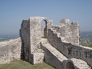
Berat CastleType Castle Built by Illyrians Open to
the publicYes Battles/wars Battles under Skanderbeg 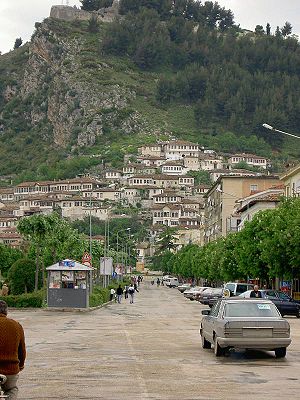
Citadel of Berat (pictured at the top of the hill)Berat Castle (Albanian: Kalaja e Beratit) is a fortress overlooking the town of Berat, Albania. It dates mainly from the 13th century and contains many Byzantine churches in the area and Ottoman mosques.[1] It is built on a rocky hill on the left bank of the river Osum and is accessible only from the south.
Contents
History
After being burned down by the Romans in 200 B.C. the walls were strengthened in the fifth century under Byzantine Emperor Theodosius II, and were rebuilt during the 6th century under the Emperor Justinian I and again in the 13th century under the Despot of Epirus, Michael Angelus Comnenus, cousin of the Byzantine Emperor. The main entrance, on the north side, is defended by a fortified courtyard and there are three smaller entrances.
The fortress of Berat in its present state, even though considerably damaged, remains a magnificent sight. The surface that it encompasses made it possible to house a considerable portion of the cities inhabitants. The buildings inside the fortress were built during the 13th century and because of their characteristic architecture are preserved as cultural monuments. The population of the fortress was Christian, and it had about 20 churches (most built during the 13th century) and only one mosque, for the use of the Turkish garrison, (of which there survives only a few ruins and the base of the minaret). The churches of the fortress were damaged through years and only some have remained.
Berat Castle is depicted on the reverse of the Albanian 10 lekë coin, issued in 1996 and 2000.[2]
Gallery
-

Berat Fortress.
See also
References
- ^ UNESCO
- ^ Bank of Albania. Currency: Albanian coins in circulation, issue of 1995, 1996 and 2000. – Retrieved on 23 March 2009.
- This article incorporates information from the equivalent article on the Albanian Wikipedia.
Castles in Albania Ali Pasha Castle • Badhrë Castle • Bashtovë Castle • Berat Castle • Borshi Castle • Burgajet Castle • Dajti Castle • Drisht Castle • Elbasan Castle • Fortress of Justinian • Gjirokastër Castle • Kaninë Castle • Krujë Castle • Lezhë Castle • Libohovë Castle • Lëkurësi Castle • Margëlliç Castle • Peqin Castle • Petrelë Castle • Pogradec Castle • Porto Palermo Castle • Prezë Castle • Rodoni Castle • Rozafa Castle • Skelë Castle • Tujani Castle • Vokopolë Castle • Castle of Gjon BoçariCategories:- Albanian building and structure stubs
- European castle stubs
- Castles in Albania
- Kutmichevitsa
- Illyrian architecture
-


Wikimedia Foundation. 2010.