- Manchester city centre
-
Coordinates: 53°28′45″N 2°14′39″W / 53.479167°N 2.244167°W
Manchester city Centre 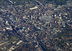
Aerial view of Manchester city centre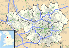
 Manchester city Centre
Manchester city Centre shown within Greater ManchesterArea 2.2 sq mi (5.7 km2) Population 11,689 (2001 Census) - Density 5,460 /sq mi (2,110 /km2) OS grid reference SJ839980 - London 163 mi (262 km) SE Metropolitan borough Manchester Metropolitan county Greater Manchester Region North West Country England Sovereign state United Kingdom Post town MANCHESTER Postcode district M1 - M4 & M15 Dialling code 0161 Police Greater Manchester Fire Greater Manchester Ambulance North West EU Parliament North West England UK Parliament Manchester Central List of places: UK • England • Greater Manchester Manchester city centre is the central business district of Manchester, England. It lies within the Manchester Inner Ring Road, next to the River Irwell.[1] The electoral ward of Manchester Central has an area of 2.2 square miles (5.7 km2) and a population of 11,689.[2]
The city centre evolved from the civilian vicus of the Roman fort of Mamucium, on a sandstone bluff near the confluence of the rivers Medlock and Irwell.[3] In the Middle Ages, what is now the city centre was the township of Manchester.
Extensively redeveloped since the Manchester Blitz of 1941 and 1996 IRA bomb, the city centre remains the commercial and cultural centre of Manchester. The majority of the tallest buildings and structures in Manchester are located in the city centre, including Manchester Town Hall in Albert Square and the Beetham Tower, the tallest building in the United Kingdom outside London.
Contents
History
Main article: History of Manchester One of the boundary signs of the former township of Manchester on the banks of the Medlock
Manchester evolved from the civilian vicus associated with the Roman fort of Mamucium, which was established c. AD 79 on a sandstone bluff near the confluence of the rivers Medlock and Irwell, in a position defensible from the Brigantes.[4] Once the Romans had abandoned Britain, the focus of settlement in Manchester shifted to the confluence of the rivers Irwell and Irk.[5] During the Dark Ages which followed – and persisted until the Norman Conquest – the settlement at Manchester was in the territory of several different petty kingdoms.[6] In the Middle Ages, what is now the city centre was the township of Manchester.
Manchester Castle – a medieval fortification, probably taking the form of a ringwork – was located on a bluff where the rivers Irk and Irwell meet.[7] The castle was first mentioned in 1184 and was recorded in 1215 as belonging to the barons of Manchester, the Grelley family.[8] It has been described as "of no political or military importance".[9] The Grelleys replaced the castle with a fortified manor house, which in turn was replaced by a college of priests (founded in 1421).[10] In 1547 the college was dissolved and the property acquired by the Earl of Derby and early in the reign of King Charles II it was sold to the Governors who had been appointed in the will of Humphrey Chetham. By royal charter in 1665 Chetham's Hospital was established and eventually this became Chetham's School of Music.[11]
Particular areas
 Piccadilly Gardens, a green space in the city (view towards Market Street)
- Western section
- The Northern Quarter is in the northwest (east of Victoria Station and northwest of Piccadilly Gardens).
- The Millennium Quarter is the area around Manchester Cathedral, which has been extensively redeveloped after the IRA bomb of 1996, containing Shambles Square, Exchange Square, and Cathedral Gardens.
- Spinningfields is an area in the west adjoining the middle part of Deansgate which has undergone much large-scale redevelopment.
- Castlefield is an area in the extreme southwest between Deansgate and the River Irwell with the sites of the Roman fort and Liverpool Road Railway Station.
- Eastern section
- Piccadilly: the largest public square in the centre and the most important transport interchange. The area known as Piccadilly runs eastwards from the end of Market Street to a point where London Road begins: to the south of this are the gardens and paved areas.
- Chinatown is an area to the south of Piccadilly Gardens with many oriental restaurants and other facilities of a far eastern character.
- The Gay Village is a part of the centre east of Portland Street and west of Whitworth Street through which runs the Rochdale Canal; it contains many bars, clubs and other facilities for the gay community.
Demography
Further information: Demography of Greater ManchesterCentral compared 2001 UK census Central[12] City of Manchester[13] England Total population 11,689 392,819 49,138,831 White 82.0% 81.0% 91.0% Asian 4.3% 9.1% 4.6% Black 2.8% 4.5% 2.3% Chinese or other 8.0% 2.7% 0.9% Mixed 2.8% 3.2% 1.3% As of the 2001 UK census, the political ward of "Central", which covers an area of 2.14 square miles (5.54 km2), had a population of 11,689 with a population density of 5,460 inhabitants per square mile (2,108 /km2). While this was lower than the population density for the whole city (8,798 inhabitants per square mile (3,397 /km2)), the proportion of land dedicated to domestic buildings was lower in the ward than in the whole city (6.7% compared to 8.0%).[14] There was a female-to-male ratio of 100 to 113, much higher than the 100 to 95 ratio for all England.[15] Of those over 16 years old, 65.7% were single (never married), 13.7% married, and 8.7% divorced; this was significantly different from the national figures of 30.2% single, 43.5% married, and 8.2% divorced.[16] The ward's 6,188 households included 61.1% one-person, 8.6% married couples living together, 9.0% were co-habiting couples, and 12.4% single parents with their children; compared to national figures, there was a high proportion of single person households, and a low proportion of married couples living together.[17] Of those aged 16–74, 30.5% had no academic qualifications, lower than the figure for the City of Manchester (34.0%) but slightly above that of the whole of England (28.9%).[15] The ward had a significantly higher percentage of adults with a diploma or degree than the city or England as a whole. Of the ward's residents aged 16–74, 26.3% had an educational qualification such as first degree, higher degree, qualified teacher status, qualified medical doctor, qualified dentist, qualified nurse, midwife, or health visitor, compared to 21.4% in Manchester and 19.9% nationwide.[15]
Economy
 Manchester City Centre Skyline Christmas Eve 2010
Deansgate and Market Street are the centre's principal retail streets and King Street (with high-class shops) and St Ann's Square are known for their specialist fashion and other shops. There is also a large indoor shopping mall called the Manchester Arndale Centre. Manchester city centre has several large department stores including Marks and Spencer and Debenhams on Market Street, House of Fraser on Deansgate, Harvey Nichols on New Cathedral Street and Selfridges in Exchange Square. There are many leisure facilities in the city centre including the Printworks, a large facility containing a cinema (including an IMAX screen), numerous bars, clubs and restaurants and also Manchester's first Hard Rock Cafe. The Northern Quarter, centred around Oldham Street, is known for its Bohemian atmosphere and independent shops and cafes. The landscaping of the city centre has provided several public spaces including the newly developed Piccadilly Gardens, which incorporates fountains, green spaces, a concrete wall, and a Metrolink station (it has not been improved by the construction of an office block to the east). Exchange Square is located near Urbis, formerly an exhibition centre focusing on city life but now closed and due to re-open in mid-2011 as the National Football Museum. Both Piccadilly and Exchange Square are used for screening public events. Two of the city centre's oldest buildings, The Old Wellington Inn and Sinclair's Oyster Bar, were dismantled, moved 300 yards and re-erected in 1999 to create the new Shambles Square adjacent to Manchester Cathedral.[18]

There are other museums in Manchester city centre including the Manchester Museum of Science and Industry in Castlefield which includes many hands-on exhibits and the People's History Museum.
There are a great variety of restaurants in the city centre including a number owned by Paul Heathcote the chef. There is also a good stock of hotels in the city centre which include the Midland, Jarvis Piccadilly and Ramada Renaissance.
Nightlife
Manchester city centre has many nightclubs, many of which follow in the footsteps of the Haçienda nightclub which has now closed; the site has been redeveloped as a housing complex. There is a gay village around the Canal Street area in the east of the city centre, which plays host to an annual Gay Pride Festival, and a large Chinatown with numerous far eastern style restaurants. The area to the west which is bisected by Deansgate and crossed by Peter Street is also well-provided with bars and some clubs (e.g. The Moon under Water and Ampersand).
The city centre also has many bars, mostly located in the Northern Quarter, regarded by some as the central district's creative hub. The quarter is well-provided with bars of various sizes; these include 'TV 21', 'Bar Fringe', the cocktail bar 'Apotheca' and 'Trof'. Live music venues may also be found here, including the well-known 'Night & Day Cafe', newcomer 'MOHO Live' and jazz bar 'Matt & Phred's'.
Future developments
- St Peters Square - St Peter's Square, home of Manchester Central Library, is set to undergo massive multi-million pound redevelopment which will include pedestrianising the square, redeveloping Elizabeth House (the current empty building opposite the Central Library), creation of a contemporary memorial to the 1819 Peterloo Massacre and refurbishing the Library.[19] A competition has been held to decide upon the new design of the square.[20] It has recently been suggested that the Cenotaph should be moved to make room for a further tram line.[21]
- NOMA 53 - The Co-op has embarked on one of its most challenging projects to date, as it aims to transform a 20-acre (81,000 m2) section of Manchester into a new retail, office and residential quarter, where its own new headquarters will be housed. The site will be branded "NOMA 53" in reference to "NOrth MAnchester" and the locations co-ordinates. The £800 development includes the following developments:
1. The City Building will become the luxurious Hotel Indigo, which will include a Marco Pierre White restaurant and is set to open in autumn 2012.
2. Two buildings on the corner of Corporation Street and Balloon Street to be converted into 106,000 sq ft (9,800 m2) of grade A office accommodation. Completion by second half of 2013.
3. The Co-op's existing space in New Century House to be refurbished and brought to market when all staff have moved out, starting September 2012.
4. CIS Tower still to be occupied by the banking division, though parts may eventually be brought to market. The Co-op has the capacity to fund the revamp itself if necessary.
5. The Co-op's new HQ will house 4,000 of its staff and will be complete in September 2012.
6. Major new car park planned. Access to be gained from the inner ring-road, which is set to be re-routed.
7. Plot next to Angel Meadows has been identified as one of main areas for residential development.
8. Land opposite the CIS Tower, on the site of the former Arkwright's Mill earmarked for mixed-use development, comprising retail, residential and office space. Talks are underway with potential developers.
9. Space north of the CIS Tower is likely to be turned into office space, with a call centre one of the options being considered.[22]
- Spinningfields - The major new Business District west of Deansgate is still undergoing large scale development, with numerous new buildings such as 2 & 3 Hardman Boulevard, 1 The Avenue, and 2 Hardman Square either under design or under construction.[23]
See also
- List of tallest buildings in Manchester
- Manchester Central (UK Parliament constituency)
- Manchester
References
- Notes
- ^ http://www.manchester.gov.uk/downloads/CityCentreZoningMap.gif
- ^ Central (Key Figures), neighbourhood.statistics.gov.uk. URL accessed March 20, 2007.
- ^ Gregory (2007), pp. 1, 3.
- ^ Gregory (2007), pp. 1, 3.
- ^ Hylton (2003), pp. 3, 8.
- ^ Hylton (2003), p. 7.
- ^ Newman (2006), p. 141.
- ^ Nevell (2008), p. 41.
- ^ Kidd (1996), p. 13.
- ^ Nevell (2008), p. 42.
- ^ McKechnie (1915), pp. 54–55.
- ^ "Central (ward): Ethnic group". Office for National Statistics. http://neighbourhood.statistics.gov.uk/dissemination/LeadKeyFigures.do?a=7&b=5941650&c=M1+1AD&d=14&e=15&g=351218&i=1001x1003x1004&m=0&r=0&s=1241325606960&enc=1. Retrieved 3 May 2009.
- ^ "Manchester (local authority): Ethnic group". Office for National Statistics. http://neighbourhood.statistics.gov.uk/dissemination/LeadTableView.do?a=7&b=276778&c=Manchester&d=13&e=15&g=351271&i=1001x1003x1004&o=1&m=0&r=1&s=1241326334581&enc=1&dsFamilyId=47. Retrieved 3 May 2009.
- ^ "Central (ward): Key figures for physical environment". Office for National Statistics. http://neighbourhood.statistics.gov.uk/dissemination/LeadKeyFigures.do?a=7&b=5941650&c=M1+1AD&d=14&e=8&g=351218&i=1001x1003x1004&o=1&m=0&r=0&s=1241327115904&enc=1. Retrieved 3 May 2009.
- ^ a b c "Central (ward): Key statistics". Office for National Statistics. http://neighbourhood.statistics.gov.uk/dissemination/LeadKeyFigures.do?a=7&b=5941650&c=M1+1AD&d=14&e=15&g=351218&i=1001x1003x1004&m=0&r=0&s=1241325606960&enc=1. Retrieved 3 May 2009.
- ^ "Central (ward): Marital status". Office for National Statistics. http://neighbourhood.statistics.gov.uk/dissemination/LeadTableView.do?a=7&b=5941650&c=M1+1AD&d=14&e=15&g=351218&i=1001x1003x1004&m=0&r=0&s=1241327760415&enc=1&dsFamilyId=9. Retrieved 3 May 2009.
- ^ "Central (ward): Household composition". Office for National Statistics. http://neighbourhood.statistics.gov.uk/dissemination/LeadTableView.do?a=7&b=5941650&c=M1+1AD&d=14&e=15&g=351218&i=1001x1003x1004&m=0&r=0&s=1241327760400&enc=1&dsFamilyId=55. Retrieved 3 May 2009.
- ^ Greater Manchester County Records Office: Wellington Inn
- ^ http://menmedia.co.uk/news/business/s/1034096_plans_for_st_peters_square
- ^ http://www.manchester.gov.uk/info/200024/consultations/4749/st_peters_square_international_design_competition/1
- ^ Manchester's Cenotaph to be moved to make way for Metrolink tram line
- ^ http://menmedia.co.uk/manchestereveningnews/news/business/s/1426089_exciting-times-for-the-co-op---it-even-flourishes-in-hard-times
- ^ http://www.spinningfieldsonline.com/spinningfields2/masterplan
- Bibliography
- Gregory, Richard (ed) (2007). Roman Manchester: The University of Manchester's Excavations within the Vicus 2001–5. Oxford: Oxbow Books. ISBN 978-1-84217-271-1.
- Hylton, Stuart (2003). A History of Manchester. Chichester: Phillimore and co. Ltd.. ISBN 1-86077-240-4.
- Kidd, Alan ([1996] 1993). Manchester. Keele: Keele University Press. ISBN 1-85331-028-X.
- McKechnie, H. M., ed. (1915). Manchester in Nineteen Hundred and Fifteen. Manchester: University of Manchester Press.
- Nevell, Mike (2008). Manchester: The Hidden History. The History Press. ISBN 978-0-7524-4704-9.
- Newman, Caron (2006). "Medieval Period Resource Assessment". Archaeology North West 8: 115–144. ISSN 0962-4201.
Further reading
External links
- "Manchester City Centre Management". http://www.manchestercitycentremanagement.co.uk/.
- "Manchester city centre webcams". http://www.bbc.co.uk/manchester/webcams/.
The City of Manchester About Manchester Architecture · (Tallest buildings · Grade I buildings) · Cuisine · Culture · Economy · History · Media · (Television programmes) · Music · (Pop music) · People · Politics · Science · Sociology · Sport · Streets · Symbols · TransportDistricts Ancoats · Ardwick · Ardwick Green · Baguley · Belle Vue · Benchill · Beswick · Blackley · Bradford · Burnage · Castlefield · Cheetham Hill · Chinatown · Chorlton-cum-Hardy · Chorlton-on-Medlock · Chorltonville · City Centre · Clayton · Collyhurst · Crumpsall · Didsbury · Fallowfield · Gay Village · Gorton · Harpurhey · Hulme · Levenshulme · Longsight · Lower Crumpsall · Miles Platting · Moss Side · Moston · Newall Green · New Islington · New Moston · Newton Heath · Northenden · Northern Moor · Northern Quarter · Openshaw · Peel Hall · Piccadilly Village · Ringway · Rusholme · Sharston · Spinningfields · Whalley Range · Withington · Woodhouse Park · WythenshaweCategories:- Districts of Manchester
- Manchester City Council Wards
- Central business districts in the United Kingdom


Wikimedia Foundation. 2010.