- Bramalea Terminal
-
Bramalea Terminal

Station statistics Address 160 Central Park Drive[1] Coordinates 43°43′09″N 79°43′15″W / 43.71917°N 79.72083°WCoordinates: 43°43′09″N 79°43′15″W / 43.71917°N 79.72083°W Lines Züm QueenPlatforms 18 Other information Opened 1991 Rebuilt 2010 Accessible 
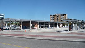
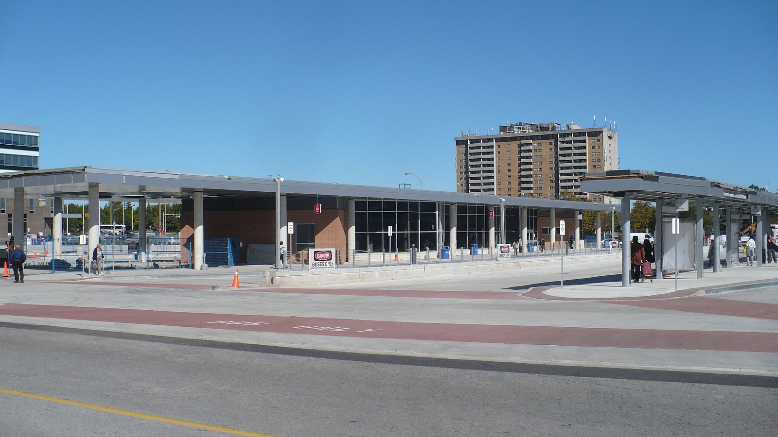
Code GO Transit: BLEA Owned by City of Brampton Presto status unknown Brampton Transit - Bramalea Terminal[2] is a bus station serving the community of Bramalea in Brampton, Ontario, Canada. It is located at the south west corner of Peel Centre Drive and Central Park Drive on the north side of the Brampton Civic Centre. The customer service centre building is situated in the northerly of two island platform areas, which are accessed by pedestrian cross walks. Within the building are service counters, washrooms, snack vending machines and a heated waiting area with screens displaying current bus route information.
Contents
History
Bus stops adjacent to Bramalea City Centre, referred to as City Centre Terminal,[3] were replaced with a terminal opened September 25, 1991. This replaced a previous terminal, closer to the parking structure; when it rained, "water pours down from the car park above."[3] That site, in use for almost two decades, was located on Clark Boulevard, on the south side of the mall. Mississauga's central transit hub was similarly named, as Mississauga City Centre Transit Terminal.
The City of Brampton issued a Request for Proposals due November 13, 2009, RFP 2009-078, "Construction of The New Bramalea City Centre Transit Terminal and Related Passenger Amenities Transit Priority Measures Road and Intersection Improvements". The estimated project value was $5,000,001 - $10,000,000, with a project team selected by Moffett & Duncan Architects Inc.[2] M. J. Dixon Construction Limited was awarded the contract, for $7,542,150.00 including taxes, the lowest price by a qualified contractor, out of the eight bids received.[4] Considered names for the station were "Brampton Transit - Bramalea Terminal", "Bramalea City Centre Transit Terminal", a variant of the existing branding, and "Brampton Transit - Queen East Terminal". The latter was noted to prevent Brampton Transit from using the name for possible future terminals further east on Queen Street. The first option, which was submitted to council for approval, was intended to "develop a new system wide guideline and protocol for the naming of its future terminals"[2]
The terminal was relocated, as of 20 September 2010[1], now east of the mall. The spot was formerly a city owned parking lot for the Brampton Civic Centre, the location of the Chinguacousy branch of the Brampton Library. The new terminal opened in conjunction with the commencement of Züm bus rapid transit service along Queen Street.
The issue of pedestrian safety was highlighted soon after the terminal opened. While a crosswalk was just a short distance south of the station, many would cross Peel Centre Drive (running east-west) or Team Canada Drive (north-south) at random places along the edge of the station lot. In May 2011, city council approved the creation of a scramble intersection crossing, which would stop both directions of traffic while pedestrians can cross one road, or cross both by heading diagonally. Resident George Startup lobbied the city on the issue, which Brampton Safe City supported.[5] Electrical issues delayed the installation of traffic lights at the intersection of Peel Centre Drive and Team Canada Drive, further adding to the issue.[6]
With cement was cracking around the catch basins, and the southeast driveway apron cracked; as part of "standard contract procedure", the contractor was brought in to fix the deficiencies. Repairs on the facility began October 3, in the first of three phases, to end October 21, 2011. During part of the repair, stops were moved to Team Canada Drive and Peel Centre Drive.[7]
Bus routes
- Brampton Transit bus routes[8]
- 501/501A Züm Queen
- 1/1A Queen
- 8 Centre
- 10 South Industrial
- 12 Grenoble
- 13 Avondale
- 15/15A Bramalea
- 16 Southgate
- 17 Howden
- 18/18A Dixie
- 19 Fernforest
- 20 East Industrial
- 40 Central Industrial
- 101 Airport Express
- 205 St. Thomas Aquinas S.S.
- 207/208 Mayfield S.S.
- 66 Canada's Wonderland Express (seasonal)
- GO Transit bus routes
- 32 Brampton Trinity Common GO Bus[9]
- 34 Brampton Local GO Bus via Dixon Road to Yorkdale/York Mills[10]
- 35 Brampton Local GO Bus via Highway 27 to Yorkdale/York Mills[10]
- 36 Express GO Bus to Yorkdale/York Mills[10]
Routes as of 1989[3]
- 1A Queen, Airport Road to Northwood Park
- 1B Queen, City Centre to Sheridan College
- 8 Centre, City Centre to Shoppers World
- 10 Industrial, City Centre to Four Corners
- 12 Grenoble, Bovaird Drive to City Centre
- 13 Avondale, City Centre to Avondale Boulevard/City Centre to Bramalea GO Station
- 14 Torbram, City Centre to Westwood Mall
- 15 Bramalea, Bovaird Drive to Advance Boulevard
- 16 Southgate, City Centre to Dearbourne Boulevard/City Centre to Bramalea GO Station
- 17 Howden, Bovaird Drive to City Centre
- 18 Dixie, Bovaird Drive to Cardiff Boulevard
- 20 East Industrial, City Centre to Walker Drive
- A Central Park, Bramalea GO Station to Central Park Drive
Nearby landmarks
- 10 Peel Centre Drive, Region of Peel buildings including council chambers and offices, executive offices, and many other departments
- Bramalea City Centre, shopping mall, including a FreshCo grocery store nearby
- Brampton Civic Centre, municipal facility, including the Chinguacousy Branch of Brampton Library, Pearson Theatre, Peel Health services,[11] etc. Formerly, it was the Township of Chinguacousy offices and City of Brampton offices.[2]
- Chinguacousy Park
- Knightsbridge Senior Centre
References
- ^ a b Brampton Transit: We're moving!
- ^ a b c d Dennis Cutajar on behalf of the Naming Committee, "Naming Report: "Brampton Transit - Bramalea Terminal"", May 12, 2010.
- ^ a b c http://www.angelfire.com/ca/TORONTO/history/Brampton.html
- ^ Klaus Stolch, P. Eng. and Jane Fera, CPPO, "Report to Council: Construction of the new Bramalea City Centre transit terminal and related passenger amenities, transit priority measures, road and intersection improvements, City of Brampton", City of Brampton, November 30, 2009.
- ^ Douglas, Pam (22 May 2011). "Terminal safety to improve". The Brampton Guardian (Brampton ON). http://www.bramptonguardian.com/news/article/1013162--terminal-safety-to-improve. Retrieved 28 June 2011.
- ^ Douglas, Pam (1 May 2011). "Safety a concern at terminal". The Brampton Guardian (Brampton ON). http://www.bramptonguardian.com/news/cityhall/article/1000929--safety-a-concern-at-terminal. Retrieved 28 June 2011.
- ^ Douglas, Pam (15 October 2011). "Transit terminal closed for repairs". The Brampton Guardian (Brampton ON). http://www.bramptonguardian.com/news/news/article/1226419. Retrieved 15 October 2011.
- ^ City of Brampton: Bramalea Terminal
- ^ GO Transit Table 32
- ^ a b c GO Transit Table 34
- ^ "Region health services come together". The Brampton Guardian (Brampton ON). 28 June 2011. http://www.bramptonguardian.com/community/health/article/1034942--region-health-services-come-together. Retrieved 28 June 2011.
External links
Categories:- Brampton Transit
- Bus stations in Ontario
Wikimedia Foundation. 2010.