- City of Rocks National Reserve
-
There is also City of Rocks State Park in New Mexico.
City of Rocks National Reserve IUCN Category V (Protected Landscape/Seascape)

Location Cassia County, Idaho, USA Nearest city Oakley, Idaho Coordinates 42°04′34″N 113°42′06″W / 42.0760257°N 113.7016761°WCoordinates: 42°04′34″N 113°42′06″W / 42.0760257°N 113.7016761°W Area 14,407 acres (5,830 ha)[1] Established November 18, 1988 Visitors 92,484 (in 2010)[2] Governing body National Park Service & Idaho Department of Parks and Recreation The City of Rocks National Reserve, also known as the Silent City of Rocks, is a United States National Reserve and state park lying 2 miles (3.2 km) north of the south central Idaho border with Utah. It is widely known for its excellent rock climbing and rock formations.
The rock spires in the City of Rocks and adjacent Castle Rocks State Park are largely composed of granitic rock of the Oligocene Almo pluton and Archean Green Creek Complex.
The City of Rocks is a popular rock climbing area, with numerous traditional and bolt-protected routes. In the 1980s, it was home to some of the most difficult routes in the USA, mostly developed by Idaho climber Tony Yaniro.[citation needed] Climbers in the region refer to the area as simply 'The City'.
California Trail wagon trains of the 1840s and 1850s left the Raft River valley and traveled through the area and over Granite Pass into Nevada. Names or initials of emigrants written in axle grease are still visible on Register Rock. Ruts from wagon wheels also can be seen in some of the rocks.
 North Fork Trailhead.
Contents
History
In 1849, an emigrant party with James Wilkins "encamped at the city of the rocks" on the California Trail just north of the Great Salt Lake Desert. Signatures in axle grease on rock faces can be seen today. One emigrant[who?] saw the distant rocks in August like "water thrown up into the air from numerous artificial hydrants." Beginning in 1843, City of Rocks was a landmark for emigrants on the California Trail and Salt Lake Alternate Trail[3] and later on freight routes and the Kelton, Utah to Boise, Idaho stage route.
The area's historical and geological values, scenery, and opportunities for recreation led to its designation as City of Rocks National Reserve in 1988. This unit of the National Park System is managed cooperatively by the National Park Service and the Idaho Department of Parks and Recreation.
Native American history
The Shoshone and Bannock tribes hunted the buffalo that once roamed in the City of Rocks area and gathered the nuts of the pinyon pine trees. The arrival of horses in the Americas in the 16th century and swelling European immigration disrupted the Shoshone-Bannock homelands and traditional way of life. They grew to resent the intruders but could do little to stop them. Most emigrants on the California Trail saw no Native Americans, but some of their journals record smoke rising from high hills and the surrounding mountains.
In 1826, Peter Skene Ogden and his Snake River brigade of beaver trappers were the first Euro-Americans to note the City of Rocks. Having few beaver, the area was ignored until 1843, when growing streams of wagons began flowing through the area in the summer.
California Trail
 City of Rocks National Reserve.
Early emigrant groups were guided by experienced mountain men such as Joseph B. Chiles and Joseph R. Walker. Later wagon parties followed the trails themselves, perhaps with the help of diary accounts of previous emigrants. The City of Rocks marked progress west for the emigrants and, for their loaded wagons, a mountain passage over nearby Granite Pass.[4] By 1846, emigrants headed for Oregon's Willamette Valley also used this route as part of the Applegate Trail. In 1848 Samuel J. Hensley[3]:b[5] pioneered the Salt Lake Alternate Trail from Salt Lake City via Emigrant Canyon[6] to Granite Pass. In 1852, some 52,000 people passed through the City of Rocks on their way to the California goldfields.
When the trails opened in the 1840s, Granite Pass was in Mexico and less than a mile from Oregon Territory. After 1850 the Pass became part of Utah Territory,[7] and in 1872 an Idaho-Utah boundary survey error[8] placed Granite Pass in Idaho Territory. With completion of the transcontinental railroad in 1869, the overland wagon routes began to pass into history. However, wagons saw continued use on regional supply routes that spread out from the railroad lines.
John Halley's stage route connected the railroad at Kelton, Utah, with Idaho's mining hub of Boise, Idaho, and supplied the early economic development of Idaho, which won statehood in 1890. The Kelton stage route passed through the City of Rocks, with a stage station set up near the junction of the old California Trail and the Salt Lake Alternate. Settlers began to homestead the City of Rocks area in the late 19th century. Dryland farming declined during the drought years of the 1920s and 1930s, but ranching survived. Livestock grazing began with early wagon use of the area in the mid-19th century and continues today.
Facts and designations
The Idaho Legislature declared Section 36 within City of Rocks as a state park under the jurisdiction of the Idaho Lands Board on February 27, 1957. In 1964, a much larger area was designated a national historic landmark. On March 15, 1973, Section 36 was transferred to the Idaho Department of Parks and Recreation from the Department of Lands. The following year, the area was designated a national natural landmark. The National Park Service studied the site in the 1970s and 80s as a proposed national monument.
City of Rocks National Reserve was created November 18, 1988 by Public Law 100-696, Arizona-Idaho Conservation Act of 1988. This Act drew a 22-mile (35 km) boundary around 14,407 acres (58.30 km2) owned or managed by the USDA Forest Service, Bureau of Land Management, Idaho Department of Parks and Recreation (IDPR), and private individuals. All lands owned by the United States within the Reserve boundaries were placed under the authority of the National Park Service (NPS). Between 1988 and 1996, the Reserve was co-managed by both NPS and IDPR. After the approval of a comprehensive management plan, the NPS officially transferred on-site management of the Reserve to IDPR on May 2, 1996. Today, the park functions under a unique cooperative agreement between the NPS and IDPR. Both agencies allocate partial funding to its operation. City of Rocks National Reserve is visited annually by over 80,000 visitors. The Reserve headquarters is located in the gateway community of Almo.
Environment
City of Rocks, an extraordinary encirclement of granite rising out of the gently rolling sagebrush country in south-central Idaho, has attracted and intrigued people since they first entered this region. The Shoshone camped here as did the emigrants traveling along the California Trail. One of the reserve's most notable qualities is its large degree of biological diversity concentrated in a relatively small area. The great variety of textures, colors, and shapes in the natural landscape contributes considerably to the reserve's scenic quality.
Geologic formations
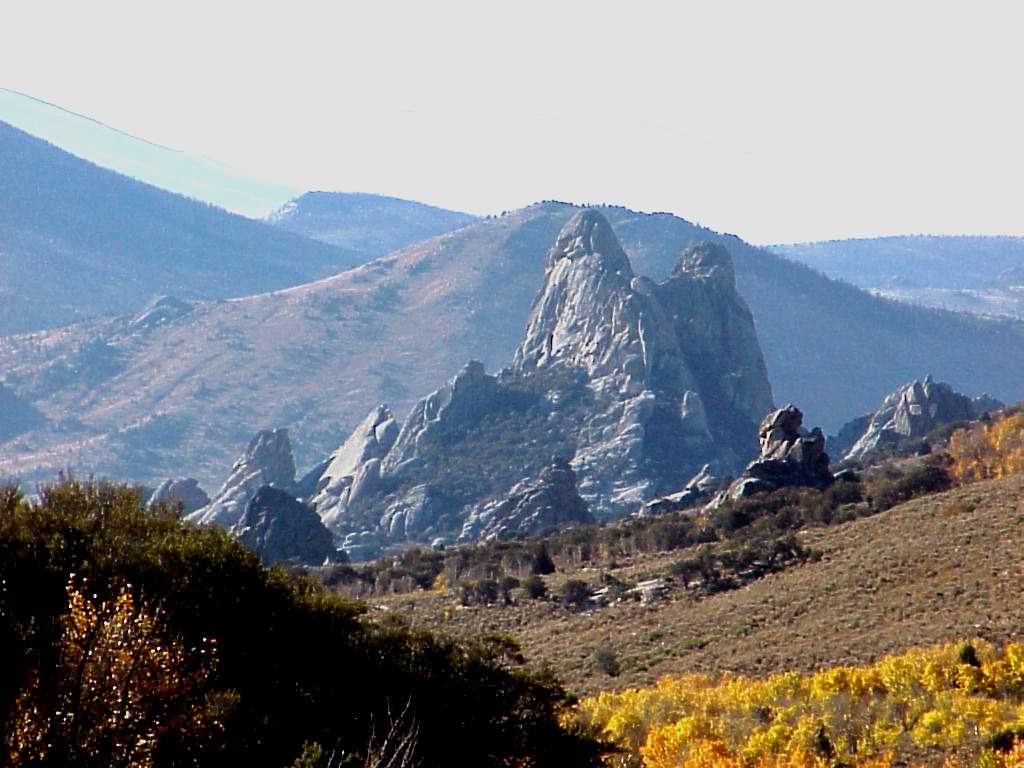
 View from within the City of Rocks.
 Bath Rock in the City of Rocks National Reserve in Idaho State.
The landscape of City of Rocks has been sculpted from granite that was intruded into the crust during two widely spaced times. The granite that composes most of the spires is part of the 28 million year old Almo pluton. However, some of the spires are made of granite that is part of the 2.5 billion year old Green Creek Complex that contains some of the oldest rocks in the western United States. The granite has eroded into a fascinating assortment of shapes.
City of Rocks was designated a National Reserve, a unit of the National Park Service, in recognition of the nationally significant geological and scenic values of its rock formations and the historical significance of the California Trail. Rock formations in the reserve developed through an erosion process called exfoliation, during which thin rock plates and scales sloughed off along joints in the rocks. The joints, or fractures, resulted from the contraction of the granite as it cooled, from upward expansion of the granite as overlying materials were eroded away, and from regional tectonic stresses. The granite has eroded into a fascinating assortment of shapes as high as 600 feet (180 m). The upper surfaces of many of the rocks are covered with flat-floored weathering pits known as panholes. The most notable panhole is located on top of Bath Rock and is continuously filled with water from rain or snow melt.
Animals
Located in the Northern Basin and Range/Snake-Columbia shrub steppe ecoregions and the Raft Watershed[9] of the Upper Snake River Basin, the habitat of the reserve supports a large variety of mammals, birds, reptiles, and invertebrates.
- Amphibians - Common amphibians that could be found near water include Boreal Toad, Great Basin Spadefoot Toad, and Northern Leopard Frog.
- Birds - The reserve provides excellent breeding and prey habitat for many raptor species including Golden Eagle, Prairie Falcon, Red-tailed Hawk, Northern Harrier, Sharp-shinned Hawk, Cooper's Hawk, American Kestrel, Turkey Vulture, and Great Horned Owl. Swainson's Hawk and Ferruginous Hawk are less abundant in the reserve. Other common bird species includes Sage Grouse, Pinon Jay, Clark's Nutcracker, Common Nighthawk, Rock Doves, Mourning Doves, Cliff Swallow, Mountain Bluebird, Hermit Thrush, Mountain Chickadee, Rock Wren, House Wren, Solitary Vireos, Warbling Vireos, Green-tailed Towhee, Virginia's Warbler, Brewer's Blackbird, and various Sparrows.
- Mammals - A partial list of mammals in the reserve includes, Mountain Lion, Mule Deer, Coyote, Bobcat, Badger, , Yellow-bellied marmot, Cliff Chipmunk, Mountain Cottontail Rabbit, , Black-tailed Jackrabbit, Snowshoe Hare, Northern Grasshopper Mouse, Merriam Shrew, several species of voles, and a variety of bats. Pronghorn antelope and bison were probably common a century ago.
- Reptiles - Typical lizard species include the western whiptail, western fence lizard, Long-nosed leopard Lizard, Sagebrush Lizard, and Northern Desert Horned Lizard. Snakes include the Western Rattlesnake, Great Basin Gopher Snake, Striped Whipsnake, and Wandering Garter Snake. The Western Rattlesnake is the only strongly venomed snake found in the reserve.
Plants
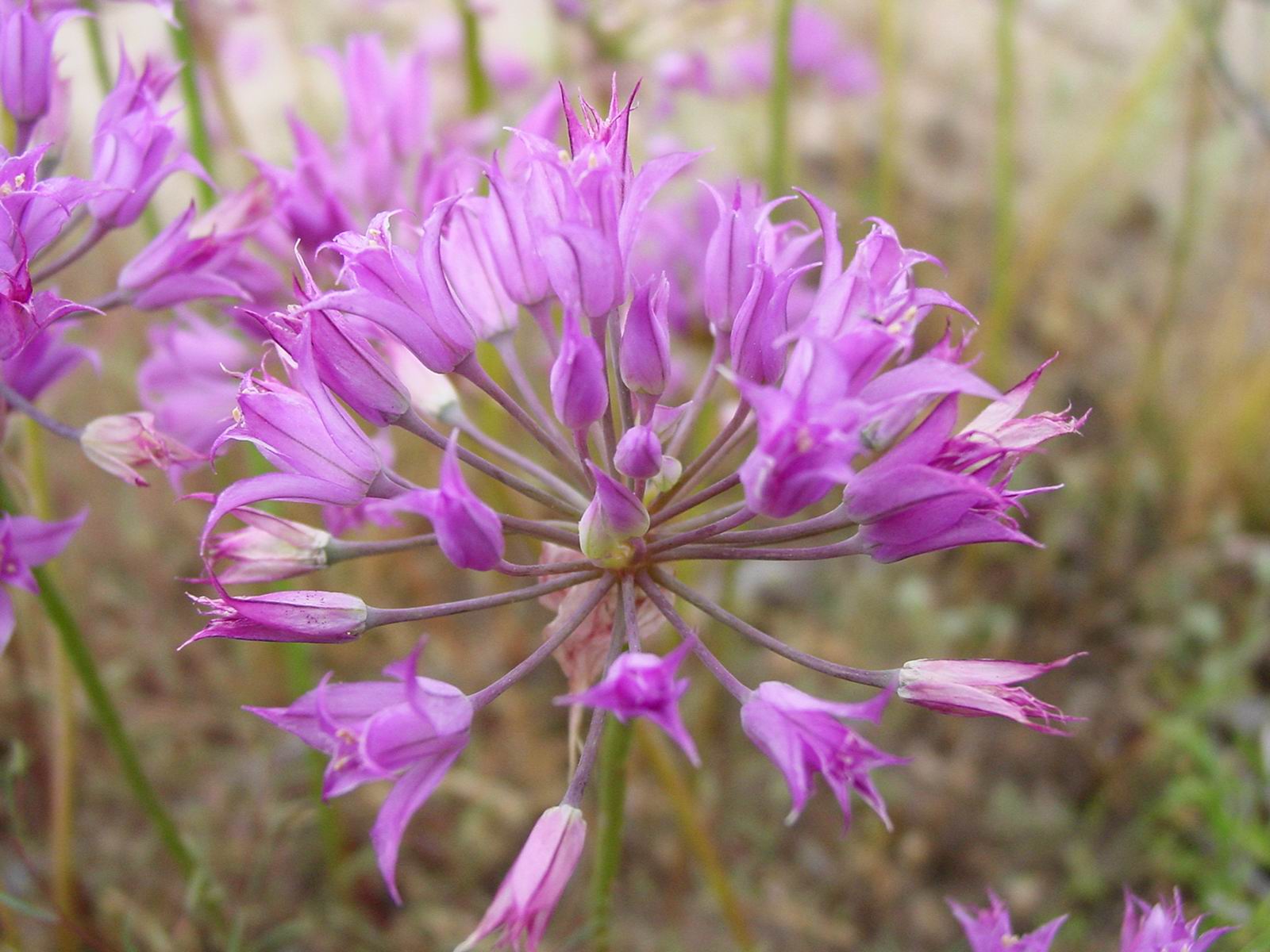
 Allium acuminatum is a wild onion found in City of Rocks
Notable plant life includes:
- The Kruckeberg's sword fern is found in the cool, moist micro-habitats in the granite formations. The fern grows in rock crevices and is normally found at higher elevations than City of Rocks. Primary threats to this species are trampling and or removal by visitors along rockclimbing routes.
- Stands of piñon/juniper woodlands are dominated by the single-leaf piñon pine and Utah juniper, interspersed with mountain big sagebrush and curl-leaf mountain mahogany. The pinon seed is edible and gathered by local residents. Higher slopes are covered with mountain big sagebrush, snowberry, serviceberry, and bitterbrush, with other shrubs, grasses, and herbs growing in the openings between shrubs. Groves of aspen, stands of douglas-fir and lodgepole pine, are located on the upper stony / grassy slopes of the reserve. Quaking aspen groves occur in canyons containing streams.
Other dominant plants in the City of Rocks National Reserve include:
- Piñon / juniper woodlands and forest
- Conifer / aspen woodlands and forests
- Riparian scrub and herbaceous wetlands
- Big sagebrush and grasslands
- Mixed scrub
- Mountain mahogany scrubs
- High elevation meadows
- Other unvegetated areas
Weather
The semi-arid climate is characterized by low to moderate precipitation, great extremes in both daily and seasonal temperatures, and low relative humidity. Average annual precipitation is approximately 14 inches (360 mm) at the lower elevations and 22 inches (560 mm) in the highest areas. Average snow depths for higher elevations range between 35 and 68 inches (1.7 m). Summers are hot and dry with occasional thunderstorms.
Mountains
The reserve is in the southern part of the Albion Mountains, bordered on the east by the Raft River valley and to the north by the Snake River valley. Elevations rise from 5,650 feet (1,720 m) where Circle Creek meets the reserve boundary to 8,867 feet (2,703 m) at the top of Graham Peak to the north.
Soils
The majority of the soils in the reserve are composed of grus, a coarse angular sand derived from the disintegration of the underlying granitic bedrock. They are highly erodible. Soil erosion is greatest near roads and on steep slopes and intermittent stream channels. Erosion in these areas has formed deep gullies. Some of the exposed soil banks are over 8 feet (2.4 m) high.
See also
References
- ^ "Listing of acreage as of 12/31/2010". Public Use Statistic Office, National Park Service. http://www.nature.nps.gov/stats/Acreage/acrebypark10cy.pdf. Retrieved 2011-07-09.
- ^ "Five Year Annual Recreation Visits Report". Public Use Statistic Office, National Park Service. http://www.nature.nps.gov/stats/viewReport.cfm?selectedReport=SystemComparisonReport.cfm. Retrieved 2011-07-09.
- ^ a b "City of Rocks National Preserve". NPS.gov. http://www.nps.gov/ciro/. Retrieved 2010-09-06.
- ^ "Granite Pass USGS Cotton Thomas Basin Quad, UT,ID, Topographic Map". Trails.com. http://www.topozone.com/map.asp?lat=41.9922&lon=-113.85&datum=nad27&u=4&layer=DRG&size=m&s=200. Retrieved 24 September 2010.
- ^ Lyndia Carter (December 1996). "The Salt Lake Cutoff and the California Trail". History Blazer. Utah.gov. http://historytogo.utah.gov/utah_chapters/trappers,_traders,_and_explorers/thesaltlakecutoffandthecaliforniatrail.html. Retrieved 24 September 2010.
- ^ "Emigrant Canyon USGS Almo Quad, Idaho, Topographic Map". Trails.com. http://www.topozone.com/map.asp?lat=42.0217&lon=-113.673&datum=nad27&u=4&layer=DRG&size=m&s=200. Retrieved 24 September 2010.
- ^ John Hayward. "A Physical, Political & Economic Description of the Utah Territory and Salt Lake City". A Gazetteer of the United States of America. Central Pacific Railroad Photographic History Museum. http://cprr.org/Museum/Utah_1851.html. Retrieved 24 September 2010.
- ^ "City of Rocks and Granite Pass" (pdf). http://history.idaho.gov/Reference%20Series/0126.pdf. Retrieved 2010-09-06.
- ^ "Raft Watershed -- 17040210". Raft your Watershec. United States Environmental Protection Agency. http://cfpub.epa.gov/surf/huc.cfm?huc_code=17040210. Retrieved 24 September 2010.
External links
- City of Rocks National Reserve from the National Park Service
- City of Rocks National Reserve from the Idaho Department of Parks and Recreation
Federal National ParksNational MonumentsNational ForestsBitterroot • Boise • Caribou-Targhee • Clearwater • Coeur d'Alene • Idaho Panhandle • Kaniksu • Kootenai • Nez Perce • Payette • Salmon-Challis • Sawtooth • St. Joe • Wallowa–Whitman • Wasatch-CacheNational Wildlife RefugesBear Lake • Camas • Deer Flat • Grays Lake • Kootenai • Minidoka • Oxford Slough Waterfowl Production AreaBig Jacks Creek • Bruneau-Jarbidge Rivers • Craters of the Moon • Frank Church-River of No Return • Gospel Hump • Hells Canyon • Little Jacks Creek • North Fork Owyhee • Owyhee River • Pole Creek • Selway-Bitterroot • SawtoothState Bear Lake • Bruneau Dunes • Castle Rocks • City of Rocks • Coeur d'Alene Parkway • Dworshak • Eagle Island • Farragut • Harriman • Hells Gate • Henrys Lake • Heyburn • Lake Cascade • Lake Walcott • Land of the Yankee Fork • Lucky Peak • Massacre Rocks • McCroskey • Old Mission • Ponderosa • Priest Lake • Round Lake • Thousand Springs • Three Island Crossing • Trail of the Coeur d'Alenes • Winchester Lake •Idaho Department of Parks & Recreation (website)U.S. National Register of Historic Places Topics Lists by states Alabama • Alaska • Arizona • Arkansas • California • Colorado • Connecticut • Delaware • Florida • Georgia • Hawaii • Idaho • Illinois • Indiana • Iowa • Kansas • Kentucky • Louisiana • Maine • Maryland • Massachusetts • Michigan • Minnesota • Mississippi • Missouri • Montana • Nebraska • Nevada • New Hampshire • New Jersey • New Mexico • New York • North Carolina • North Dakota • Ohio • Oklahoma • Oregon • Pennsylvania • Rhode Island • South Carolina • South Dakota • Tennessee • Texas • Utah • Vermont • Virginia • Washington • West Virginia • Wisconsin • WyomingLists by territories Lists by associated states Other Categories:- IUCN Category V
- California Trail
- Landforms of Cassia County, Idaho
- Protected areas of Cassia County, Idaho
- Climbing areas of the United States
- Idaho state parks
- National Historic Landmarks in Idaho
- National Natural Landmarks in Idaho
- National Reserves of the United States
- Protected areas established in 1988
- Rock formations in Idaho
- United States National Park Service areas in Idaho


Wikimedia Foundation. 2010.