- City and County of Swansea Council
-
City and County of Swansea Council 
The Logo of the City and County of Swansea council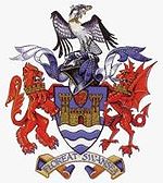
The Arms of the City and County of SwanseaControl Liberal Democrats/Independent Coalition MPs AMs - Edwina Hart
- Mike Hedges
- Julie James
Official Website swansea.gov.uk The City and County of Swansea Council (Welsh: Cyngor Dinas a Sir Abertawe) is the governing body for one of the Principal Areas of Wales covering Swansea, Gower and the surrounding area. The council consists of 72 councillors representing 36 electoral wards.
The council is currently controlled by the Liberal Democrats and is led by Councillor Christopher Holley.
Contents
Political makeup
Elections take place every four years. The last election was 1 May 2008.[2]
Current composition
Group affiliation[1] Members Labour 27 Liberal Democrat 24 Independent 7 Independents@Swansea 6 Conservative 4 Communities of Swansea 3 Plaid Cymru 1 Total 72 Historic results
Year Labour Conservative Liberal Democrats Plaid Cymru Others Turnout Notes 2008 30 4 23 1 14 38.19% NOC, Swansea Administration controlled 2004 32 4 19 5 12 38.32% NOC, Swansea Administration controlled 1999 45 4 11 3 9 Labour controlled 1995 Labour controlled source: [3]
Between 1996 and 2004, the council was under Labour control. Since 2004 there has been no overral control and the council has been led by a Liberal Democrats coalition with an alliance with the Independents and the Conservatives, termed the Swansea Administration. However these figures changed during the 2004-2008 period with the defection of Cllr. Keith Morgan from Plaid Cymru to the Welsh Liberal Democrats in 2005 and Cllr. Rene Kinzett from the Welsh Liberal Democrats to the Conservatives in 2006.
Following the 2008 elections, the Liberal Democrats agreed with the Independents to form another coalition for the next four years.
Municipal History
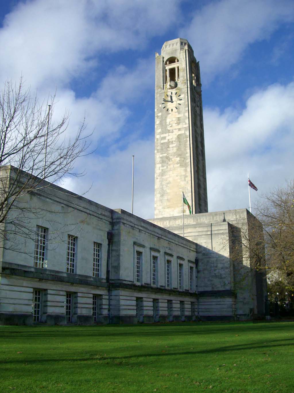
 The Guildhall - council headquarters
Swansea's first charter was granted sometime between 1158-1184 by William de Newburgh, 3rd Earl of Warwick. The charter gave Swansea the status of a borough, granting the townsmen, called burgesses certain rights to develop the area. A second charter was granted in 1215 by King John. By 1888, the borough acquired the status of county borough, separating it from the administrative county of Glamorgan.
In 1974, under the Local Government Act 1972, Swansea (which had previously been a county borough) was merged with Gower Rural District, to become a district of West Glamorgan called the District and City of Swansea. In 1996, another local government reform saw the district of Swansea merged with parts of the Lliw Valley district to form a unitary authority under the name of the 'City and County of Swansea' (Welsh: Dinas a Sir Abertawe.)
Mayoralty
The mayor of Swansea is a senior member of the elected Council. The style of the mayor is "The Right Worshipful the Lord Mayor of Swansea". The Lord Mayor's official residence is the Mansion House in Ffynone.
Municipal Year Mayor 2010–2011 Richard Lewis 2009–2010 Alan Lloyd 2008–2009 Gareth Sullivan 2007–2008 Susan Waller 2006–2007 Chris Holley 2005–2006 Mair Gibbs Electoral divisions
 Electoral ward map of Swansea
The city is divided into 36 electoral wards. Most of these wards are coterminous with communities (parishes) of the same name. Each community can have an elected council. The following table lists council wards, communities and associated geographical areas. Communities with a community council are indicated with a '*':
Map # Ward Communities (Parishes) Places covered # Councillors Population (*1) Land Area (km²) Population density (ppl/km²) 1 Bishopston Bishopston* Barland Common, Caswell, Bishopston, Clyne Common, Manselfield, Murton, Oldway 1 3,341 5.89 567 2 Bon-y-maen Bon-y-maen Pentrechwyth, Pentre Dwr, Winch Wen 2 6,342 8.47 749 3 Castle Castle Swansea city centre, Brynmelin, Dyfatty, Maritime Quarter, parts of Mount Pleasant and Sandfields 4 11,933 3.03 3,938 4 Clydach Clydach* Clydach, Faerdre, Glais (East) and Penydre 2 7,320 8.46 865 5 Cockett Cockett Cadle, Cwmdu, Coedweig, Gendros, Gors, Fforestfach, Waunarlwydd 4 12,586 8.6 1,464 6 Cwmbwrla Cwmbwrla Brondeg, Brynhyfryd, Cwmdu, Gendros, Manselton 3 8,217 1.5 5,478 7 Dunvant Dunvant Dunvant, Killay 2 4,679 2.41 1,941 8 Fairwood Upper Killay*, Three Crosses ward of the community of Llanrhidian Higher* Upper Killay, Three Crosses 1 2,774 13.44 206 9 Gorseinon Gorseinon Central and Gorseinon East wards of the community of Gorseinon* Gorseinon town 1 3,275 2.23 1,469 10 Gower The Communities of: - Ilston*,
- The community of Llangennith, Llanmadoc and Cheriton *,
- Llanrhidian Lower*,
- Penrice*,
- Port Eynon*,
- Reynoldston,*
- Rhossili*
Cheriton, Fairyhill, Horton, Knelston, Landimore, Llanddewi, Llangennith, Llanmadoc, Llanrhidian, Middleton, Nicholaston, Oldwalls, Overton, Oxwich Green, Oxwich, Parkmill, Penmaen, Penrice, Port Eynon, Reynoldston, Rhossili, Grovesend, Llanmorlais, Pentrebach, Pont-Lliw, Poundffald, Slade 1 3,654 113.2 32 11 Gowerton Gowerton* Gowerton village, Penclawdd, Waunarlwydd 1 4,928 7.55 653 12 Killay North Killay* (North ward) Carnglas, Olchfa and Waunarlwydd 1 3,436 1.99 1,727 13 Killay South Killay* (South ward) Dunvant, Ilston, Sketty 1 2,297 1.24 1,852 14 Kingsbridge Llwchwr* (Garden Village and Kingsbridge wards) Garden Village, Stafford Common 1 4,089 4.82 848 15 Landore Landore Hafod, Landore, Morfa, Plasmarl 2 6,121 2.23 2,745 16 Llangyfelach - Llangyfelach*
- Pontlliw*
Pantlasau, Tircoed 1 4,426 17.12 259 17 Llansamlet Llansamlet, Birchgrove Birchgrove, Glais, Heol Las, Llansamlet, Morriston, Talycoppa and Trallwn 4 12,003 15.54 772 18 Lower Loughor Llwchwr* (Lower Loughor ward) Loughor 1 2,146 1.61 1,767 19 Mawr Mawr* Felindre, Craigcefnparc, Garnswllt, Ryhdypandy 1 1,800 57.81 31 20 Mayals Mumbles* (Mayals ward) Blackpill, Mayals, West Cross 1 2,834 4.52 627 21 Morriston Morriston* Caemawr, Cwmrhydyceirw, Morriston town, Parc Gwernfadog, Pant-lasau, Ynysforgan and Ynystawe 5 16,781 7.32 2,292 22 Mynydd-Bach Mynydd-Bach Clase, Clasemont, Park View Estate, Penfillia Estate, Treboeth, Tirdeunaw, Pinewood, Mynydd Garnlywd and Bryn Rock 3 8,756 3.57 2,453 23 Newton Mumbles* (Newton ward) Caswell, Langland Bay 1 3,150 2.36 1,335 24 Oystermouth Mumbles* (Oystermouth ward) Norton, Mumbles, Thistleboon 1 4,315 2.01 2,147 25 Penclawdd Llanrhidian Higher* (Llanmorlais and Penclawdd wards) Blue Anchor, Llanmorlais, Penclawdd, Crofty and Wernffrwd 1 3,672 14.3 257 26 Penderry Penderry Penlan, Portmead, Blaen-y-Maes, Fforesthall and Caereithin 3 10,981 4.04 2,718 27 Penllergaer Penllergaer* Penllergaer and part of Gorseinon 1 2,434 6.01 405 28 Pennard Pennard* Bishopston, Fairwood Common, Kittle, Parkmill, Southgate 1 2,648 11.64 227 29 Penyrheol - Grovesend*
- Gorseinon* (Gorseinon West and Penyrheol wards)
Grovesend and Waun Gron 2 5,780 8.61 671 30 Pontarddulais Pontarddulais* Pontarddulais town 2 5,293 15.61 339 31 St. Thomas St. Thomas Bon-y-maen, Dan-y-graig, Landore, Port Tennant, SA1 Waterfront, Swansea Docks, Kilvey Hill and the Grenfell Park Area, St. Thomas 2 6,373 5.91 1,078 32 Sketty Sketty Carnglas, Clyne Valley (Gwerneinon), Derwen Fawr, Hendrefoilan, Killay, Singleton Park, Sketty village, Tycoch, Cwmgwyn 5 13,799 6.87 2,009 33 Townhill Townhill Cwm-Gwyn, Mayhill, Mount Pleasant, Townhill 3 8,443 1.8 4,691 34 Uplands Uplands Brynmill, St. Helens, Cwmgwyn, Ffynone and The Lons, Uplands 4 13,355 2.31 5,781 35 Upper Loughor Llwchwr* (Upper Loughor ward) Loughor 1 2,845 1.61 1,767 36 West Cross Mumbles* (West Cross ward) Manselfield, Norton, Mumbles and Newton, West Cross Remove Manselfield from the West Cross Ward. It is within the Bishopston Ward. As shown.
2 6,475 2.48 2,611 *1 - 2001 Census
Corporate Identity
Logo
The logo of the City and County of Swansea depicts a stylised Osprey. It is sometimes shown with the name the council written beneath it or written in a ring around the Osprey pictogram.
Coat of arms
The official coat of arms used by the council today were granted by the College of Arms in 1922. The motto is 'Floreat Swansea'.
The Arms are blazoned as follows:
- Per Fess wavy Azure and barry wavy of six Argent, of the first a double-towered Castle or, in Chief on an Inescutcheon of the third a Lion passant guardant Gules; And for the Crest, On a Wreath of the Colours an Osprey rising holding in the Beak a Fish proper; Supporters: on the dexter side a Lion Gules gorged with a Mural Crown or, and on the sinister side a Dragon Gules gorged with a Mural Crown or'.
The Arms are symbolic to an extent: the blue and white wavy bars represent the sea, since Swansea is a port town; the Castle represents the Medieval fortifications of the Town; the lion as dexter supporter and on the Inescutcheon commemorates the link with the de Breos family; and the dragon as sinister supporter is the National Emblem of Wales and is a supporter in the Achievement of Arms of the present Lord Swansea.
In April 1974, the City of Swansea was merged with the Gower Rural District to form the new District and City of Swansea. The Arms granted to the Corporation of the County Borough of Swansea in 1922 were transferred unchanged to the new City Council in May 1975. The Certificate of Transfer of the College of Arms dated 11 March 1976 confirmed the re-granting of the Arms. With the 1996 reorganisation of local government, the arms were transferred a second time to the present City Council.[2]
Local education authority
The council serves as the local education authority for schools based within the unitary authority area.
Schools
Top performing secondary schools in City and County of Swansea, based on 5 GCSEs, A-C Grade, according to the latest inspection reports from Estyn
- 79% Bishopston Comprehensive School, Bishopston
- 72% Olchfa Comprehensive School, Sketty
- 72% Ysgol Gyfun Gwyr, Gowerton,(Welsh)
- 64% Bishop Vaughan Catholic Comprehensive School, Morriston
- 56% Pontarddulais Comprehensive School, Pontarddulais
- 51% Gowerton Comprehensive School, Gowerton
- 51% Penyrheol Comprehensive School, Gorseinon
- 45% Birchgrove Comprehensive School, Birchgrove
- 44% Bishop Gore School, Sketty
- 43% Morriston Comprehensive School, Morriston
- 40% Pentrehafod School, Hafod
- 34% Cefn Hengoed Community Comprehensive, Winch Wen
- 14% Daniel James Community School, Treboeth
- 5% Dylan Thomas Community School, Cockett
Ysgol Gyfun Bryntawe is a new Welsh Medium Comprehensive School which opened in 2003. Their GCSE results will be published in late 2008 after Y11 sit their exams. According to the latest Estyn inspection the school scored Grade 1 in most areas that were tested, so exam results are anticipated to be exceptional. The Times newspaper called it 'one of leading schools in the country'. [4]
Council premises
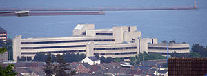 Civic Centre overlooking Swansea Bay
- Civic Centre née County Hall
- Guildhall
- Mansion House
- Penllergaer Civic Centre
See also
References
- ^ [1]
- ^ The Local Authorities (Armorial Bearings) (No. 2) (Wales) Order 1996 (1996 No. 1930 ) (OPSI website), accessed October 2, 2007
External links
Local authorities of Wales Anglesey • Blaenau Gwent • Bridgend • Caerphilly • Cardiff • Carmarthenshire • Ceredigion • Conwy • Denbighshire • Flintshire • Gwynedd • Merthyr Tydfil • Monmouthshire • Neath Port Talbot • Newport • Pembrokeshire • Powys • Rhondda Cynon Taf • Swansea • Torfaen • Vale of Glamorgan • Wrexham
Categories:- Swansea
- Local authorities of Wales


Wikimedia Foundation. 2010.