- Mandaluyong
-
City of Mandaluyong
Lungsod ng Mandaluyong— Highly-Urbanized City — Shaw Boulevard

SealNickname(s): Shopping Mall Capital of the Philippines.Tiger City Motto: Sa Pagkaka-isa may Pag-unlad
(English: In Unity there is Progress)Map of Metro Manila showing the location of Mandaluyong.
Country Philippines Region National Capital Region District Lone District of Mandaluyong City Barangays 27 Cityhood 9 February 1994 Government – Mayor Benjamin D.C. Abalos, Jr. (Lakas-Kampi-CMD) – Vice Mayor Danilo L. De Guzman (Lakas-Kampi-CMD/Liberal-Aksyon) – Sangguniang Panlungsod CouncilorsArea – Total 21.26 km2 (8.2 sq mi) Population (2007) – Total 305,576 – Density 14,373/km2 (37,225.9/sq mi) Website www.mandaluyong.gov.ph The City of Mandaluyong (Filipino: Lungsod ng Mandaluyong) is one of the cities and municipalities that comprise Metro Manila in the Philippines. It is bordered on the west by the country's capital, Manila, to the north by San Juan City, to the east by Quezon City and Pasig City, and by Makati City to the south. At present, its nicknames are "Tiger City of the Philippines", "Metro Manila's Heart", and the "Shopping Mall Capital of the Philippines".
Mandaluyong City is located right at the center of Metro Manila. Among the many attractions in the city is the western half of the Ortigas Center, one of the major centers of business and commerce in the metropolis (the eastern half is in Pasig City). Found within the Mandaluyong portion of the Ortigas Center is the main headquarters of the Asian Development Bank, Banco De Oro, and the headquarters of San Miguel Corporation, Southeast Asia's largest food and beverage company. One of the most prominent pharmaceutical laboratories and factories, the UniLab, is located here.
Contents
Etymology
 Mandaluyong City Skyline as seen from Greenhills in San Juan
There are different stories on the origin of the name “Mandaluyong”. One tells of the early days when the place abound with a kind of tree called luyong from which beautiful canes and home furniture were made. Another claimed that the Spaniards named the place Mandaluyong based on the report of what a navigator named Acapulco saw that the rolling hills were frequently lashed at by daluyong (“big waves from the sea”). This seems to give credence to traditional stories before the coming of the Spaniards that giant waves from the sea lashed at the adjoining hills of the vast lowland, referred to as “Salpukan ng Alon”. Father Felix dela Huerta, a Franciscan Historian, observed that the rolling topography of this land resembled giant waves of the sea. Hence, natives replying to the question of strangers as to what the place was called, used to answer Madaluyong, later hispanized by Spanish writers into Mandaluyong by affixing the consonant “n” to the first syllable.
Romantic residents, however, peddled the story of a Maharlika named Luyong who fell in love with Manda, the lovely daughter of a barangay chieftain. The chieftain had no personal liking for Luyong and forbade his daughter’s marriage to him. Luyong overcame the objection of Manda’s father by winning a series of tribal contests which was the custom at the time. The couple settled thereafter in a place which was later called “Mandaluyong” literally named after “Manda” and “Luyong”.
History
Mandaluyong formed part of what was once the Kingdom of Sapa of the Great Majapahit Empire around 1300. More than a century later, around 1470, it expanded and was called the Kingdom of Namayan. The vast kingdom comprised what are now Quiapo, San Miguel, Sta. Mesa, Paco, Pandacan, Malate and Sta. Ana in Manila, and Mandaluyong, San Juan, Makati, Pasay, Pateros, Taguig, Parañaque, and portions of Pasig and Quezon City up to Diliman.
Mandaluyong was first known as a barrio of Sta. Ana de Sapa which was part of the District of Paco, Province of Tondo. Named San Felipe Neri by the Spaniards in honor of the Patron Saint of Rome, it was separated from Sta. Ana de Sapa in 1841.
During the American period, San Felipe Neri was consolidated with the municipality of San Juan del Monte. For several months in 1904, San Felipe Neri became the capital of Rizal province.
However in 1907, San Felipe Neri became an independent municipality with its separation from San Juan. It was renamed the Municipality of Mandaluyong by virtue of House Bill No. 3836. It achieved city status in 1994.
Culture and Tourism
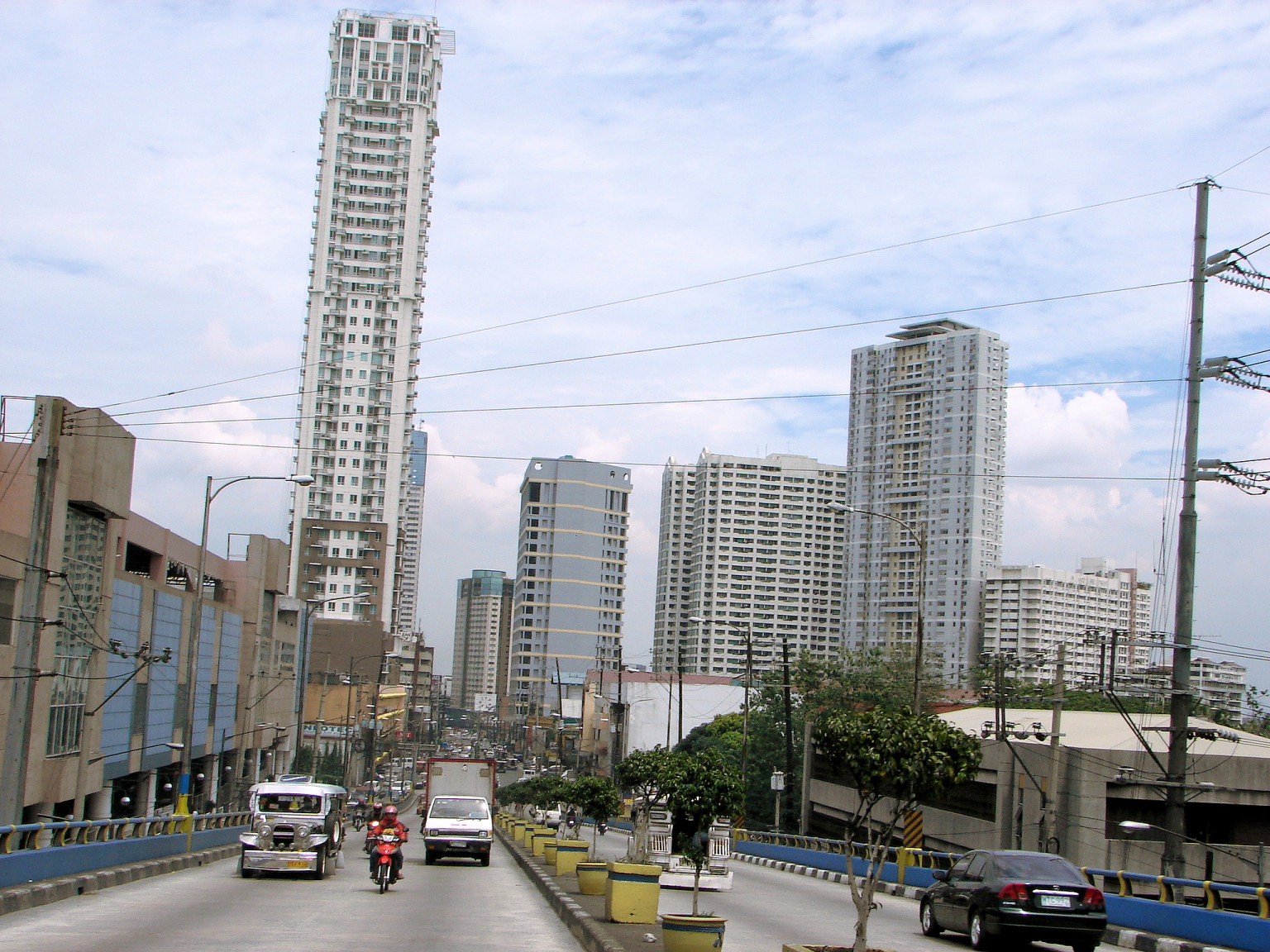
 Shaw Boulevard is one of the major roads in Mandaluyong.
Mandaluyong is deemed as the "Shopping Mall Capital of the Philippines" because of its notable number of shopping and entertainment hubs. Located in Ortigas Center is Shangri-La Place, a residential and entertainment district owned by Shangri-La Hotels and Resorts. It comprises Edsa Shangri-La Manila, St. Francis Towers (one of the tallest residential towers in the Philippines when built) and Shangri-La Plaza (the only retail arm of the Shangri-La Group in the world) with stores like Gucci, Calvin Klein, Burberry, Dolce and Gabbana, Hugo Boss and Polo Ralph Lauren. To the north is St. Francis Square, SM Megamall (one of the biggest shopping malls and the premier mall of the largest mall chain in Asia) and the upscale retail arm of SM Malls, the Podium.For the blue-collar and low-cost consumers, there's EDSA Central and Star Mall to the Southwest. The Shaw Boulevard MRT Station of the MRT is a shopping hub itself, besides the fact that the station is connected to three other malls (Star Mall, Shangri-La Plaza and the newly renovated EDSA Central). Along EDSA is the Robinson's Place Pioneer, owned by the second largest retail company in the country. Another entertainment hub is Liberty Center along Shaw Boulevard, which consists of Puregold supermarket, Yonex Badminton Court, a row of restaurants and establishments and home to the newly-constructed Liberty Park which holds nightly performances from different bands and musicians. Along Shaw Boulevard is the Wack Wack Golf and Country Club, considered as one of the finest golf courses in the world.
Among locals, Mandaluyong City is often used in jokes and puns pertaining to a person's mental health (e.g., a person whose mental well-being is suspect is often labeled as coming from Mandaluyong, the joke going "sa loob o sa labas?, which translated, means "inside or outside?"). This is because the National Center for Mental Health, the country's premier mental health center, is found within the city.
Economy
Commercial Activities
Typical of cities in metropolitan areas, Mandaluyong has its own share of commercial strips and a central business district.
The former, consisting mostly of banks (Map ~ Financial Institutions), offices and service establishments, stretch along public transport routes thereby serving both local consumers and passers-by from the neighboring localities.
Major commercial strips of the city include the stretch of Boni Avenue, Shaw Boulevard, Libertad-Sierra Madre area, Kalentong, San Francisco, part of Martinez, Sgt. Bumatay towards Barangka Drive and Pinatubo towards EDSA.
Shopping Malls
- SM Megamall
- Shangri-La Plaza
- The Podium
- Robinson's Place Pioneer Forum
- EDSA Central Pavilion
- StarMall
- Liberty Center
- Madison Square
- Marketplace Mall
- Robinson's Place Galeria
- St. Francis Square Mall
Hotels
- Edsa Shangri-La Manila
- Legend Villas
- New Horizon Hotel
- Lancaster Hotel
- Sogo Hotel
- Nice Hotel
- Bermuda Hotel and Restaurant
Real Estates
- California Garden Square
- San Francisco Gardens
- DMCI Homes
- SMDC Light Residences Pioneer
- Mahogany Mansion
- Palo Verde Dansalan Gardens
- Bonifacio Residences
- Sunshine 100 Pioneer
- Pioneer Highlands 1
- Gateway Garden Heights
- Axis Residences
- Two Gateway Place
- Pioneer Woodlands
- Shaw Residenza
Subdivisions
- MerryLand Subdivision
- PrinceVille TownHomes
- Ayala Homes
- Acropolis Subdivision
- DreamLand Subdivision
Supermarkets
- Robinson's Supermarket California Garden Square
- SM Hypermarket Shaw Boulevard
- Puregold Supermarket Shaw Boulevard
- Rustan's Express Supermarket
- Topway Supermarket
Television Station
- TV5 Media Center
Industrial Activities
These activities are mostly concentrated within the EDSA-Shaw-Pioneer area and along Pasig River.
Although prominent in the manufacture of foods, medicines and laboratory equipment, these industries are gradually declining in number, opting to relocate in newly-developed industrial zones outside Metropolitan Manila.
In the Pasig River area, particularly in Barangays Namayan and Mabini J. Rizal, areas formerly industrial are now the sites for residential subdivisions and townhouses.
In the EDSA-Shaw-Pioneer area, the transformation is toward a more economically profitable and globally competitive commercial activity.
Factories & Industries
- Hewlett Packard Philippines
- Commonwealth Foods, Inc.
- United Laboratories (UNILAB)
- Puma Spring and Rubber Industries
Barangays
Mandaluyong is politically subdivided into 27 barangays.
District Barangay Land Area
(has.)Population
(2007)[1]1 Addition Hills 121.19 81,221 1 Bagong Silang 14.26 3,747 2 Barangka Drive 24.54 12,134 2 Barangka Ibaba 16.92 9,372 2 Barangka Ilaya 47.45 4,185 2 Barangka Itaas 17.21 11,212 2 Buayang Bato 7.26 999 1 Burol 2.78 2,322 1 Daang Bakal 17.34 2,980 1 Hagdan Bato Itaas 18.36 9,431 1 Hagdan Bato Libis 15.48 6,241 1 Harapin Ang Bukas 4.89 4,069 1 Highway Hills 105.12 18,682 2 Hulo 29.30 20,850 2 Mabini-J. Rizal 11.88 4,826 2 Malamig 29.52 6,898 1 Mauway 60.06 21,700 2 Namayan 30.60 4,846 1 New Zañiga 21.96 5,413 2 Old Zañiga 42.48 6,674 1 Pag-Asa 12.60 3,112 2 Plainview 115.92 24,706 1 Pleasant Hills 20.33 6,495 1 Poblacion 24.12 14,778 2 San Jose 3.18 7,629 2 Vergara 15.12 4,928 1 Wack-Wack Greenhills 294.48 6,126 Health
Mandaluyong has several private and public hospitals & health center, namely the privately owned Dr. Victor R. Potenciano Medical Center along EDSA and Unciano General Hospital on Boni Avenue, and the government hospital Mandaluyong City Medical Center also on Boni Avenue. The city is also home to the Philippine’s prime psychiatric health institution, the National Center for Mental Health located along Nueve De Febrero Street. Many residents, specifically the middle-to-upper class medical clientele visits the nearby Medical City in Ortigas Center.
The Dr. Victor R. Potenciano Medical Center is a tertiary care hospital that has a 189-bed capacity within its 10-storey hospital building. It is the first ISO certified hospital in Metro Manila. The hospital specializes in internal medicine, surgery, obstetrics – gynecology, pediatrics, ophthalmology, otorhinolaryngology, oncology, and orthodontics. Its specialized centers, such as the oncology center, heart station and cardiac rehab center, respiratory care center, breast clinic, ICU, pediatric ICU, and maternal ICU, are equipped with modern medical facilities together with physicians highly trained in their fields. Complementing these is the 5-storey Physicians’ Center, which houses the doctors’ clinics and other important lectures.
Education
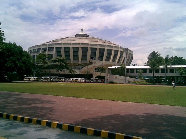
 St. Benilde Gymnasium in La Salle Green Hills
Three major colleges and universities are located in Mandaluyong, namely: Don Bosco Technical College, Jose Rizal University and Rizal Technological University (the only state-owned university in the city).
Don Bosco Technical College (DBTC or Don Bosco Mandaluyong) is a private Catholic higher-education institution, owned and operated by the Salesians of Don Bosco that offers all-boys grade school and high school education, and co-educational tertiary education. The school, established in 1953, also offers vocational couses through the Manpower Skills & Training Center. Its College department specializes in engineering and technical courses, while the High School and Grade School Departments offer a dual-curriculum (Academic and Technical) and a Science specialization to help students nourish their skills in whatever field they choose to pursue in the future. It is situated on the historic grounds of the former the site of the Katipuneros, that evolved into the San Carlos Seminary, right before housing DBTC's campus.
A good number of city officials of Mandaluyong are alumni of Don Bosco,[2] including incumbent City Mayor, Hon. Benjamin Abalos, Jr. (HS '79);[3] former Vice Mayor, Hon. Renato Sta. Maria (HS '65);[4] City Councilors Edward Bartolome (HS '96),[5] Noel Bernardo (HS '79),[6] and Jonathan Abalos (HS '85).[7] Other notable alumni include "King of Pinoy Rap," Francis Magalona (HS '81);[8] and actor Ricky Davao (HS '78).[9]
The Plaridel Campus of Arellano University, a private nonsectarian university is an institution for secondary and higher education, located along New Panaderos Extension.
Another institution for higher education in the city is Jose Rizal University (JRU), which is a private nonsectarian university found along Shaw Boulevard. Its broad spectrum of degree programs includes the fields of engineering, economics, commercial sciences, business administration, education, nursing, and law. Prominent figures that have come from JRU include the former Philippine president Ramon Magsaysay, bankers Alfredo Antiporda and Peter Kaw Sek, Bienvenido Tantoco of the Rustan's Corporation, and former education secretary Dr. Armand V. Fabella.
Rizal Technological University (RTU) is the city’s only state university. It was established on 11 July 1969, and is located on Boni Avenue. The university’s roster of undergraduate and graduate programs encompass the fields of pure and applied sciences, political science, psychology, statistics, public administration, business and entrepreneurial technologies, education, engineering and industrial technologies, nursing, and astronomy.
Other colleges in the city include the Our Lady of Guadalupe Colleges (specializing in Medicine and Nursing), STI and AMA (both specializing in Computer Technology education, both located on Shaw Boulevard), NAMEI Polytechnic Institute (specializing in Marine Sciences), and the International Baptist College.
The city is also home to Lourdes School of Mandaluyong (est. 1959), a Franciscan-Marian all-boys school, located in the Ortigas Center district managed by the OFM Capuchins; La Salle Green Hills (est. 1959), a private all-boys high school, managed by the De La Salle Brothers, located along Ortigas Avenue; and Saint Pedro Poveda College (est. 1960), another famous all-girls institution, offering pre-school, grade school, high school, and college education. Although the official school address is Quezon City, part of the lot Poveda's campus stands on is under Mandaluyong City. Mandaluyong High School (est. 1977) is the oldest public high school in the city.
Other Private Schools in Mandaluyong:- Kidzone Learning School – located in Maysilo St., across Mandaluyong City Hall (Rotonda). They cater to early childhood development from preschool to grades 1,2 and 3.
Scholarship
The City offers free College Scholarship (CMCS) to less fortunate but deserving individuals: the City of Mandaluyong Collegiate Scholarship Program. It was the brainchild of former Mayor Benjamin Abalos, Sr. together with his son and current Mayor Benhur Abalos, Jr. Former Council Delfin M. Asistio chairs the City Education Program Executive Committee who handles the scholarship program.
Sister cities
 Dubai, United Arab Emirates
 Silay City, Philippines
- Itogon, Benguet, Philippines[10]
2010 Local Election Results
POSITION CANDIDATE PARTY TOTAL VOTES Representative
Lone Legislative DistrictNeptali M. Gonzales II Liberal 114,971 City Mayor Benjamin D.C. Abalos Jr. Lakas-Kampi-CMD 102,705 City Vice Mayor Danilo L. De Guzman Liberal-Aksyon 63,756 City Councilors 1st Sanggunian District Jonathan D.C. Abalos Lakas-Kampi-CMD 47,410 Antonio D. Suva Lakas-Kampi-CMD 47,143 Ayla V. Alim Liberal-Aksyon 41,718 Luisito E. Espinosa Lakas-Kampi-CMD 36,150 Severo N. Servillon Lakas-Kampi-CMD 33,739 Alex I. Santos Lakas-Kampi-CMD 32,584 2nd Sanggunian District Edward G. Bartolome Lakas-Kampi-CMD 37,048 Michael R. Ocampo Lakas-Kampi-CMD 33,537 Jessie D. Garcia Independent 30,417 Noel E. Bernardo Lakas-Kampi-CMD 27,921 Alexander C. Sta. Maria Lakas-Kampi-CMD 27,857 Francisco O. Esteban Lakas-Kampi-CMD 27,320 External links
- Official Homepage of the Mandaluyong City Government
- Geophysical and Biological Environment of Mandaluyong City
References
- ^ "Final Results – 2007 Census of Population". Census.gov.ph. http://www.census.gov.ph/data/census2007/index.html. Retrieved 17 October 2011.
- ^ "City of Mandaluyong : News Updates". Mandaluyong.gov.ph. 3 January 2011. http://www.mandaluyong.gov.ph/updates/news/index.aspx?id=187. Retrieved 17 October 2011.
- ^ "Don Bosco High School". Bosco.arttickles.com. http://bosco.arttickles.com/archives/letters-mar03-feb04.htm. Retrieved 17 October 2011.
- ^ http://www.bicc.org.ph/pub/resources/temp_images/Don%20Bosco%2009%20FINAL.pdf
- ^ "Mandaluyong City Council : Edward Gabriel Bartolome". Mandaluyong.gov.ph. 4 November 1979. http://www.mandaluyong.gov.ph/govt/council.aspx?id=7. Retrieved 17 October 2011.
- ^ "Mandaluyong City Council". Mandaluyong.gov.ph. http://www.mandaluyong.gov.ph/govt/council.aspx. Retrieved 17 October 2011.
- ^ "www.donboscoforum.com". donboscoforum.com. http://www.donboscoforum.com/index.php?threadid=1096;start=0. Retrieved 17 October 2011.
- ^ "Francis Magalona Succumbs to Cancer | A Filipina Mom Blogger". Aboutmyrecovery.com. http://aboutmyrecovery.com/2009/03/06/francis-magalona-succumbs-to-cancer/. Retrieved 17 October 2011.
- ^ "Don Bosco Mandaluyong Batch 72 Photo Gallery by Jojo Vicencio – DU1VHY at". Pbase.com. http://www.pbase.com/rvicencio/dbmhs72. Retrieved 17 October 2011.
- ^ Felipe, Carlo Suerte (19 July 2011). "Mandaluyong, Itogon sign sisterhood accord". Manila Bulletin. http://mb.com.ph/articles/327474/mandaluyong-itogon-sign-sisterhood-accord. Retrieved 19 July 2011.

San Juan Quezon City Manila 
Pasig  Mandaluyong

Pasig River, Makati Metropolitan ManilaCaloocan
Las Piñas
MakatiParañaque
Pasay
PasigTaguig
Valenzuela Cities of the PhilippinesHighly-urbanized Cities Angeles · Bacolod · Baguio · Butuan · Cagayan de Oro · Caloocan · Cebu · Davao · General Santos · Iligan · Iloilo · Lapu-Lapu · Las Piñas · Lucena · Makati · Malabon · Mandaluyong · Mandaue · Manila · Marikina · Muntinlupa · Navotas · Olongapo · Parañaque · Pasay · Pasig · Puerto Princesa · Quezon City · San Juan · Tacloban · Taguig · Zamboanga
Independent
Component CitiesComponent Cities Alaminos · Antipolo · Bago · Bais · Balanga · Batangas · Batac · Bayawan · Baybay · Bayugan · Biñan · Bislig · Bogo · Borongan · Cabadbaran · Cabanatuan · Cadiz · Calamba · Calapan · Calbayog · Candon · Canlaon · Carcar · Catbalogan · Cauayan · Cavite · Danao · Dapitan · Dasmariñas · Digos · Dipolog · Dumaguete · El Salvador · Escalante · Gapan · Gingoog · Guihulngan · Himamaylan · Iriga · Isabela · Kabankalan · Kidapawan · Koronadal · La Carlota · Lamitan · Laoag · Legazpi · Ligao · Lipa · Maasin · Malaybalay · Malolos · Marawi · Masbate · Mati · Meycauayan · Muñoz · Naga, Cebu · Oroquieta · Ozamiz · Pagadian · Palayan · Panabo · Passi · Roxas · Sagay · Samal · San Carlos, Negros Occidental · San Carlos, Pangasinan · San Fernando, La Union · San Fernando, Pampanga · San Jose · San Jose del Monte · San Pablo · Santa Rosa · Silay · Sipalay · Sorsogon · Surigao · Tabaco · Tabuk · Tacurong · Tagaytay · Tagbilaran · Tagum · Talisay, Cebu · Talisay, Negros Occidental · Tanauan · Tandag · Tangub · Tanjay · Tarlac · Tayabas · Toledo · Trece Martires · Tuguegarao · Urdaneta · Valencia · Victorias · Vigan
Categories:- Metro Manila
- Cities in the Philippines


Wikimedia Foundation. 2010.