- Clifton–Aldan (SEPTA station)
-
Clifton-Aldan
SEPTA regional rail and trolley station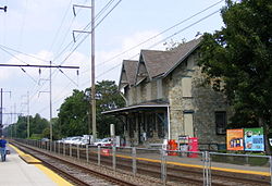
Station statistics Address Springfield Road & West Maryland Avenue
Clifton Heights, PA 19018Coordinates 39°55′35″N 75°17′27″W / 39.92634°N 75.29075°WCoordinates: 39°55′35″N 75°17′27″W / 39.92634°N 75.29075°W Lines Media/Elwyn LineConnections (Sharon Hill Trolley) Platforms 2 side platforms (Media/Elwyn)
Sidewalks(Route 102)Tracks 2 (Media/Elwyn), 2 (Route 102) Parking 110 Free/32 with Permits Other information Opened 1880 Electrified 1928 (Media/Elwyn) Owned by SEPTA Fare zone 2 Formerly Aldan Services Preceding station SEPTA Following station toward ElwynMedia/Elwyn Line toward Temple UniversityTransfer toward Sharon HillRoute 102 toward 69th StreetShisler Avenue(Closed March 15, 2010)toward Sharon HillClifton-Aldan is a station along the SEPTA Media/Elwyn Line. It is located at Springfield Road & Maryland Avenue and has a 110-space parking lot. This station is also within a walking distance of the Clifton-Aldan stop of the Route 102 Trolley (additional fare needed). The trolley stop is on the portion of the line where the tracks run in the streets rather than on their own right-of-way. Trolleys run beneath a narrow and low 13 feet 4 inches (4.06 m) bridge over Springfield Road with a parallel pedestrian tunnel before approaching the regional railroad station.[1] South of the station, the Route 102 line moves from Springfield Road to Woodlawn Avenue. A shelter for the northbound trolley exists on Woodlawn Avenue near the corner of Springfield Road.
History
According to the Pennsylvania Railroad Stations Past & Present website, Clifton-Aldan Station was originally built in 1880 by the Pennsylvania Railroad as Aldan Station, in the style of a stone Victorian farm house 21/2 stories high.[2] Parking is available on the south side of the tracks on the corner of Springfield Road and West Maryland Avenue as well as on the north side of the tracks along Jefferson Street between South Springfield Road and South Penn Street.
On May 28, 2009, SEPTA approved a $2.6 million dollar rehabilitation effort which will include Clifton-Aldan station.[3]
References
External links
Categories:- SEPTA stubs
- Pennsylvania railway station stubs
- SEPTA Regional Rail stations
- SEPTA Media–Sharon Hill Line stations
- Railway stations opened in 1880
- Stations along Philadelphia, Baltimore and Washington Railroad lines

Wikimedia Foundation. 2010.