- Clifton Campville
-
Coordinates: 52°41′46″N 1°37′30″W / 52.696°N 1.625°W
Clifton Campville 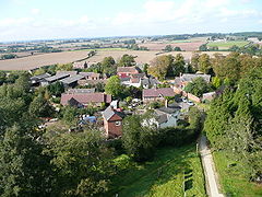
Clifton Campville from above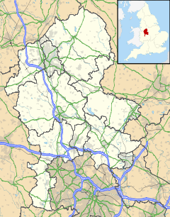
 Clifton Campville
Clifton Campville shown within StaffordshirePopulation 764 [1] OS grid reference SK255110 Parish Clifton Campville District Lichfield Shire county Staffordshire Region West Midlands Country England Sovereign state United Kingdom Post town TAMWORTH Postcode district B79 0 Dialling code 01827 Police Staffordshire Fire Staffordshire Ambulance West Midlands EU Parliament West Midlands UK Parliament Tamworth[2] List of places: UK • England • Staffordshire Clifton Campville is a village and civil parish[3] in Staffordshire, England. It lies on the River Mease, about 10 miles (16 km) east of the City of Lichfield, 6 miles (10 km) west of Measham and 7 miles (11 km) north of Tamworth. In 2001 the parish had a population of 764.
There is a fine gothic church, dedicated to St Andrew,[4] and listed Grade I. The village pub, The Green Man, is also a historic building.
Contents
History
The first part of the name is Old English clif tun, that is cliff farm; the family de Camvill held the land in the early 13th century.[5] The name has also been recorded as Clistone.[6]
There is some evidence of pre-Saxon, or even pre-historic settlement in the area. The settlement of Clistone is mentioned in Domesday Book as having 33 villagers, a priest, 11 ploughs and 2 mills. One of the mills was possibly at Mill Farm.[6]
After the Norman Conquest the manor belonged to the king. From 1200 it was owned by the Camville (or de Camvill) family, at least until 1315. By 1700 it was in possession of the Coventry family, who sold it in that year to Sir Charles Pye, Bart. His family still owned the manor in 1851, in the person of Henry John Pye.[7][8]
In 1848 the parish included both Haunton and Harlaston, and also Chilcote in Derbyshire. Clifton itself then had a population of 341, while the population of the whole parish was 921 on 6,300 acres (25 km2).[8] The core parish of Clifton and Haunton covered around 3,000 acres (12 km2) in 1851.[7] Nowadays the Church of England parish still includes Haunton and Chilcote, and also Statfold.[9]
Governance
The parish of Clifton Campville formerly included Chilcote in Derbyshire, and Harlaston, as well as Haunton, which it still does. It became part of Tamworth Poor Law Union in 1836; in 1866 Harlaston became a civil parish in its own right. In 1894 Clifton with Haunton became a civil parish within the newly-constituted Tamworth Rural District.[10][11]
The civil parish became part of Lichfield Rural District during the boundary changes of 1934. In 1974 it became part of the new non-metropolitan district of Lichfield. The parish council meets jointly with Thorpe Constantine.[11][12]
Electorally the parish is part of Mease and Tame ward of Lichfield District,[13] and lies within the parliamentary constituency of Tamworth.[2]
Landmarks
Clifton contains a number of listed buildings, including the Grade I listed Church of St Andrew, Clifton Hall, Manor Farm, the old Post Office and the village pub, the Green Man. There are also several historic buildings in Haunton.[14]
Church of St Andrew
 Church and monument at Clifton Campville
The parish church, dedicated to St Andrew, is a Grade I listed building.[14] Though nothing remains of the building mentioned in Domesday, some parts of the south wall date back to the year 1200, with traces of 13th century wall paintings. The church was enlarged into the shape of a cross in the first half of the 13th century. It was enlarged again in the 14th century. The tower was built in the first half of the 14th century, with a spire, reaching to a height of about 210 feet (65 m), added at some time during the century. The interior includes 14th century screens carved from oak; the rood screen is from the 15th century, as is some stained glass in one of the north windows. The church was restored by George Edmund Street in the second half of the 19th century, and again by W. D. Caroe in the early 20th century. In 1984 the spire was struck by lightning, with much damage to the church. Repairs were completed in 1987.[6][15]
The adjoining cemetery also dates back to mediaeval days.[6]
The Old Rectory is in origin a 15th century building, though the history of the rectory can be traced further back, to the mid 14th century. The building was altered in 1694, and again in 1778, and restored in around 1980. It is listed Grade II.[6][14]
Education
The village school is St Andrew's Church of England Controlled Primary School. In 2009 it had 63 pupils, and was rated as Outstanding by OFSTED.[16][17]
Other settlements
Main article: HauntonThe neighbouring village of Haunton, one mile (about 1.5 km) to the west, has historically been, and remains, part of the parish of Clifton Campville.
References
- ^ "2001 Census: Parish headcounts". Office for National Statistics. 28 April 2004. http://neighbourhood.statistics.gov.uk/dissemination/LeadTableView.do?a=7&b=799438&c=clifton+campville&d=16&e=15&g=485413&i=1001x1003x1004&m=0&r=1&s=1255203260796&enc=1&dsFamilyId=779. Retrieved 30 September 2009.
- ^ a b "United Kingdom Parliament". http://www.parliament.uk/. Retrieved 18 September 2009.
- ^ "Names and codes for Administrative Geography". Office for National Statistics. 31 December 2008. http://www.ons.gov.uk/about-statistics/geography/products/geog-products-area/names-codes/administrative/index.html. Retrieved 15 September 2009.
- ^ "St. Andrew's Church, Clifton Campville". Mease Valley Churches. http://www.measevalley.org.uk/clifton.htm. Retrieved 3 October 2009.
- ^ "Key to English Place Names". Institute for Name-Studies. http://www.nottingham.ac.uk/english/ins/kepn/search.php. Retrieved 30 September 2009.
- ^ a b c d e "Historic Environment Record: Monument Summary Report - Clifton Campville". Staffordshire County Council. 6 February 2008. http://www.search.staffspasttrack.org.uk/content/files/163/152/661.pdf. Retrieved 9 November 2009.
- ^ a b "GENUKI: Clifton Campville". 25 May 2000. http://www.genuki.org.uk/big/eng/STS/CliftonCampville/index.html. Retrieved 3 October 2009.
- ^ a b Samuel Lewis, ed (1848). A Topographical Dictionary of England: Clifton-Campville (St. Andrew). Institute of Historical Research. pp. 635–639. http://www.british-history.ac.uk/report.aspx?compid=50884&strquery=clifton%20campville. Retrieved 9 November 2009.
- ^ "St Andrew, Clifton Campville". A Church near you. Church of England. http://www.achurchnearyou.com/clifton-campville-st-andrew/. Retrieved 9 November 2009.
- ^ "Chilcote". Online Gazetteer. Staffordshire County Council. 21 April 2009. http://www.staffordshire.gov.uk/leisure/archives/history/placeguide/SPGChilcote.htm. Retrieved 30 October 2009.
- ^ a b "Clifton Campville". Online Gazetteer. Staffordshire County Council. 21 April 2009. http://www.staffordshire.gov.uk/leisure/archives/history/placeguide/SPGCliftonCampville.htm. Retrieved 30 September 2009.
- ^ "Parish clerk contact details". Lichfield District Council. 2009. http://www.lichfielddc.gov.uk/site/scripts/documents_info.php?documentID=540. Retrieved 16 September 2009.
- ^ "Register of Electors 2007: Lichfield District". 13 April 2007. http://www.lichfielddc.gov.uk/downloads/POLLING_STATIONS_2007.doc. Retrieved 22 October 2009.
- ^ a b c "Listed buildings of Clifton Campville CP". Lichfield District Council. http://www.lichfielddc.gov.uk/downloads/CLIFTON_CAMPVILLE.pdf. Retrieved 1 October 2009.
- ^ "A History of St. Andrew's Church". Mease Valley Churches. http://www.measevalley.org.uk/clifton_history.htm. Retrieved 3 October 2009.
- ^ "Staffordshire School Directory". 2009. http://education.staffordshire.gov.uk/Directories/SchoolDirectory/Details.aspx?base=128&hiddenurl=%2FDirectories%2FSchoolDirectory%2FSearch.aspx%3FtxtName%3D%26txtArea%3D%26lstSchoolType%3DALL%26lstDistricts%3DLID%26recordCount%3D48%26pageId%3D3. Retrieved 9 November 2009.
- ^ "St. Andrew’s School website". http://www.staffordshire.schooljotter.com/andrews. Retrieved 9 November 2009.
External links
- Village website
- Images of England: Details of listed buildings
- Staffordshire Past Track: Old images of Clifton Campville
Lichfield District Council Lichfield District CouncilCivil parishes Alrewas • Armitage with Handsacre • Burntwood • Clifton Campville • Colton • Curborough and Elmhurst • Drayton Bassett • Edingale • Elford • Farewell and Chorley • Fazeley • Fisherwick • Fradley • Hammerwich • Hamstall Ridware • Harlaston • Hints • Kings Bromley • Lichfield • Longdon • Mavesyn Ridware • Shenstone • Streethay • Swinfen and Packington • Thorpe Constantine • Wall • Weeford • Whittington • Wigginton and HopwasCategories:- Lichfield
- Villages in Staffordshire
- Civil parishes in Staffordshire


Wikimedia Foundation. 2010.