- Sogn og Fjordane
-
Sogn og Fjordane fylke — County — 

Coat of armsSogn og Fjordane within Norway
Country Norway County Sogn og Fjordane Region Vestlandet County ID NO-14 Official language form Nynorsk Administrative centre Hermansverk Government – Governor Oddvar Flæte
(1994–present)– County mayor Nils R. Sandal
Senterpartiet
(2003–present)Area(#8 in Norway, 5.81% of Norway's land area) – Total 18,623 km2 (7,190.4 sq mi) – Land 17,709 km2 (6,837.5 sq mi) – Water 914 km2 (352.9 sq mi) Population (2010) – Total 109,100 – Density 5.9/km2 (15.2/sq mi) – Change (10 years) -0.5 % – Rank in Norway 17 (2.21% of country) Time zone CET (UTC+01) – Summer (DST) CEST (UTC+02) Income (per capita) 134,400 NOK GDP (per capita) 231,982 NOK (2001) National Rank: 16 (1.63% of country) Website www.sfj.no Data from Statistics Norway  Sogn og Fjordane (help·info) is a county in Norway, bordering Møre og Romsdal, Oppland, Buskerud, and Hordaland. The county administration is in the town of Hermansverk in Leikanger municipality while the largest town is Førde.
Although Sogn og Fjordane has some industry, predominantly hydroelectricity and aluminium, it is predominantly agricultural. Sogn og Fjordane is also home to the Urnes stave church and Nærøyfjord, which is listed by UNESCO as world heritage sites.
The Høgskulen i Sogn og Fjordane (Sogn og Fjordane University College) has campuses in Sogndal, Sandane, and Førde.
Contents
Name
The name Sogn og Fjordane was created in 1919. The first element is the name of the region Sogn. The last element is the plural definite form of fjord, which refers to the two regions in the county called Nordfjord and Sunnfjord.
Prior to 1919, the name of the county was Nordre Bergenhus amt which meant "(the) northern (part of) Bergenhus amt". (The old Bergenhus amt, created in 1662, was divided in 1763.)
See also: HordalandCoat of arms
The coat of arms were granted on 23 September 1983. The arms show the geographical layout of the county: three large fjords protruding into the land. The three fjords are the Nordfjord, Sunnfjord and Sognefjord. Nearly all villages and towns are situated on one of these fjords and the name of the county is based on the fjords.[1]
Districts
The county is conventionally divided into three traditional districts. These are Sogn (in the south), Sunnfjord (in the center), and Nordfjord (in the north). Sogn surrounds the Sognefjord from Solund on the offshore island of Sula in the North Sea to the village of Skjolden in Luster along the Lustrafjord, a branch of the Sognefjord. The total length is 204 kilometres (127 mi).
Language
Sogn og Fjordane is the only county in which all municipalities have declared Nynorsk to be their official written form of the Norwegian language.
History
The county currently consists of the two historic counties: Firdafylke (now the Fjordane region) and Sygnafylke (now the Sogn region). These both were formed in the Middle Ages under the Gulating government. They were merged with Hordafylke (now Hordaland) and Sunnmørafylke (now Sunnmøre) to form the Bergenhus len in the late Middle Ages. The Bergenhus len was one of four len in Norway. It was administered from the Bergenhus Fortress in Bergen.[2]
On 19 February 1662, a royal decree changed the name to Bergenhus amt. The Sunnmøre region was moved to Romsdal county in 1689. Later, in 1763, the amt was divided in half creating: Nordre Bergenhus and Søndre Bergenhus. Later, on 1 January 1919, Nordre Bergenhus amt was re-named Sogn og Fjordane fylke during a period of time when many location names were changed.[3]
Government
A county (fylke) is the chief local administrative area in Norway. The whole country is divided into 19 counties. A county is also an election area, with popular votes taking place every 4 years. In Sogn og Fjordane, 39 members are elected to form a county council (Fylkesting). Heading the Fylkesting is the county mayor (fylkesordførar). Since 2003, the Sogn og Fjordane county municipality has been led by Nils R. Sandal, the county mayor.[3]
The county also has a County Governor (fylkesmann) who is the representative of the King and Government of Norway. Oddvar Flæte has been the County Governor of Sogn og Fjordane since 1994.
The municipalities of Sogn og Fjordane are divided among three district courts (tingrett): Sogn, Fjordane, and Nordhordland. Sogn og Fjordane is also part of the Gulating Court of Appeal district based in Bergen.[2]
- Sogn District Court: Aurland, Balestrand, Leikanger, Luster, Lærdal, Sogndal, Vik, and Årdal
- Fjordane District Court: Askvoll, Bremanger, Eid, Fjaler, Flora, Førde, Gaular, Gloppen, Hornindal, Hyllestad, Høyanger, Jølster, Naustdal, Selje, Solund, Stryn, and Vågsøy
- Nordhordland District Court: Gulen (and the rest of the Nordhordland district of the county of Hordaland)
All of the municipalities of Sogn og Fjordane except Gulen and Solund are part of the Sogn og Fjordane police district. Gulen and Solund are part of the Hordaland police district.[2]
Geography
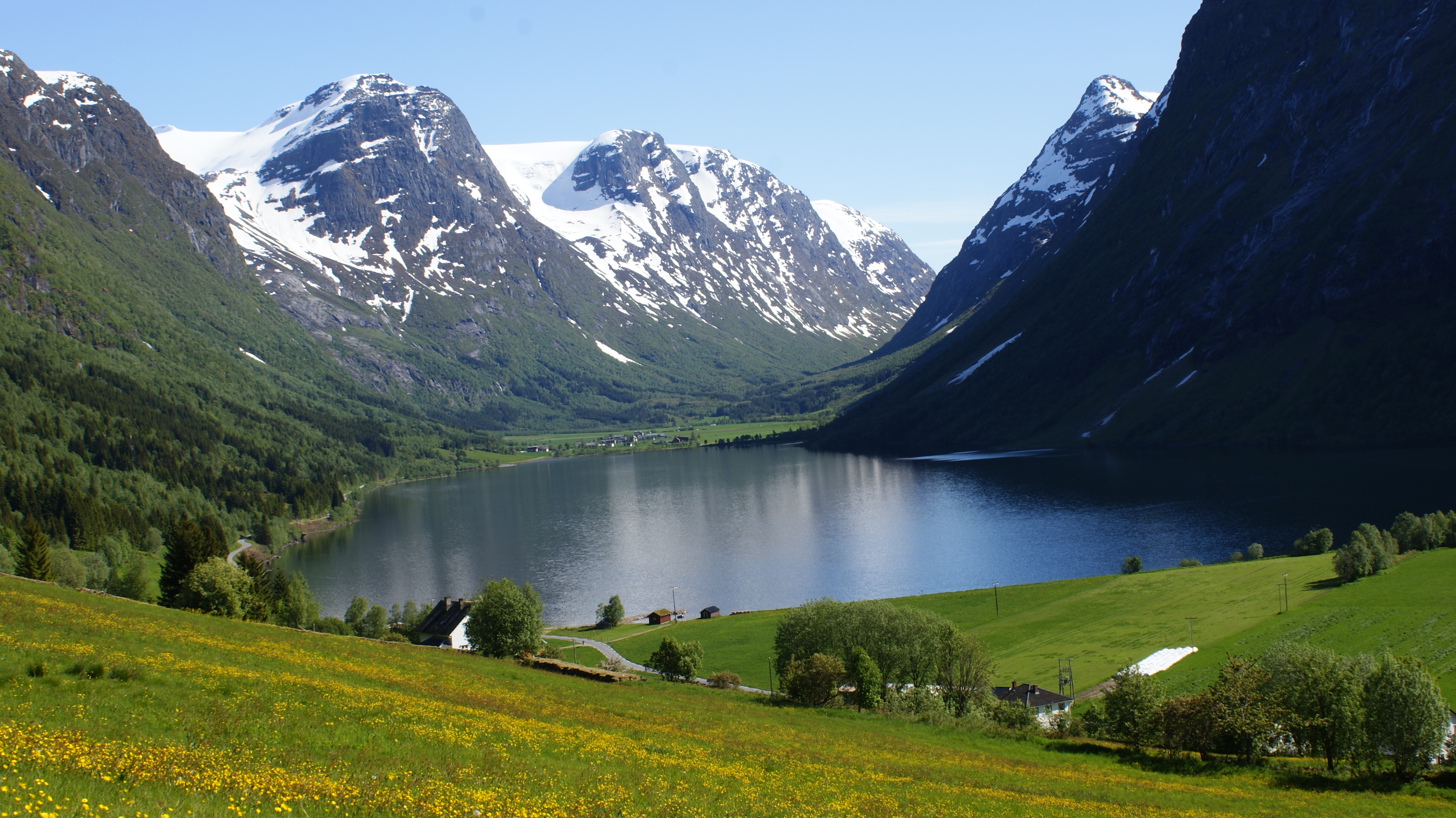
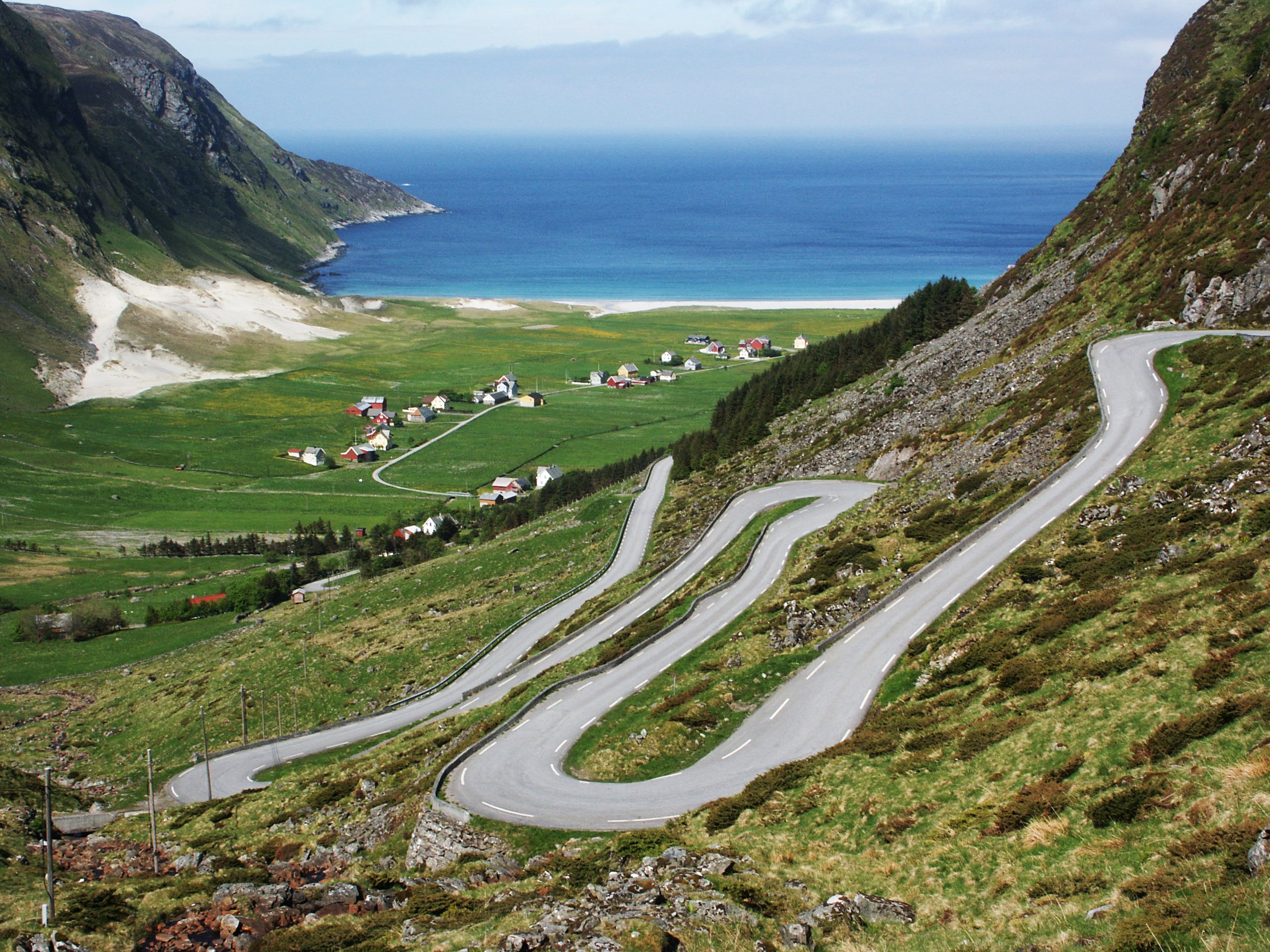
It is mainly a rural area with a scattered population. Sogn og Fjordane includes the largest glacier in mainland Norway, Jostedalsbreen, in the Breheimen mountain range, and the deepest lake, Hornindalsvatnet. There are also many famous waterfalls located in the area. Ramnefjellsfossen (previously called Utigardfossen) is the tallest in Norway and third tallest in the world and Vettisfossen is one of Norway's highest waterfalls with a vertical drop of 275 metres (902 ft). Both are located in the Jotunheim mountains. Cruise ships visit Sogn og Fjordane all summer because of the unique vistas of high mountains and deep blue fjords.
The famous Nærøyfjord is located in the south of the county. This is a UNESCO listed fjord area. There are several archipelagos, including Bulandet, Bremanger and islands around Florø. The westernmost point in Norway proper is Holmebåen in Solund municipality. The island of Unst, part of Shetland Islands is around 300 kilometres (190 mi) west of Holmebåen.
The terrain changes quite rapidly with mostly smaller mountains on the coastline, gradually increasing to mountains reaching more than 2,000 metres (6,600 ft). Because of the steep rise in elevation and fjords cutting through the terrain, the amount of precipitation is very high. Low pressure systems come in from the west and meet the mountains (a phenomenon known as orographic lifting) and cause rain and snowfall.
-

Myklebustdalen valley east of Byrkjelo
-

The village of Hoddevik on the Stad peninsula in Selje
-

Some old houses in Lærdalsøyri, Lærdal
-

View from Aurland
Municipalities
Historical populations Year Pop. ±% 1951 97,714 — 1961 99,957 +2.3% 1971 100,933 +1.0% 1981 105,924 +4.9% 1991 106,614 +0.7% 2001 107,590 +0.9% 2011 107,742 +0.1% 2021? 114,542 +6.3% 2031? 119,252 +4.1% Source: Statistics Norway[4][5] In 1837, the counties were divided into local administrative units, each with their own governments. The number and borders of these municipalities have changed over time, and at present there are 26 municipalities in Sogn og Fjordane.
Municipalities of Sogn og Fjordane Key 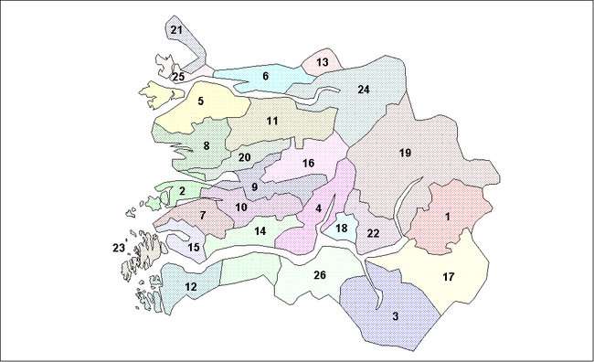
See also
References
- ^ "Sogn og Fjordane". Norske Kommunevåpen. http://www.ngw.nl/int/nor/sognfjord.htm. Retrieved 23 August 2008.
- ^ a b c "Sogn og Fjordane". Bokmål Wikipedia. http://no.wikipedia.org/wiki/Sogn_og_Fjordane. (Norwegian)
- ^ a b Natvik, Oddvar (29 August 2005). "Sogn og Fjordane". http://www.sf-f.kommune.no/sff/emigration3.nsf/enduser?readform. Retrieved 23 August 2008.
- ^ "Population statistics. Population changes in municipalities. 1951-2011". Statistics Norway. http://www.ssb.no/english/subjects/02/02/folkendrhist_en/tables/tab/14.html. Retrieved 2010-05-26.
- ^ Projected population - Statistics Norway
- ^ Statistics Norway - Church of Norway.
- ^ Statistics Norway - Members of religious and life stance communities outside the Church of Norway, by religion/life stance. County. 2006-2010
External links
- County web site (Norwegian)
- NRK County encyclopedia (Norwegian)
- Firda - Sogn og Fjordane's largest newspaper (Norwegian)
- forum.firda.no - Sogn og Fjordane's largest discussion group (Norwegian)
Municipalities of Sogn og Fjordane Nordfjord 
Sunnfjord Sogn Counties of Norway Akershus · Aust-Agder · Buskerud · Finnmark · Hedmark · Hordaland · Møre og Romsdal · Nordland · Nord-Trøndelag · Oppland · Oslo · Østfold · Rogaland · Sogn og Fjordane · Sør-Trøndelag · Telemark · Troms · Vest-Agder · Vestfold

Coordinates: 61°20′00″N 05°50′00″E / 61.3333333°N 5.8333333°E
Categories:


Wikimedia Foundation. 2010.