- Clock Face, St Helens
-
See also: Clock face
Coordinates: 53°24′56″N 2°42′35″W / 53.41554°N 2.7098°W
Clock Face 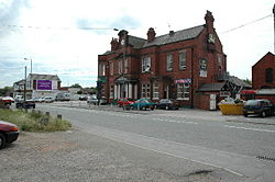
The Clock Face public house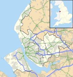
 Clock Face
Clock Face shown within MerseysideOS grid reference SJ529912 Metropolitan borough St Helens Metropolitan county Merseyside Region North West Country England Sovereign state United Kingdom Post town ST. HELENS Postcode district WA9 Dialling code 01744 Police Merseyside Fire Merseyside Ambulance North West EU Parliament North West England UK Parliament St Helens South and Whiston List of places: UK • England • Merseyside Clock Face is an area of St. Helens, Merseyside, England, 5.6 km (3.5 mi) south of the town centre, situated near Sutton Manor in the district of Sutton, and just north of the M62 motorway. Historically a part of Lancashire, Clock Face forms part of the parish of Bold. It is also a ward within the Metropolitan Borough of St Helens. It is so named because of the large clock face that once graced the area; this name was also taken by a colliery in the area. The Clock Face public house now maintains the area's name.
Contents
Industry
The area was an important coal mining village with three collieries in the vicinity, including the eponymous Clock Face Colliery (which was closed in 1966),[1] Sutton Manor Colliery (which was closed in 1991),[2] and Parkside Colliery, which was closed in 1992, following a lengthy NUM-linked sit-in protest,[3] as the last deep mine in the Lancashire Coalfield.[4]
Clock Face Country Park is situated on the site of one of the former collieries. In the late 1990s, the 57-acre (230,000 m2) site was reclaimed by St Helens Council as a public open space. It contains developing woodlands, meadow areas and a fishing pond leased to a local angling club. The former mineral railway route has been reclaimed as a pathway to Sutton Manor Woodlands.[5]
Transportation
Clock Face was once served by the St Helens and Runcorn Gap Railway at Clock Face station on Gartons Lane. The area is currently served by Lea Green railway station on the northern route of the Liverpool to Manchester Line. Arriva North West operate bus services in Clock Face, routes 32/32A/32C and 33/33A link the area to St Helens Hospital and the Town Centre as well as routes 121/122 (replacing 32A) in the evenings. Other bus companies serving the area include Merseytravel's 140 and 265 bus routes, Halton Transport's 17/17A/17B bus routes and Strawberry Bus' Line 1 bus route.
References
- ^ http://www.suttonbeauty.org.uk/clockfacecolliery.html
- ^ "The Lancashire Coalfields: Sutton Manor". Bernard Platt. http://homepage.ntlworld.com/bernard.platt/sutton%20manor%20-%20profile.htm. Retrieved 18 March 2008.
- ^ http://www.healeyhero.co.uk/rescue/Collection/ian/page_9.htm
- ^ http://www.jstor.org/pss/317503
- ^ "Clock Face Country Park". Sutton Beauty. http://www.suttonbeauty.org.uk/clockfacepark.html. Retrieved 18 March 2008.
External links
- Sutton Beauty – A photographic appreciation of the Sutton district of St Helens which includes the Clock Face Country Park and Sutton Manor (Colliery) Woodlands
Blackbrook · Bold · Carr Mill Dam · Clock Face · Eccleston · Moss Bank · Parr · Ravenhead · Sutton Leach & Sutton Manor · Thatto Heath · WindleCategories:- St Helens, Merseyside
- Towns and villages in St Helens, Merseyside
- Merseyside geography stubs


Wikimedia Foundation. 2010.