- Clover, Cabell County, West Virginia
-
Clover, West Virginia — Unincorporated community — 
 Clover, West Virginia
Coordinates: 38°35′00″N 82°13′40″W / 38.5833333°N 82.22778°WCoordinates: 38°35′00″N 82°13′40″W / 38.5833333°N 82.22778°W Country United States State West Virginia County Cabell Elevation 558 ft (170 m) Time zone Eastern (EST) (UTC-5) – Summer (DST) EDT (UTC-4) Area code(s) 304 & 681 GNIS feature ID 1549633[1] Clover is an unincorporated community in Cabell County, West Virginia, United States. Clover is located on West Virginia Route 2 near the Ohio River, 16 miles (26 km) northeast of Huntington.[2]
References
- ^ U.S. Geological Survey Geographic Names Information System: Clover, Cabell County, West Virginia
- ^ West Virginia Department of Transportation (2011). Cabell County, West Virginia General Highway Map (Map). p. 1. http://gis.wvdot.com/gti/County_Maps/Cabell_1_of_2.pdf. Retrieved October 12, 2011.
Municipalities and communities of Cabell County, West Virginia City 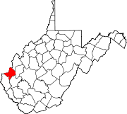
Town Village CDPs Other
communitiesFootnotes ‡This populated place also has portions in an adjacent county or counties
Categories:- Populated places in Cabell County, West Virginia
- Unincorporated communities in West Virginia
- Metro Valley geography stubs


Wikimedia Foundation. 2010.