- Nantucket
-
For other uses, see Nantucket (disambiguation).
Town & County of Nantucket, Massachusetts — Town — Nantucket

FlagLocation in Nantucket County in Massachusetts
Coordinates: 41°17′00″N 70°04′58″W / 41.2833333°N 70.08278°W Country United States State Massachusetts Settled 1641 Incorporated 1671 Government – Type Open town meeting Area – Total 105.3 sq mi (272.6 km2) – Land 47.8 sq mi (123.8 km2) – Water 57.5 sq mi (148.8 km2) Elevation 30 ft (9 m) Population (2010) – Total 10,172 – Density 212.8/sq mi (82.2/km2) Time zone Eastern (UTC-5) – Summer (DST) Eastern (UTC-4) ZIP code 02554 Area code(s) 508 / 774 Exchanges (508): 228, 325 FIPS code 25-43790 GNIS feature ID 0619376 Website www.nantucket-ma.gov Nantucket is an island 30 miles (48 km) south of Cape Cod, Massachusetts, in the United States. Together with the small islands of Tuckernuck and Muskeget, it constitutes the town of Nantucket, Massachusetts, and the coterminous Nantucket County, which are consolidated. Part of the town is designated the Nantucket CDP, or census designated place. The region of Surfside on Nantucket is the southernmost settlement in Massachusetts.
Canopache, meaning "place of peace", is the Wampanoag Native American name for the island.
Nantucket is a tourist destination and summer colony. The population of the island soars from about 10,000 to 50,000[1] during the summer months, due to tourists and summer residents. According to Forbes Magazine, in 2006, Nantucket had the highest median property value of any Massachusetts ZIP code.[2]
The Nantucket Historic District, comprising all of Nantucket Island, was added to the National Register of Historic Places on December 13, 1966. In doing so the National Park Service paid particular note to the settlements of Nantucket and Siasconset. The island features one of the highest concentrations of pre-Civil War structures in the United States. It also has the oldest operating windmill in the United States (since 1746). It was the setting for the hit NBC sitcom Wings (NBC TV series).
Contents
Origin of the name
Also nicknamed "The Grey Lady" due to the almost regular fog, Nantucket takes its name from a word in an Eastern Algonquian language of southern New England, originally spelled variously as natocke, nantaticut, nantican, and nautican. The meaning of the term is uncertain, although it may have meant "in the midst of waters," or "far away island."[3]
Other sources state the Native American word "Natockete," meaning "faraway land," to be Nantucket's namesake. The Wampanoag Native Americans who lived in Nantucket referred to the island as "Canopache," or "place of peace."
History
 1870s street scene on Nantucket.
Beginnings
The earliest English settlement in the region began on neighboring island Martha's Vineyard, named after Bartholomew's daughter Martha who died on board, en route. Nantucket Island's original inhabitants, the Wampanoag Indians, lived undisturbed until 1641 when the island was deeded by the English (the authorities in control of all land from the coast of Maine to New York) to Thomas Mayhew and his son, merchants of Watertown and Martha's Vineyard. The entire area of New York county had been purchased by Thomas Mayhew Sr. of Watertown, Massachusetts, in 1641, buying out competing land claims. Nantucket was part of Dukes County, New York until 1691, when it was transferred to the newly formed Province of Massachusetts Bay and split off to form Nantucket County. As Europeans began to settle Cape Cod, the island became a place of refuge for regional Indians, as Nantucket was not yet settled by Europeans. The growing population of Native Americans welcomed seasonal groups of Indians who traveled to the island to fish and later harvest whales that washed up on shore.
English settlement and the history of whaling in Nantucket
The history of Nantucket's settlement by the English did not begin in earnest until 1659, when Thomas Mayhew sold his interest to a group of investors, led by Tristram Coffin, "for the sum of thirty Pounds...and also two beaver hats, one for myself, and one for my wife". The "nine original porchasers" were Tristram Coffin, Peter Coffin, Thomas Macy, Christopher Hussey, Richard Swain, Thomas Barnard, Stephen Greenleafe, John Swain and William Pike. Seamen and tradesmen began to populate Nantucket, such as Richard Gardner (arrived 1667) and Capt John Gardner (arrived 1672), sons of Thomas Gardner (planter). [4]
Herman Melville comments on Nantucket's whaling dominance in Moby-Dick, Chapter 14: "Two thirds of this terraqueous globe are the Nantucketer's. For the sea is his; he owns it, as Emperors own empires." The Moby-Dick characters Ahab and Starbuck are both from Nantucket.
 Whale weathervane atop the Nantucket Historical Association Whaling Museum
In his 1835 history of Nantucket Island, Obed Macy wrote that in the early pre-1672 colony a whale of the kind called "scragg" entered the harbor and was pursued and killed by the settlers.[5] This event started the Nantucket whaling industry. A. B. Van Deinse points out that the "scrag whale", described by P. Dudley in 1725 as one of the species hunted by the early New England whalers, was almost certainly the Gray Whale which has flourished on the West Coast of North America with protection from whaling.[6][7]
By 1850, whaling was in decline, as Nantucket had been supplanted by New Bedford. The island suffered great economic hardships, worsened by the July 13, 1846 "Great Fire" that, fueled by whale oil and lumber, devastated the main town, burning some 40 acres.[8] It left hundreds homeless and poverty stricken, and many people left the island. Another contributor to the decline was the silting up of the harbor which prevented the large whaling ships from entering and leaving the port. In addition, the development of railroads made mainland whaling ports (such as New Bedford) more attractive because of the ease of transshipment of whale oil onto trains, an advantage unavailable to an island.
Later history
 From 1900 to 1918, Nantucket was the only place in the United States that successfully fought encroachment of the automobile. Clinton Folger was the mail carrier for Nantucket. Because cars were forbidden by the town, he towed his car to the state highway for driving to Siasconset.[9]
As a result of this depopulation, the island was left under-developed and isolated until the mid-20th century. The isolation kept many of the pre-Civil War buildings intact and by the 1950s, enterprising developers began buying up large sections of the island and restoring them to create an upmarket destination for the wealthy in the Northeastern United States. This highly controlled development can be compared to neighboring Martha's Vineyard, the development of which served as a model for what the Nantucket developers wanted to avoid.
In the 1960s Nantucket and Martha's Vineyard considered seceding from the Commonwealth of Massachusetts. In 1977, Nantucket and Martha's Vineyard actually attempted (unsuccessfully) to secede from the Commonwealth of Massachusetts. The secession vote was sparked by a proposed change to the Massachusetts Constitution, which reduced the islands' representation in the Massachusetts General Court.[10]
Geology and geography
Nantucket was formed by the uttermost reach of the Laurentide Ice Sheet during the recent Wisconsin Glaciation, shaped by the subsequent rise in sea level. The island's low ridge across the northern section was deposited as glacial moraine during a period of glacial standstill, a period during which till continued to arrive, but melted at a stationary front. The southern part of the island is an outwash plain, sloping away from the arc of moraine and shaped at its margins by the sorting actions and transport of longshore drift. Nantucket became an island when rising sea levels reflooded Buzzards Bay about 5,000–6,000 years ago.[11]
According to the U.S. Census Bureau, Nantucket County has a total area of 303.5 square miles (786 km2), the smallest county in Massachusetts, 84.25% of which is water. The area of Nantucket Island proper is 47.8 square miles (124 km2). The triangular region of ocean between Nantucket, Martha's Vineyard, and Cape Cod, is Nantucket Sound. The highest point on the island is Folger Hill which stands 109 feet (33 m) above sea level. Altar Rock is a close second at a height of 108 feet (33 m) above sea level.
 NASA satellite Image of Nantucket Island
The entire island, as well as the adjoining islands of Tuckernuck and Muskeget, comprise both the Town of Nantucket and the County of Nantucket. The main settlement, also called Nantucket, is located at the western end of Nantucket Harbor, where it opens into Nantucket Sound. Key localities on the island include Madaket, Surfside, Polpis, Wauwinet, Massachusetts, Miacomet and Siasconset (often abbreviated as 'Sconset).
Coatue
Coatue is a long barrier beach on Nantucket Island, separating Nantucket Sound from Nantucket Harbor. It has six points: First Point is situated due north of the village of Shimmo's Pimneys Point. Second Point, is north-northeast of the village of Shawkemo. Third Point is salt marsh. Fourth Point is due north of the Pocomo Peninsula, which contains the villages of Pocomo and West Wauwinet. The gap between Coatue and Pocomo is called the Wauwinet Straits. This deep and swift waterway has currents that reach 5 knots (9.3 km/h). Bass Point is the first point totally within Wauwinet Harbor. Wyers Point, the last point of land on Coatue, Wyers is connected to Coskata. At the head of Coatue is Coskata Pond.
Hummock Pond
Hummock Pond is a large pond on the south shore of Nantucket Island. It was created in the last ice age by the ice melt and used to be much larger, but during the blizzard of 1978 large swells from the Atlantic closed off the smaller western half, known as Clark's Cove. The pond is narrow and one of the deepest on Nantucket, and north head of the pond is connected by a small river. The north head is an extremely deep kettle hole with steep sides. The pond offers many kayaking opportunities, but is prone to strong south to southwesterly breezes.
Miacomet Pond
Miacomet Pond Location Nantucket, Massachusetts Coordinates 41°17′00″N 70°04′58″W / 41.2833333°N 70.08278°WCoordinates: 41°17′00″N 70°04′58″W / 41.2833333°N 70.08278°W Basin countries United States Max. depth 20 ft (6.1 m) Miacomet Pond is a narrow, slender pond on the south shore of Nantucket Island. The pond was once a river, but the oceans rose to make Nantucket an island in the last ice age. On average the pond is approximately 100 yards (91 m) wide, thus giving the appearance of a river. The northern head of the pond is only ten feet wide and was once connected to Nantucket Harbor via Newtown Creek. The maximum depth of the pond is twenty eight feet. The southern end of the pond is a sandy beach. Occasionally the pond is opened up to the sea.
Popsquatchet Hills
The Popsquatchet Hills are a range of peaks on Nantucket Island. Seldom reaching 100 feet (30 m), they can be considered the divide of Nantucket. Prospect Hill, the westernmost, is the location of the town's municipal cemetery. Chicken Hill is the next hill to the northeast. On the eastern side of Chicken Hill, there is a very deep valley known as Dead Horse Valley. On the north face of the hill, is Colt Valley.
Mill Hill, the hill nearest Hospital Valley, has the Old Mill sitting on its summit. Roads are frequent in the hills. Prospect Street, the main thoroughfare on the west end of town, is the northern side of the hills. Vesper Lane, is the southern boundary. Milk Street, is the northern boundary of the range. There are several smaller roads leading into the hills, but some of them have grown over.
In the winter time, Dead Horse Valley is the island's best sledding area. Chicken Hill was named for an old chicken farm maintained by William G. Egan.
Squam Swamp
Squam Swamp, a large swamp in the northeastern portion of the island of Nantucket, is located between Wauwinet Road, Squam Road, and Quidnet Road, just northwest of Quidnet and northeast of Polpis Harbor.[12]
Demographics
Historical populations Year Pop. ±% 1850 8,452 — 1860 6,094 −27.9% 1870 4,123 −32.3% 1880 3,727 −9.6% 1890 3,268 −12.3% 1900 3,006 −8.0% 1910 2,962 −1.5% 1920 2,797 −5.6% 1930 3,678 +31.5% 1940 3,401 −7.5% 1950 3,484 +2.4% 1960 3,559 +2.2% 1970 3,774 +6.0% 1980 5,087 +34.8% 1990 6,012 +18.2% 2000 9,520 +58.3% 2001* 9,742 +2.3% 2002* 10,076 +3.4% 2003* 10,305 +2.3% 2004* 10,536 +2.2% 2005* 10,608 +0.7% 2006* 10,803 +1.8% 2007* 11,060 +2.4% 2008* 11,272 +1.9% 2009* 11,322 +0.4% 2010 10,172 −10.2% * = population estimate.
Source: United States Census records and Population Estimates Program data.[13][14][15][16][17][18][19][20][21][22] The cobblestone Main Street in historic Downtown Nantucket
- There is also a census-designated place called Nantucket, with a 2000 population of 3,830, which is located within the Town of Nantucket.
At the census[23] of 2000, there were 9,520 people, 3,699 households, and 2,104 families residing in Nantucket. The population density was 199.1 people per square mile (76.9/km2). There were 9,210 housing units at an average density of 192.6 per square mile (74.4/km2). The racial makeup of the town was 87.85% White, 8.29% Black, 0.64% Asian, 0.04% Pacific Islander, 0.01% Native American, 1.60% from other races, and 1.58% from two or more races. Hispanic or Latino of any race were 2.23% of the population. 19.9% were of Irish, 17.1% English, 7.2% Italian, 6.1% Portuguese, 6.0% German and 5.1% French ancestry according to Census 2000. 92.6% spoke English, 4.1% Spanish and 1.6% French as their first language.
There were 3,699 households out of which 26.9% had children under the age of 18 living with them, 45.7% were married couples living together, 8.0% had a female householder with no husband present, and 43.1% were non-families. 29.8% of all households were made up of individuals and 8.0% had someone living alone who was 65 years of age or older. The average household size was 2.37 and the average family size was 2.90.
In the town the population was spread out with 19.2% under the age of 18, 7.4% from 18 to 24, 40.4% from 25 to 44, 22.5% from 45 to 64, and 10.5% at 65 years of age or older. The median age was 37 years. For every 100 females there were 105.3 males. For every 100 females age 18 and over, there were 105.0 males.
The median income for a household for year-round residents in the town is $55,522, and the median income for a family was $66,786. Males had a median income of $41,116 versus $31,608 for females. The per capita income for the town was $31,314. About 3.0% of families and 7.5% of the population were below the poverty line, including 2.3% of those under age 18 and 7.1% of those age 65 or over.
Government

Local:
- Town and county governments have been combined in Nantucket per List of counties in Massachusetts.
- Members of the town Board of Selectmen, who are also County Commissioners, with the year their term expires, are:[24]
- Rick Atherton (2011)
- Brian Chadwick (2011)
- Michael Kopko (2012)
- Whitey Willauer (2013)
- Patricia Roggeveen (2013)
State:
- Massachusetts House of Representatives:
- Timothy Madden, Democrat, of Nantucket represents Precincts 1, 2, 5, and 6, of Falmouth, in Barnstable County; and Chilmark, Edgartown, Aquinnah, Gosnold, Oak Bluffs, Tisbury and West Tisbury, all in Dukes County; and Nantucket.
- Massachusetts Senate
National:
- Nantucket is in the Massachusetts's 10th congressional district which has existed since 1795. It is currently represented in the United States House of Representatives by Bill Keating, a Democrat.
- Massachusetts is currently represented in the United States Senate by senior senator John Kerry (Democrat) and junior senator Scott Brown (Republican).
Presidential elections results Year Republican Democratic 2008 30.8% 1,863 67.3% 4,073 2004 35.6% 2,040 63.0% 3,608 2000 33.0% 1,624 58.3% 2,874 1996 29.4% 1,222 59.0% 2,453 1992 27.5% 1,158 48.3% 2,037 1988 39.4% 1,469 59.2% 2,209 1984 53.5% 1,697 45.9% 1,456 1980 40.5% 1,149 36.6% 1,040 1976 53.3% 1,399 42.5% 1,115 1972 59.6% 1,418 40.0% 952 1968 55.3% 991 41.5% 744 1964 32.8% 587 67.0% 1,197 1960 63.5% 1,219 36.4% 698 Voter Registration and Party Enrollment as of October 13, 2010[25] Party Number of Voters Percentage Democratic 2,283 28.79% Republican 1,251 15.77% Unaffiliated 4,351 54.86% Minor Parties 46 0.58% Total 7,931 100% Education
Nantucket is served by Nantucket Public Schools. The Nantucket school system has approximately 1,200 students, about 400 of whom attend the high school.
Schools include:
- Lighthouse School (Not Public)
- Nantucket New School (Not Public)
- Nantucket Elementary School (Public)
- Cyrus Peirce Middle School (Public)
- Nantucket High School
- Nantucket Community School (Public, Extracurricular)
See more from Nantucket Public Schools[26] from Plum TV on Nantucket.
A major museum association, the Maria Mitchell Association, offers educational programs to the Nantucket Public Schools.
Arts and culture
 Theodore Robinson's painting Nantucket, 1882
The island is well known as a center for both visual and performing arts.
Nantucket has several world-class museums, including the Maria Mitchell Association and the Whaling Museum.
Nantucket has a high concentration of artists and galleries, and have created an ongoing art colony since at least the 1920s. They have come over the decades to capture on canvas and in other media the natural beauty of the landscape, the seascapes, the flora and the fauna. On Friday evenings during the summer season, many of its galleries have open houses and special exhibits. Notable artists who have lived on, or painted in, Nantucket include Frank Swift Chase and Theodore Robinson.
Numerous authors followed the influx of specialists in the visual arts. Well-known writers who are or were residents of Nantucket include Herman Melville.
Music and theater are well-represented in Nantucket as well.
Transportation
Nantucket is served by Nantucket Memorial Airport, a three-runway airport on the south side of the island. The airport, whose three call letters are ACK, is one of the busiest in the Commonwealth and often logs more take-offs and landings on a summer day than Boston's Logan airport. This is due in part to the large number of private/corporate planes used by wealthy summer inhabitants, and in part to the 10-seat Cessna 402s used by several commercial air carriers to serve the island community. The airport is currently[when?] undergoing an expansion.[citation needed]
Nantucket Regional Transit Authority (NRTA) operates seasonal island-wide shuttle buses to many destinations including Surfside Beach, Sconset, and the airport.
Nantucket can be reached by sea from the mainland by using one of three commercial ferry services or by private boat.[27]
Historically, Nantucket was served by the narrow-gauge Nantucket Railroad. There are no traffic lights on the Island of Nantucket (except for the one in the car wash), and cars were not permitted on the Island until 1918.[citation needed]
Disasters
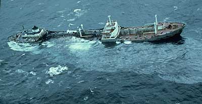
 The Argo Merchant ran aground on December 15, 1976. A silvery oil slick can be seen coming from the center holds.
Major disasters on or near Nantucket, include:
- On July 25, 1956, 51 people were killed in the collision of the Italian ocean liner SS Andrea Doria with the MS Stockholm in heavy fog 45 miles (72 km) south of Nantucket.
- On December 15, 1976, the oil tanker Argo Merchant ran aground southeast of Nantucket. Six days later, on December 21, the shipwreck broke apart, causing one of the largest oil spills in history.
- On October 31, 1999, EgyptAir Flight 990, traveling from New York City to Cairo, crashed off the coast of Nantucket, killing all 217 on board.
National Register of Historic Places
 Brant Point Light in Nantucket Harbor
The following Nantucket places are listed on the National Register of Historic Places;[28]:
- Brant Point Light Station — Brant Point (added October 28, 1987)
- Jethro Coffin House — Sunset Hill Road (added December 24, 1968)
- Nantucket Historic District (added December 13, 1966)
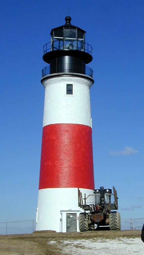
- Nantucket Light (added 1982 - Structure #82005272) Also known as Great Point Light; Located at Sandy Point, Nantucket Island, Nantucket. Built in 1784, the original wooden tower was destroyed by fire in 1816. The following year, 1817, a stone tower was erected which stood until toppled in a storm in March, 1984. This second tower was what was listed on the National Register. In 1986, a new stone tower was built to replicate the old one. This third tower remains in operation today.
- Sankaty Head Light — Sankaty Head (added November 15, 1987)
Notable residents
-
This list is incomplete; you can help by expanding it.
- The man from Nantucket, a legendary figure in limericks.
- Fred Rogers, AKA Mr. Rogers. American educator, Presbyterian minister, songwriter, and television host, had a summer home on the island.
17th, 18th & 19th centuries
- Abiah Folger, Benjamin Franklin's mother, was born on Nantucket. Her birthsite is marked by a plaque and is known to locals as "The Bench." In 2002 Nantucket High School seniors staged a celebration of her birth at the site—a tradition which has continued every year since.
- Absalom Boston, the first African American to serve as captain of a whaling ship with an all-black crew.
- John B. Macy, U.S. Representative from Wisconsin, was among the victims who died aboard the palace steamer Niagara.
- Rowland Hussey Macy, founder of Macy's, was born on the island and learned the retail business in a small shop on Main Street (which is marked by a plaque).
- Lucretia Coffin Mott was born in 1793 on Nantucket. Mott was an American Quaker minister, abolitionist, social reformer, and proponent of women's rights. She is credited as the first American "feminist" in the early 19th century but was, more accurately, the initiator of women's political advocacy.
- Maria Mitchell, native of Nantucket, first American female professional astronomer and a Vassar professor (of astronomy) is buried in Prospect Hill.
- Cyrus Peirce, first principal of Nantucket High School and later first president of what is now Framingham State College, married Nantucket native, Harriet Coffin. They are both buried in Prospect Hill Cemetery. Cyrus Peirce Middle School is named for him.
- Joseph Gardner Swift, a Nantucket native, was the first graduate of the United States Military Academy; he attained the rank of Brigadier General.
- Tristram Coffin, born in Plymouth, England around 1610, married Dionis Stevens (for whom Dionis beach is named). He is among the group who purchased the island from the Wampanoag Indians in 1659, for the sum of thirty pounds and a pair of beaver-skin hats. In 1671, Coffin was appointed Chief Magistrate of Nantucket. His stately brick mansion still stands on Upper Main Street, and many of his descendants still live on the island.
20th & 21st centuries
 Nantucket Range Lights at Brant Point
- Russell Baker, former New York Times columnist, had a summer home on the island.
- Bill Belichick, Head coach of the New England Patriots, owns several homes in 'Sconset.
- Peter Benchley, Author of Jaws, Beast and other novels, lived on the island.
- A. J. Cronin, novelist, resided on the island.
- Bill Frist, physician, author and former Republican Tennessee Senator has a home on the Island.
- Charles Geschke, co-founder of Adobe Systems
- Frank and Kathie Lee Gifford have a house on the island.
- Robert Greenhill, the investment banker, has a home on the island.
- David Halberstam, Pulitzer Prize winning journalist and historian, had a summer home on the island.
- James H. Cromartie, internationally renowned hard-edge realist and historical artist who resides year-round on the island.
- Kerry Hallam, artist of international reputation who released Nantucket Notables, a collection of watercolor sketches of Nantucket's residents, lives in a cottage off Bartlett Road.[29]
- Dorothy Hamill, American figure skater, has a home on the island.
- Teresa Heinz and John Kerry own a summer residence on Brant Point.
- Tommy Hilfiger, retail giant of the eponymous clothing label, owns a summer home on the island. The country house was featured in the MTV reality show Rich Girls, which starred his daughter Ally.
- Judith Ivey, actress, has a home in the village of Siasconset
- Seward Johnson, sculptor, has a summer residence on Brant Point.
- Frances Karttunen, academic linguist, historian and Mesoamericanist scholar, grew up and resides on the island
- Frank Lorenzo, former aviation executive, has a home on the north shore of the island.
- Chris Matthews, NBC correspondent, has a home on the island.
- Richard Mellon Scaife, billionaire businessman, owns a summer residence near Wauwinet.
- Nathaniel Philbrick, best selling author of In the Heart of the Sea: The Tragedy of the Whaleship Essex and The Mayflower.
- Fred Rogers, Mr. Rogers of Mr. Rogers' Neighborhood (PBS television), lived in Madaket.[30]
- Ned Rorem, Pulitzer Prize winning composer of classical music, owns a home on the island.
- David M. Rubenstein, billionaire co-founder of the Carlyle Group, spends summers at Abrams Point.
- Tim Russert, NBC correspondent, owned a home on the island.
- Richard Mellon Scaife, billionaire publisher who underwrote investigations into President Bill Clinton, has a home on Nantucket.
- Eric Schmidt, CEO of Google, and wife Wendy have a home on Cliff Road.
- John Shea, actor, has a home on the village of Siasconset
- Frank Stallone, actor/musician, is currently building a multi-million dollar estate in Surfside.
- Barry Sternlicht, founder of Starwood Capital Group, has a home near Eel Point.
- Jerry Stiller and Anne Meara have a home at Children's Beach.
- Louis Susman, U.S. Ambassador to the United Kingdom, has a home on the north shore of the island.
- Bruce Taylor, founder of Xcaliber International, one of the largest tobacco manufacturers in the U.S. owns a home on Polpis Road.
- Jack Welch, retired General Electric CEO, has an estate on the east side of the island near 'Sconset.
- Bob Wright, chairman of NBC Universal, and Suzanne Wright are founders of 'Autism Speaks' and have a home on Medouie Creek.
See also
- Narrative Of Arthur Gordon Pym
- There once was a man from Nantucket
- Brant Point Light
- Folgers Coffee
- List of Registered Historic Places in Nantucket County, Massachusetts
- Nantucket (CDP), Massachusetts
- Nantucket Independent (other weekly newspaper)
- Nantucket Reds
- Nantucket Sound
- Martha's Vineyard
- Maria Mitchell
- Moby-Dick
- Mary Morrill
- Mayhew Folger
- Lucretia Mott
- Rowland Hussey Macy
- The Inquirer and Mirror (main weekly newspaper)
- Wampanoag people
- Charles F. Winslow
- Nantucket Sleighride
- Nantucket shipbuilding
- Nantucket Forests
- Nantucket Dreamland Foundation
- Nantucket Nectars
Notes
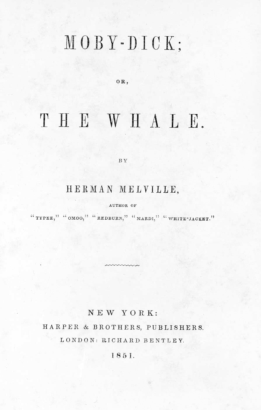
 Title page of the first U.S. edition of Moby-Dick, 1851.
- Bond, C. Lawrence, Native Names of New England Towns and Villages, privately published by C. Lawrence Bond, Topsfield, Massachusetts, 1991.
- Philbrick, Nathaniel, In The Heart of the Sea: The Tragedy of the Whaleship Essex, Penguin, NY, NY, 2000.
Further reading
- Macy, William Francis (1915). The story of old Nantucket; a brief history of the island and its people from its discovery down to the present day. Nantucket: The Inquirer and mirror press. http://books.google.com/?id=xCcSAAAAYAAJ&printsec=frontcover.
- Tower, W.S. (1907). A History of the American Whale Fishery. University of Philadelphia. http://books.google.com/?id=du4JAAAAIAAJ&printsec=frontcover.
References
- ^ http://www.fsbosellbuy.com/massachusetts/nantucket/nantucket/
- ^ http://www.newsmax.com/insidecover/biden_nantucket_holiday/2008/11/27/155858.html
- ^ Huden, John C. (1962). Indian Place Names of New England. New York: Museum of the American Indian. Cited in: Bright, William (2004). Native American Place Names in the United States. Norman: University of Oklahoma Press, pg. 312
- ^ Gardner, Frank A MD (1907). Thomas Gardner Planter and Some of his Descendants. Salem, MA: Essex Institute. (via Google Books)
- ^ Macy O (1835). The History of Nantucket:being a compendious account of the first settlement of the island by the English:together with the rise and progress of the whale fishery, and other historical facts relative to said island and its inhabitants:in two parts. Boston: Hilliard, Gray & Co.. ISBN 1437402232.
- ^ Van Deinse, AB (1937). "Recent and older finds of the gray whale in the Atlantic". Temminckia 2: 161–188.
- ^ Dudley, P (1725). "An essay upon the natural history of whales". Philosophical Transactions of the Royal Society of London 33: 256–259.
- ^ Kelley, Shawnie (2006). It Happened on Cape Cod. Globe Pequot. ISBN 978-0762738243. http://books.google.com/books?id=EuSeEVcASI4C. Retrieved 2011-11-22.
- ^ Nantucket Historical Association
- ^ People Section Time Magazine, April 18, 1977.]
- ^ The most recent survey of the geology of Cape Cod and the islands, accessible to the layman, is Robert N. Oldale, Cape Cod, Martha's Vineyard & Nantucket: The Geologic Story, 2001.
- ^ Squam Swamp Interview on Nantucket Plum TV.
- ^ "TOTAL POPULATION (P1), 2010 Census Summary File 1, All County Subdivisions within Massachusetts". United States Census Bureau. http://factfinder2.census.gov/bkmk/table/1.0/en/DEC/10_SF1/P1/0400000US25.06000. Retrieved September 13, 2011.
- ^ "Massachusetts by Place and County Subdivision - GCT-T1. Population Estimates". United States Census Bureau. http://factfinder.census.gov/servlet/GCTTable?_bm=y&-geo_id=04000US25&-_box_head_nbr=GCT-T1&-ds_name=PEP_2009_EST&-_lang=en&-format=ST-9&-_sse=on. Retrieved July 12, 2011.
- ^ "1990 Census of Population, General Population Characteristics: Massachusetts". US Census Bureau. December 1990. Table 76: General Characteristics of Persons, Households, and Families: 1990. 1990 CP-1-23. http://www.census.gov/prod/cen1990/cp1/cp-1-23.pdf. Retrieved July 12, 2011.
- ^ "1980 Census of the Population, Number of Inhabitants: Massachusetts". US Census Bureau. December 1981. Table 4. Populations of County Subdivisions: 1960 to 1980. PC80-1-A23. http://www2.census.gov/prod2/decennial/documents/1980a_maABC-01.pdf. Retrieved July 12, 2011.
- ^ "1950 Census of Population". Bureau of the Census. 1952. Section 6, Pages 21-10 and 21-11, Massachusetts Table 6. Population of Counties by Minor Civil Divisions: 1930 to 1950. http://www2.census.gov/prod2/decennial/documents/23761117v1ch06.pdf. Retrieved July 12, 2011.
- ^ "1920 Census of Population". Bureau of the Census. Number of Inhabitants, by Counties and Minor Civil Divisions. Pages 21-5 through 21-7. Massachusetts Table 2. Population of Counties by Minor Civil Divisions: 1920, 1910, and 1920. http://www2.census.gov/prod2/decennial/documents/41084506no553ch2.pdf. Retrieved July 12, 2011.
- ^ "1890 Census of the Population". Department of the Interior, Census Office. Pages 179 through 182. Massachusetts Table 5. Population of States and Territories by Minor Civil Divisions: 1880 and 1890. http://www2.census.gov/prod2/decennial/documents/41084506no553ch2.pdf. Retrieved July 12, 2011.
- ^ "1870 Census of the Population". Department of the Interior, Census Office. 1872. Pages 217 through 220. Table IX. Population of Minor Civil Divisions, &c. Massachusetts. http://www2.census.gov/prod2/decennial/documents/1870e-05.pdf. Retrieved July 12, 2011.
- ^ "1860 Census". Department of the Interior, Census Office. 1864. Pages 220 through 226. State of Massachusetts Table No. 3. Populations of Cities, Towns, &c.. http://www2.census.gov/prod2/decennial/documents/1860a-08.pdf. Retrieved July 12, 2011.
- ^ "1850 Census". Department of the Interior, Census Office. 1854. Pages 338 through 393. Populations of Cities, Towns, &c.. http://www2.census.gov/prod2/decennial/documents/1850c-11.pdf. Retrieved July 12, 2011.
- ^ "American FactFinder". United States Census Bureau. http://factfinder.census.gov. Retrieved 2008-01-31.
- ^ Nantucket, MA
- ^ "Registration and Party Enrollment Statistics as of October 13, 2010" (PDF). Massachusetts Elections Division. http://www.sec.state.ma.us/ele/ele10/enrollment_count_regdt_10132010.pdf. Retrieved 2010-03-14.
- ^ http://nantucket.plumtv.com/archives/topic/401
- ^ Getting to Nantucket Island
- ^ National Register of Historical Places - MASSACHUSETTS (MA), Nantucket County
- ^ http://www.nantucketindependent.com/news/2007/0815/The_Arts/030.html
- ^ http://www.nantucketindependent.com/news/2007/0801/front_page/013.html
External links
- Nantucket Historical Association
- "Nantucket.net", the island's ISP and portal site
- "Nantucket Directory", searchable island telephone & internet directory
- Nantucket Visitor's Guide, Nantucket Visitor's Guide
- Town and County of Nantucket official site
- Nantucket travel guide from Wikitravel
- Nantucket Island Chamber of Commerce
- The Nantucket Independent, the weekly newspaper
- Nantucket Inquirer and Mirror, the local newspaper
- Fabrikant, Geraldine, "Old Nantucket Warily Meets the New", New York Times, June 5, 2005
- Yesterday's Island, a local magazine
- Listing for Nantucket County and for the Nantucket Historic District, in the National Register of Historic Places
- Nantucket County, Massachusetts Genealogy and History
- Map of cities and towns of Massachusetts
- Nantucket Historical Assoc. on Flickr
- 36 Hours in Natucket in the New York Times of July 18, 2010
- I Once Had a Chum from Nantucket by Drs. Ernest and Convalescence Bidet-Wellville on Neatorama
Municipalities and communities of Nantucket County, Massachusetts Town 
CDP Other
villagesCategories:- Cape Cod and the Islands
- Nantucket, Massachusetts
- County seats in Massachusetts
- Massachusetts counties
- Populated coastal places in Massachusetts
- Islands of Massachusetts
- Populated places established in 1641
- Port settlements in the United States
- Landforms of Nantucket County, Massachusetts


Wikimedia Foundation. 2010.