- Unorganized South West Cochrane District
-
Unorganized Cochrane South West Part — Unorganized territory — 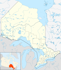
 Unorganized Cochrane South West Part
Coordinates: 48°22′N 80°36′W / 48.367°N 80.6°W Country  Canada
Province  Ontario
District Cochrane Government - Federal riding Timmins—James Bay - Prov. riding Timmins—James Bay Area[1] - Land 553.37 km2 (213.7 sq mi) Population (2006)[1] - Total 0 - Density 0/km2 (0/sq mi) Time zone EST (UTC-5) - Summer (DST) EDT (UTC-4) Postal Code Area code(s) 705 Unorganized Cochrane South West Part is an unorganized area in the Canadian province of Ontario, encompassing the small portion of the Cochrane District, between Black River-Matheson and Timmins, which is not part of either municipality.[2]
The division had a population of zero in the Canada 2006 Census, and a land area of 553.37 square kilometres.[1]
Demographics
Population:[3]
- Population in 2006: 0
- Population in 2001: 0
- Population in 1996: 2
- Population in 1991: 0
References
- ^ a b c Statistics Canada 2006 Census - Cochrane, Unorganized, South West Part community profile
- ^ GeoSearch 2006
- ^ Statistics Canada: 1996, 2001, 2006 census

Black River-Matheson Timmins 
Black River-Matheson  Unorg. South West Cochrane

Unorganized West Timiskaming Dist. City 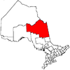
Towns Townships First Nations reserves Abitibi 70 • Constance Lake 92 • Factory Island 1 • Flying Post 73 • Fort Albany 67 • Moose Factory 68 • New Post 69 • New Post 69AUnorganized territories North Part • South East Part • South West PartSee also: Communities in Cochrane District • Census divisions of Ontario Categories:- Unorganized areas in Ontario
- Cochrane District, Ontario
- Northern Ontario geography stubs


Wikimedia Foundation. 2010.