- Cocking, West Sussex
-
Coordinates: 50°57′05″N 0°45′03″W / 50.9513°N 0.75095°W
Cocking 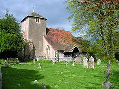
Church of St. Catherine of Siena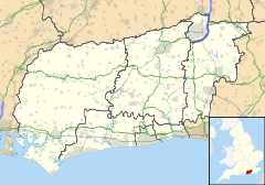
 Cocking
Cocking shown within West SussexArea 10.16 km2 (3.92 sq mi) [1] Population 459 [1] 2001 Census - Density 45 /km2 (120 /sq mi) OS grid reference SU878176 - London 47 miles (76 km) NE Parish Cocking District Chichester Shire county West Sussex Region South East Country England Sovereign state United Kingdom Post town MIDHURST Postcode district GU29 Dialling code 01730 Police Sussex Fire West Sussex Ambulance South East Coast EU Parliament South East England UK Parliament Chichester Website http://cocking.org/ List of places: UK • England • West Sussex Cocking is a village and civil parish in the Chichester district of West Sussex, England. The village is about three miles (5 km) south of Midhurst on the main road to Chichester.
In the 2001 census there were 190 households with a total population of 459 of whom 223 were economically active.
The 12th century[2] Anglican parish church had no known dedication until 2007 when it was dedicated to St. Catherine of Siena.[3]
A railway once used to serve the area at Cocking Station, on the Chichester to Midhurst line opened in 1880, but was completely closed from 1953.
References
- ^ a b "2001 Census: West Sussex – Population by Parish". West Sussex County Council. http://www.westsussex.gov.uk/communityandliving/census2001/pop_parish_summary.pdf. Retrieved 26 April 2009.
- ^ Victoria County History
- ^ Pub Lunch Fellowship brief history
External links
Categories:- Villages in West Sussex
- Chichester (district)
- West Sussex geography stubs


Wikimedia Foundation. 2010.