Colne Brook

Colne Brook
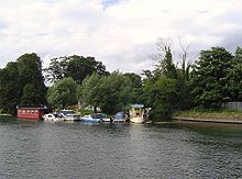
Colne Brook joins the River Thames at Hythe End
[v · Legend
Unused urban continuation backward
River Colne (from source)
Unused transverse waterway Unused transverse waterway Unused waterway turning from right Unused straight waterway
River Gade
Urban transverse track Transverse waterway with floodgate left Unknown BSicon "uxABZlg" Unused straight waterway
Grand Union Canal
Unused waterway turning from left + Unknown BSicon "POINTERd"
Urban straight track Unused straight waterway
River Colne
Unused straight waterway Unknown BSicon "ueABZrg" Unused transverse waterway Unused waterway turning right
Junction with canal
Unused transverse waterway Unknown BSicon "uexABZlg" Urban straight track
River Chess
Unknown BSicon "uSTRfl" Waterway turning to left Urban track turning from right
Rickmansworth
Unknown BSicon "uxABZlf" Urban track turning from right Waterway with unused branch to left Unused waterway turning from right
Unknown BSicon "uxWEIRg" Unknown BSicon "uFGATEu" Unknown BSicon "uFGATEu" Unused straight waterway
Batchworth Locks
Unused straight waterway Waterway turning to left Unknown BSicon "uABZlg" Unknown BSicon "uxWEIRg"
Weir
Unknown BSicon "uexAKRZu" Unknown BSicon "uAKRZq" Unknown BSicon "uAKRZu" Unknown BSicon "uexAKRZu"
A404 London Road
Unknown BSicon "uexABZrg" Unused transverse waterway
Unknown BSicon "uxJUNC" + Urban straight track
Unused waterway turning right
Unknown BSicon "uxWEIRg" Unknown BSicon "uFGATEu"
Weir
Unused waterway turning from left Unused waterway with junction to right Unknown BSicon "uFGATEu"
Unused straight waterway Unused waterway with junction to left Unused transverse waterway Unknown BSicon "ueABZlg"
Feeder
Unused waterway turning left Unknown BSicon "uexABZ3lf" Urban track turning from right Urban straight track
Unknown BSicon "uxABZlf" Unknown BSicon "uABZlg"
Navigable branch
Unknown BSicon "uxWEIRg" Unknown BSicon "uFGATEu"
Weir
Unused waterway turning from left Unknown BSicon "uxJUNC"
Unknown BSicon "uxJUNCrd" + Urban straight track
Troy Cut
Unused straight waterway Unused straight waterway Urban straight track
Unknown BSicon "uexABZrg" Unused waterway turning right Unknown BSicon "uFGATEu"
Unused waterway under railway bridge Transverse track Waterway under railway bridge
Railway bridge
Unused waterway with junction to left Unused transverse waterway Unknown BSicon "ueKRZo" Unused waterway turning from right
Frays River
Unknown BSicon "uxWEIRg" Waterway turning from left Waterway turning to right Unused straight waterway
Weir
Unused transverse waterway Unknown BSicon "uexABZlg" Unknown BSicon "uFGATEu" Unused straight waterway
River Misbourne
Unknown BSicon "uexAKRZu" Unknown BSicon "uAKRZu" Unknown BSicon "uexAKRZu" Unknown BSicon "uexAKRZu"
A40 road
Unknown BSicon "uxWEIRg" Unknown BSicon "uFGATEu"
Unused straight waterway + Unknown BSicon "POINTERl"
Unused straight waterway
Shire Ditch
Unknown BSicon "uexAKRZu" Unknown BSicon "uAKRZu" Unknown BSicon "uexAKRZu" Unknown BSicon "uexAKRZu"
A4077
Unknown BSicon "uexABZrg" Unknown BSicon "ueKRZo" Unused waterway turning right Unused straight waterway
Unused waterway turning from right Unused straight waterway Urban straight track Unused straight waterway
Alder Bourne
Unknown BSicon "uexABZrg" Unused waterway with junction to right Urban straight track Unused straight waterway
Unknown BSicon "uxAKRZu2" Unused straight waterway Unknown BSicon "uFGATEu" Unused straight waterway
M25 Motorway
Unused straight waterway + Unknown BSicon "POINTERl"
Unused straight waterway Waterway turning to left Urban track turning from right Unused straight waterway
Colne Brook
Unknown BSicon "uxAKRZu2" Unused straight waterway Unused waterway turning from left Unknown BSicon "ueKRZo" Unused waterway turning right
M25 motorway
Unknown BSicon "uxKRZu" Unknown BSicon "uxKRZu" Unknown BSicon "uxKRZu" Waterway T-junction to right
Slough Arm
Unused straight waterway Unused straight waterway Unknown BSicon "uexABZrg" Unknown BSicon "ueKRZo"
River Pinn
Unused straight waterway Unused straight waterway Unused straight waterway Waterway turning to left
Grand Union Canal
Unused waterway under railway bridge Unused waterway under railway bridge Unused waterway under railway bridge Transverse track Transverse track
Reading - Paddington Railway
Unknown BSicon "uxAKRZu2" Unused waterway with junction to left Unknown BSicon "uexABZlg"
M25 Motorway
Unused straight waterway Unused straight waterway Unused waterway with junction to left
Unused waterway turning from right + Unknown BSicon "POINTERd"
River Colne
Unknown BSicon "uxAKRZu2" Unknown BSicon "uxAKRZu2" Unknown BSicon "uxAKRZu2" Unknown BSicon "uxAKRZu2"
M4 Motorway
Unused straight waterway
Unused straight waterway + Unknown BSicon "POINTERl"
Unused straight waterway Unknown BSicon "uxWEIRg"
Bigley Ditch
Unused straight waterway Unused waterway turning left Unknown BSicon "uexABZlg" Unused waterway with junction to left Unused waterway turning from right
Unknown BSicon "uexAKRZu" Unknown BSicon "uAKRZq" Unknown BSicon "uexAKRZu" Unknown BSicon "uexAKRZu" Unknown BSicon "uexAKRZu"
A4 Colnbrook Bypass
Unused straight waterway Unknown BSicon "uxAKRZu2" Unused straight waterway Urban tunnel straight track
M25 Motorway
Unknown BSicon "uexABZrg" Unused transverse waterway Unused waterway with junction to right Unused straight waterway Urban tunnel straight track
Poyle Channel
Unused straight waterway Unused straight waterway Unused straight waterway Urban tunnel straight track
Culvert under Heathrow Airport
Unused straight waterway Unused straight waterway Unused straight waterway Unused waterway turning left
Duke of Northumberland's River
Unused straight waterway Unused waterway turning from left Unused waterway turning right Unused waterway with junction to left Unknown BSicon "uexABZ3lg"
Longford River
Unused straight waterway Unused straight waterway Unknown BSicon "uexAKRZu" Unused straight waterway
A3044 Stanwell Moor
Unused straight waterway Unused straight waterway Unknown BSicon "uxAKRZu2" Unknown BSicon "uxAKRZu2"
M25 Junction 14 slip road
Unused straight waterway Unused straight waterway Unused straight waterway Unknown BSicon "uexAKRZu"
A3044 Stanwell Moor
Unused straight waterway Unused straight waterway Unknown BSicon "uexAKRZu" Unknown BSicon "uexAKRZu"
A3113 Airport Way
Unused straight waterway Unknown BSicon "uxAKRZu2" Unused straight waterway Unused straight waterway
M25 motorway
Unused straight waterway Unused straight waterway Unknown BSicon "uexABZrg" Unused waterway turning right
Unused straight waterway
Unused straight waterway + Unknown BSicon "POINTERl"
Unused waterway with junction to left Unused waterway turning from right
Wraysbury River
Unused straight waterway Unused straight waterway Unused straight waterway
Unused straight waterway + Unknown BSicon "POINTERl"
Bonehead Ditch
Unused straight waterway + Unknown BSicon "POINTERl"
Unused straight waterway Unknown BSicon "uexABZrg" Unused waterway turning right
Colne Brook
Unused waterway under railway bridge Unused waterway under railway bridge Track turning from right Unused straight waterway
Railway bridge
Unused straight waterway Unknown BSicon "uexAKRZu" Unknown BSicon "AKRZu" Unknown BSicon "uexAKRZu"
A30 Staines Bypass
Unused straight waterway Unused straight waterway Straight track Unused waterway with junction to left Unused transverse waterway
River Ash
Unused straight waterway Unused straight waterway Track turning left Unused waterway under railway bridge
Railway bridge
Unused straight waterway Unused waterway turning left Unused transverse waterway Unknown BSicon "uexABZlg"
Wraysbury River
Unused straight waterway Unknown BSicon "uexAKRZu"
A308 Clarence St, Staines
Unknown BSicon "ueABZ3lf" Unknown BSicon "uAKRZRu2" Urban transverse track Unknown BSicon "ueABZ3lf" Unknown BSicon "uCONTl"
River Thames

The Colne Brook is a river in England that branches off the River Colne at Uxbridge Moor and flows into the River Thames at Hythe End, just below Bell Weir Lock.

The river leaves the River Colne at Uxbridge Moor and flows close by it until West Drayton. It then passes under the M25 motorway at the M4 motorway interchange and flows through the village of Colnbrook. South of Colnbrook it receives another feed from the River Colne by the Poyle Channel and runs between Horton and Wraysbury Reservoir. Its course then goes close to the gravel pits at Wraysbury which make up a Site of Special Scientific Interest, before running into the River Thames between the M25 Runnymede Bridge and Bell Weir Lock.

See also

  • Tributaries of the River Thames
  • List of rivers in England


Next confluence upstream River Thames Next confluence downstream
Jubilee River (north) Colne Brook River Colne (north)


Coordinates: 51°26′19″N 0°32′06″W / 51.43861°N 0.535°W / 51.43861; -0.535


Wikimedia Foundation. 2010.

Игры ⚽ Поможем написать реферат

Look at other dictionaries:

  • Colne Water — This article is about Colne Water in Lancashire. For other uses, see River Colne. Colne Water is a watercourse running through the Lancashire town of Colne. Colne Water is formed at Covey Bridge near Laneshaw Bridge by the confluence of the River …   Wikipedia

  • River Colne, Hertfordshire — The Colne is a river in England. It flows mainly through Hertfordshire and forms the boundary between the South Bucks district of Buckinghamshire and the London Borough of Hillingdon. It is a tributary of the River Thames and flows into the River …   Wikipedia

  • River Colne — There are several different rivers named River Colne in England: River Colne, Essex passing through Colchester River Colne, Hertfordshire tributary of the River Thames, passing through London Colney and other parts of Hertfordshire,… …   Wikipedia

  • River Colne, Essex — This article is about the River Colne in Essex. For other uses, see River Colne. The River Colne near Colchester The River Colne is a small river that runs through Colchester, England. It is not a tributary of any other river, instead having an… …   Wikipedia

  • River Colne, West Yorkshire — The River Colne rises in the Pennines in West Yorkshire, England. It flows through the Colne Valley passing through the villages of Marsden, Slaithwaite and Milnsbridge to Huddersfield and then on to Cooper Bridge where it joins the River Calder …   Wikipedia

  • Liste des cours d'eau d'Angleterre — Cet article présente une liste des cours d eau d Angleterre, classés par position géographique dans le sens inverse des aiguilles d une montre. Ils passent par l Angleterre et se jettent dans les mers qui bordent le pays. Pour l Esk, la Tweed, la …   Wikipédia en Français

  • River Thames — Thames redirects here. For other uses, see Thames (disambiguation). Coordinates: 51°29′56″N 0°36′31″E / 51.4989°N 0.6087°E / 5 …   Wikipedia

  • River Chess — Coordinates: 51°42′22″N 0°36′36″W / 51.706°N 0.610°W / 51.706; 0.610 …   Wikipedia

  • River Ouzel — River Lovat redirects here. For the river in Russia, see Lovat River. River Ouzel between Northall and Billington. The River Ouzel ( …   Wikipedia

  • Colnbrook — Coordinates: 51°29′01″N 0°31′20″W / 51.4835°N 0.5221°W / 51.4835; 0.5221 …   Wikipedia

Share the article and excerpts

Direct link
Do a right-click on the link above
and select “Copy Link”