- Kettle Falls Bridges
-
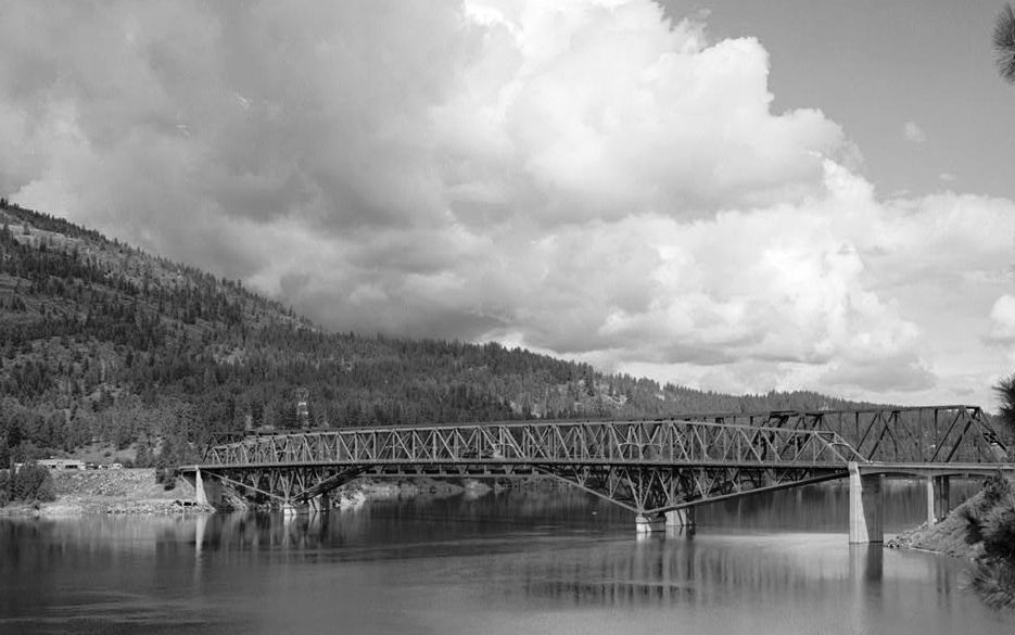
Kettle Falls Bridges Carries BNSF Railway (north bridge)
SR 20/U.S. 395 (south bridge)Crosses Columbia River Locale Kettle Falls, Washington Design Steel cantilever Opened May 3, 1941 Columbia River Bridge at Kettle Falls
Area: less than one acre Built: 1941 Architectural style: Other, Steel Through Truss Governing body: State MPS: Bridges of Washington State MPS NRHP Reference#: 95000260[1] Added to NRHP: March 28, 1995 The Kettle Falls Bridges is the collective name for a pair of steel cantilever bridges carrying State Route 20/U.S. Route 395 and the BNSF Railway across the Columbia River at Kettle Falls, Washington. The south bridge carries motor vehicle traffic while the similar northern span is used for rail.
Contents
History
On May 3, 1941, the Columbia River road bridge at Kettle Falls opened to traffic. Both bridges were constructed to replace bridges flooded by waters rising behind the Grand Coulee Dam to form Franklin D. Roosevelt Lake. The bridges are historically significant because they feature the longest central spans of any highway bridge built in Washington state during the 1940s. In 1995 the steel truss road bridge was added to the National Register of Historic Places.[2]
Road bridge
The road bridge, with a total length of 1,266 feet (386 m), was completed in 1941, replacing a 1929 steel deck truss bridge whose location was to be partly submerged by Lake Roosevelt as it backed up behind the new Grand Coulee Dam. The bridge initially carried Primary State Highway 3, later designated U.S. Route 395. The bridge is primarily a steel cantilever structure with an almost horizontal top chord and sloping bottom chords, designed to reduce the height of the concrete piers. Concrete T-beam approach spans are used, with unusual sloping concrete bets that serve to laterally brace the first piers supporting the steel structure against pressure of embankment fill.[3]
The central span is 300 feet (91 m) long, with 150-foot (46 m) cantilevered spans for a total span between piers of 600 feet (180 m). Anchor spans are 225 feet (69 m), with a 143-foot (44 m) east approach span and a 73-foot (22 m) west approach span. The two-lane bridge was the longest span to be built in Washington between 1941 and 1950.[3] The bridge was designed by the Washington Department of Highways, R.W. Finke, designer, and was fabricated by the L. Romano Engineering Company of Seattle. The project was financed by the U.S. Bureau of Reclamation as part of the Grand Coulee project. The crossing was originally intended to be a single dual-use bridge, carrying the highway and the Great Northern Railroad, which also had to be relocated, but a joint contract could not be negotiated with the railroad, and a parallel rail crossing was built with similar construction.[4]
The Kettle Falls bridge is similar to the Grand Coulee Bridge, built in 1935, but with refinements to aesthetics by replacing the Coulee Bridge's laced channels with built-up punched channel bracing. The design was repeated on a larger scale at the Northport Bridge in 1948. The bridge opened on May 3, 1941. The old bridge was disassembled, except for its piers, that summer.[4]
The Kettle Falls road bridge was listed on the National Register of Historic Places on March 28, 1995.[1]

Coordinates: 48°37′33″N 118°07′01″W / 48.6257333°N 118.11681666°W
References
- ^ a b "National Register Information System". National Register of Historic Places. National Park Service. 2010-07-09. http://nrhp.focus.nps.gov/natreg/docs/All_Data.html.
- ^ Long, Priscilla; Gibson, Elizabeth (October 23, 2004). "Columbia River Bridge at Kettle Falls opens to traffic on May 3, 1941.". HistoryLink. http://www.historylink.org/index.cfm?DisplayPage=output.cfm&file_id=7091. Retrieved 2009-09-10.
- ^ a b Krier, Robert H., Jr.; Barber, J. Byron; Bruce, Robert; Holstine, Craig (December 3, 1991). "National Register of Historic Places Registration Form: Columbia River Bridge at Kettle Falls". https://fortress.wa.gov/dahp/wisaard/documents/RN/0/0/583.pdf. Retrieved 9 September 2011.
- ^ a b Hadlow, Robert W. (August 1993). "Columbia River Bridge at Kettle Falls". Historic American Engineering Record. http://hdl.loc.gov/loc.pnp/hhh.wa0436. Retrieved 9 September 2011.
External links
- Columbia River Bridge at Kettle Falls, U.S. Route 395 spanning Columbia River, Kettle Falls vicinity, Stevens, WA, at the Historic American Engineering Record
U.S. National Register of Historic Places Topics Lists by states Alabama • Alaska • Arizona • Arkansas • California • Colorado • Connecticut • Delaware • Florida • Georgia • Hawaii • Idaho • Illinois • Indiana • Iowa • Kansas • Kentucky • Louisiana • Maine • Maryland • Massachusetts • Michigan • Minnesota • Mississippi • Missouri • Montana • Nebraska • Nevada • New Hampshire • New Jersey • New Mexico • New York • North Carolina • North Dakota • Ohio • Oklahoma • Oregon • Pennsylvania • Rhode Island • South Carolina • South Dakota • Tennessee • Texas • Utah • Vermont • Virginia • Washington • West Virginia • Wisconsin • WyomingLists by territories Lists by associated states Other Crossings of the Columbia River Upstream
Northport BridgeKettle Falls Bridges Downstream
Gifford-Inchelium FerryCategories:- Bridges over the Columbia River
- Buildings and structures in Stevens County, Washington
- Transportation in Stevens County, Washington
- National Register of Historic Places in Washington (state)
- Buildings and structures completed in 1941
- Buildings and structures in Ferry County, Washington
- Cantilever bridges
- Bridges on the National Register of Historic Places in Washington (state)
- Road bridges in Washington (state)
- Railroad bridges in Washington (state)

Wikimedia Foundation. 2010.