- Conargo Shire
-
Conargo Shire
New South Wales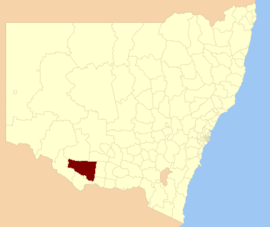
Location in New South WalesPopulation: 1,700(2009)[1] • Density: 0.16/km² (0.4/sq mi) Area: 8751 km² (3,378.8 sq mi) Mayor: Norm McAllister Council Seat: Conargo (Offices in neighbouring Deniliquin, 122 End Street) Region: Riverina State District: Murray-Darling Federal Division: Farrer LGAs around Conargo Shire: Hay Murrumbidgee Murrumbidgee Wakool Conargo Shire Jerilderie Murray Deniliquin Berrigan 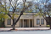 Conargo Shire Council chambers in Deniliquin
Conargo Shire Council is a local government area in New South Wales, Australia. It is the smallest (by population) Local Government Area in New South Wales. Conargo Shire was established in 1907. In 2001 the former Windouran shire was absorbed into Conargo Shire. This amalgamation resulted in an additional 5090 square kilometres and another 387 residents. It is divided into four wards, and contains six villages - Conargo, Blighty, Mayrung, Pretty Pine, Wanganella and Booroorban.
Before mergers in recent decades it was a common in New South Wales for rural shires to have their offices in an adjacent rural municipality (rural town). The only surviving case is Conargo Shire Council's offices in Deniliquin.
Council
Conargo Shire Council is composed of eight councillors elected proportionally. The shire is divided into four wards, each electing two councillors. The mayor is not directly elected.[2] The current makeup of the council is as follows:[2]
Party Councillors Independents and Unaffiliated 8 Total 8 The current council, elected in 2008, is:[2]
Ward Councillor Party Notes A Ward Bernard Clancy Unaffiliated Mac Wallace Unaffiliated B Ward Nick Metcalfe Independent Norm Brennan Independent C Ward Norm McAllister Unaffiliated Mayor Donald Henderson Independent D Ward Peter McCrabb Unaffiliated Sally Dye Independent Deputy Mayor References
- ^ Australian Bureau of Statistics (30 March 2010). "Regional Population Growth, Australia, 2008–09". http://www.abs.gov.au/ausstats/abs@.nsf/Latestproducts/3218.0Main%20Features42008-09?opendocument&tabname=Summary&prodno=3218.0&issue=2008-09&num=&view=. Retrieved 3 June 2010.
- ^ a b c "Conargo Shire Council". 2008 Election results. Electoral Commission NSW. http://www.lg.elections.nsw.gov.au/LGE2008/result.Conargo.html. Retrieved 2009-06-16.[dead link]
Coordinates: 35°19′S 145°09′E / 35.317°S 145.15°E
Towns in the Conargo Shire Local Government Area Blighty · Booroorban · Conargo · Mayrung · Pretty Pine · Wanganella
Local Government Areas of the Riverina Cities: Albury · Griffith · Wagga Wagga
Towns: Deniliquin
Shires: Balranald · Berrigan · Carrathool · Conargo · Coolamon · Cootamundra · Corowa · Greater Hume · Gundagai · Hay · Jerilderie · Junee · Leeton · Lockhart · Murray · Murrumbidgee · Narrandera · Temora · Tumbarumba · Tumut · Urana · Wakool
Local Government Areas of New South Wales Metropolitan Sydney Inner SydneyAshfield · Botany Bay · Burwood · Canada Bay · Canterbury · Hurstville · Kogarah · Lane Cove · Leichhardt · Manly · Marrickville · Mosman · North Sydney · Randwick · Rockdale · Strathfield · Sydney · Waverley · Willoughby · WoollahraOuter SydneyAuburn · Bankstown · Blacktown · Camden · Campbelltown · Fairfield · The Hills · Holroyd · Hornsby · Hunter's Hill · Ku-ring-gai · Liverpool · Parramatta · Penrith · Pittwater · Ryde · Sutherland · WarringahSydney SurroundsMid North Coast Bellingen · Clarence Valley · Coffs Harbour · Greater Taree · Kempsey · Nambucca · Port Macquarie-Hastings · Lord Howe IslandMurray Albury · Balranald · Berrigan · Conargo · Corowa · Deniliquin · Greater Hume · Jerilderie · Murray · Tumbarumba · Urana · Wakool · WentworthMurrumbidgee Carrathool · Coolamon · Cootamundra · Griffith · Gundagai · Hay · Junee · Leeton · Lockhart · Murrumbidgee · Narrandera · Temora · Wagga WaggaHunter Cessnock · Dungog · Gloucester · Great Lakes · Lake Macquarie · Maitland · Muswellbrook · Newcastle · Port Stephens · Singleton · Upper HunterIllawarra Richmond Tweed Southeastern Bega · Bombala · Boorowa · Cooma-Monaro · Eurobodalla · Goulburn Mulwaree · Harden · Palerang · Queanbeyan · Snowy River · Tumut · Upper Lachlan · Yass Valley · YoungNorthern Armadale Dumaresq · Glen Innes-Severn · Gunnedah · Guyra · Gwydir · Inverell · Liverpool Plains · Moree Plains · Narrabri · Tamworth · Tenterfield · Uralla · WalchaCentral West North Western Far West Categories:- Local Government Areas of the Riverina, New South Wales
- Local Government Areas of New South Wales
- Riverina geography stubs


Wikimedia Foundation. 2010.