- Connecticut River Walk Park
-
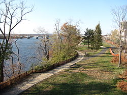

The Connecticut River Walk is partially-constructed park and bikeway in Springfield, Massachusetts, USA, along the banks of New England's largest river, the Connecticut River. Currently, Springfield's section of this park is 3.7 miles long, running from Chicopee, Massachusetts to the South End Bridge in Springfield, Massachusetts. Unique features of the trail include its path alongside an active - and soon-to-be the United States' first high-speed - train line, making it a "rail-with-trail," and its passing in very close proximity to the Naismith Memorial Basketball Hall of Fame.[1] The longest river in New England, the Connecticut River is the Knowledge Corridor's most prominent natural asset. For centuries it has been a source of regional identity and pride; however, currently most residents are cut off from it by Interstate 91 - a 1960s-era elevated highway, which has become a major inhibitor to Springfield's economic and recreational riverfront growth, especially in recent years.[2]
Proposed additions
The Connecticut River Walk and Bikeway is under development, and the first two sections are open to the public. The segment in Springfield itself is 3.7 miles long, and a second segment in Agawam, Massachusetts, is 1.7 miles long. In total, the route is planned to run for 20 miles, through city-owned floodplain alongside the Connecticut River.[3]
Interstate 91 inhibiting access to the Connecticut River Walk
Since the 1960s, Springfielders have been cut off from the economic and recreational development opportunities of the Connecticut River by Interstate 91.[2] [4] Connecticut River Walk & Bikeway was conceived to revitalize the Connecticut Riverfront, restoring it as a focus of life in the region. Unfortunately, Interstate 91 and its tangential developments - for example, above-grade parking lots built underneath it; tall, earthen, grassy mounds constructed beside it; and even double-sided, 20-foot limestone walls between the city and the river- pose formidable barriers to pedestrians reaching the Connecticut River Walk from Metro Center, Springfield, Massachusetts.[5][6]
The park features one 60 foot-tall footbridge behind LA Fitness in the Basketball Hall of Fame complex that allows visitors access to the river walk. The 3.7 mile park features two other entrance points. As of 2011, a testament to how difficult it is to reach the Connecticut River Walk is how infrequently the park is used for passive recreation. In 2011, on Wednesdays at 12:15pm, the city of Springfield holds "lunchtime walks" to "promote" the park.[1][7]
In 2010, Boston's Urban Land Institute proposed a vision for reuniting Springfield with its riverfront; however, as of 2011, Interstate 91 remains a physical barrier between Springfield, the Connecticut River, and the Basketball Hall of Fame.[8] It remains to be seen whether Interstate 91 will be re-routed to its originally planned route along West Springfield's Riverdale Road, (the original highway construction for I-91,) freeing up Springfield's most valuable land; or whether officials will demolish large portions of the highway's tangential developments, making it easier to access the riverfront; or whether some compromise will be reached.[9][10]
References
- ^ a b "Home / Parks / Parks Facilities and Use / River Walk". Website of Springfield City Council. Springfield City Council. http://www.springfieldcityhall.com/Park/riverwalk.0.html. Retrieved 27 July 2011.
- ^ a b "Making Connections - Envisioning Springfield's North End". ScholarWorks@UMass Amherst. University of Massachusetts - Amherst. http://scholarworks.umass.edu/cgi/viewcontent.cgi?article=1004&context=larp_grad_research&sei-redir=1#search=%22http%3A%2F%2Fscholarworks.umass.edu%2Fcgi%2Fviewcontent.cgi%3Farticle%3D1004%26context%3Dlarp_grad_research. Retrieved 27 July 2011.
- ^ "Home / Parks / Parks Facilities and Use / River Walk / More about River Walk". Website of Springfield City Council. Springfield City Council. http://www.springfieldcityhall.com/Park/riverwalk-more.0.html. Retrieved 27 July 2011.
- ^ http://homepage.mac.com/kefkafloyd/valleyroads/91.html
- ^ http://www.parkspa.com/facilities.shtml
- ^ http://www.parkspa.com/facilities.shtml
- ^ http://pvpc.org/resources/landuse/ct_rivwalk.pdf
- ^ http://www.springfieldcityhall.com/planning/fileadmin/Planning_files/1200_Hall_of_Fame_Building_Plans/Springfield_TAP_Presentation_FINAL_diagrams.pdf
- ^ http://www.springfieldcityhall.com/planning/fileadmin/Planning_files/1200_Hall_of_Fame_Building_Plans/Springfield_TAP_Presentation_FINAL_diagrams.pdf
- ^ http://scholarworks.umass.edu/cgi/viewcontent.cgi?article=1007&context=larp_ms_projects&sei-redir=1#search=%22umass%201-91%20urban%20design%20springfield%22
•Coordinates: 42°5′53.07″N 72°35′26.05″W / 42.098075°N 72.5905694°W
Categories:

Wikimedia Foundation. 2010.