Musgrave Park, Brisbane

Musgrave Park, Brisbane
Musgrave Park

Musgrave Park is a park located in South Brisbane, a suburb in the city of Brisbane, the capital city of the Australian state of Queensland. Musgrave Park is nestled between Edmonstone, Russell and Cordelia Streets and is approximately 3000m2. The park sits adjacent to Brisbane State High School, and Musgrave Park Pool.

Contents

History

The South Brisbane Recreation Reserve (as it was originally known) was created in 1856.[1]

In 1867, it was proposed to build a public grammar school (Brisbane State High School) adjacent to the reserve.[2]

Current use

It is home to the Jagera Arts Centre, and is one of the few remaining green spaces left in Brisbane's inner city. On August 24, 1998, after 20 years of legal struggles with the Queensland State Government, the Musgrave Park Aboriginal Corporation[3] (MPAC) secured a lease to build a cultural centre on portions of the park.[4]. The park holds special significance to the local Indigenous population due to a past restriction barring Aboriginies from crossing the park and entering the city of Brisbane. Notably, it has historically been a sacred site to the native Murri people, being the site of a buried bora ring. However, this has recently been disputed by the State Government.

The park plays host each year to the Greek festival – Paniyiri, the National Aboriginal and Islander Day of Celebration (NAIDOC) Park Day, the Medieval Fayre, and the Lesbian and Gay Brisbane Pride Festival Fair Day.

In 2009, the park was closed to Indigenous persons for a time whilst the Brisbane City Council performed a degree of tests regarding the land surveying of the immediate area. During these tests, a number of Council staff were assaulted by heavily intoxicated persons. There have been continued confrontations between police, council workers and park residents.

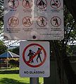
In response to ongoing violence and serious assault in Musgrave park, a local resident put up a series of satirical safety signs in February 2010. The signs have since been removed.

Gallery

References

  1. ^ "South Brisbane". Queensland Places. University of Queensland. http://queenslandplaces.com.au/south-brisbane. Retrieved 9 August 2011. 
  2. ^ "PUBLIC GRAMMAR SCHOOL—A SUGGESTION.". The Brisbane Courier (Qld. : 1864 - 1933) (Qld.: National Library of Australia): p. 3. 28 October 1867. http://nla.gov.au/nla.news-article1288176. Retrieved 9 August 2011. 
  3. ^ [musgraveparkculturalcentre.org.au]
  4. ^ FAIRA: Historic handover at Musgrave Park

External links

Coordinates: 27°28′44″S 153°01′00″E / 27.4790°S 153.0166°E / -27.4790; 153.0166


Wikimedia Foundation. 2010.

Игры ⚽ Поможем сделать НИР

Look at other dictionaries:

  • Musgrave Park — may refer to: Musgrave Park, Belfast Musgrave Park, Brisbane, Queensland, Australia Musgrave Park, Cork, Ireland Musgrave Park Hospital, Belfast This disambiguation page lists articles associated with the same title. If an …   Wikipedia

  • Musgrave — may refer to one of the following: Contents 1 Locations 2 Organizations 3 Engineering 4 People 5 Literat …   Wikipedia

  • Brisbane — Saltar a navegación, búsqueda Este artículo trata sobre la ciudad de Brisbane. Para saber más sobre el río, véase Río Brisbane. Brisbane …   Wikipedia Español

  • Brisbane — This article is about the Australian metropolis. For the local government area, see City of Brisbane. For other uses, see Brisbane (disambiguation). Brisbane Queensland …   Wikipedia

  • Brisbane State High School — Infobox Aust school name = Brisbane State High School motto = la. Scientia est Potestas ( Knowledge is Power ) established = 1921 principal = David Sutton | Captains = Paddy Keys Macpherson, Chloe Forsyth, Joel Mccomber and Emily Beaton | type =… …   Wikipedia

  • List of Brisbane-related topics — The list includes articles about Brisbane, Queensland, Australia.Brisbane article lists::* Brisbane bus stations::* Brisbane railway stations::* Brisbane ferry wharves::* Brisbane suburbs::* Mayors and Lord Mayors of Brisbane::* Schools in… …   Wikipedia

  • South Brisbane, Queensland — Infobox Australian Place | type = suburb name = South Brisbane city = Brisbane state = qld caption = |South Brisbane is dominated by riverside high rise apartments. lga = Brisbane City Council, Dutton Park Ward postcode = 4101 pop = 4,285 (2006)… …   Wikipedia

  • Lady Musgrave Island — is a 14 ha coral cay in the Great Barrier Reef, with a 1192 ha surrounding reef. The island is the second island in the Great Barrier Reef chain of islands (with the first being Lady Elliot Island), and is most easily reached from the town of… …   Wikipedia

  • Capricornia Cays National Park — Capricornia Cays is both a national park and a scientific national park in Queensland (Australia), located 486 km and 472 km north of the state capital Brisbane respectively. Capricornia Cays National Park protects eight vegetated coral cays in… …   Wikipedia

  • Souths Logan Magpies — Infobox nrl club | clubname = Souths Logan Magpies fullname = Souths Logan Magpies emblem = Magpie colours = black, white, blue, gold, green founded = 1921 (as Carltons), 1933 (as Souths), 2003 as Souths Logan sport = Rugby league league =… …   Wikipedia

Share the article and excerpts

Direct link
Do a right-click on the link above
and select “Copy Link”