- Kodagu district
-
Kodagu
ಕೊಡಗು
— district — 
Coordinates 12°25′15″N 75°44′23″E / 12.4208°N 75.7397°ECoordinates: 12°25′15″N 75°44′23″E / 12.4208°N 75.7397°E Country India Region Malnad State Karnataka Division Mysore Division Subdistrict(s) Madikeri, Somwarpet, Virajpet Headquarters Madikeri Deputy Commissioner K.R. Niranjan (2011) Parliamentary constituency Mysore Lok Sabha constituency Population
548,561[1] (2001[update])
• 134 /km2 (347 /sq mi)
• 13.75Literacy
• Male
• Female78%
• 83.7%
• 72.3%Official languages Kannada Language(s) Kannada, Kodava takk Time zone IST (UTC+05:30) Area 4,102 square kilometres (1,584 sq mi)[1] Climate
• Precipitation
Temperature
• Summer
• WinterTropical Wet (Köppen)
• 2,725.5 mm (107.30 in)
• 28.6 °C (83.5 °F)
• 14.2 °C (57.6 °F) Portal: Karnataka
 Website kodagu.nic.in Kodagu (Kannada: ಕೊಡಗು), also known by its anglicised former name of Coorg, is an administrative district in Karnataka, India. It occupies an area of 4,102 square kilometres (1,584 sq mi) in the Western Ghats of southwestern Karnataka. As of 2001, the population was 548,561, 13.74% of which resided in the district's urban centres, making it the least populous of the 30 districts in Karnataka.[2] Kodagu is well known in the world for coffee and its "brave warriors", like Field Marshal K. M. Cariappa.
Madikeri (English: Mercara) is the headquarters of the Kodagu. The district is bordered by Dakshina Kannada district to the northwest, Hassan district to the north, Mysore district to the east,Kannur district of Kerala to the southwest, and the Wayanad district of Kerala to the south.
Kodava is home to the native speakers of Kodava language.[3] As per 1991 census, the speakers of Kodava made up 0.25% of the total population of Karnataka.[citation needed] According to Karnataka Kodava Sahitya Academy, apart from Kodavas, 18 other ethnic groups speak Kodava Takk in and outside the district including Heggade, Iri, Koyava, Banna, Madivala, Hajama, Kembatti, and Meda.[4] Though the language has no script, recently German linguist Gregg M. Cox developed a new writing system for the language known as the Coorgi-Cox alphabet, used by a number of individuals within Kodagu.[5] Lately, some organizations including the Codava National Council and Kodava Rashtriya Samiti are demanding Kodava homeland status and autonomy to Kodagu district.[6] [7]
Contents
History
Main articles: History of Kodagu and Captivity of Kodavas at SeringapatamThe Kodavas were the earliest agriculturists in Kodagu, having lived there for centuries. During this time, South Indian dynasties such as the Kadambas, the Gangas, the Cholas, the Chalukyas, the Rastrakutas, the Hoysalas and the Vijaynagar Rayas ruled over Kodagu. Despite the Kodavas being known in India as "brave warriors" and members of the Indian warrior caste, Kodagu did not have indigenous rulers as the Kodavas failed to evolve political consensus.
Geography
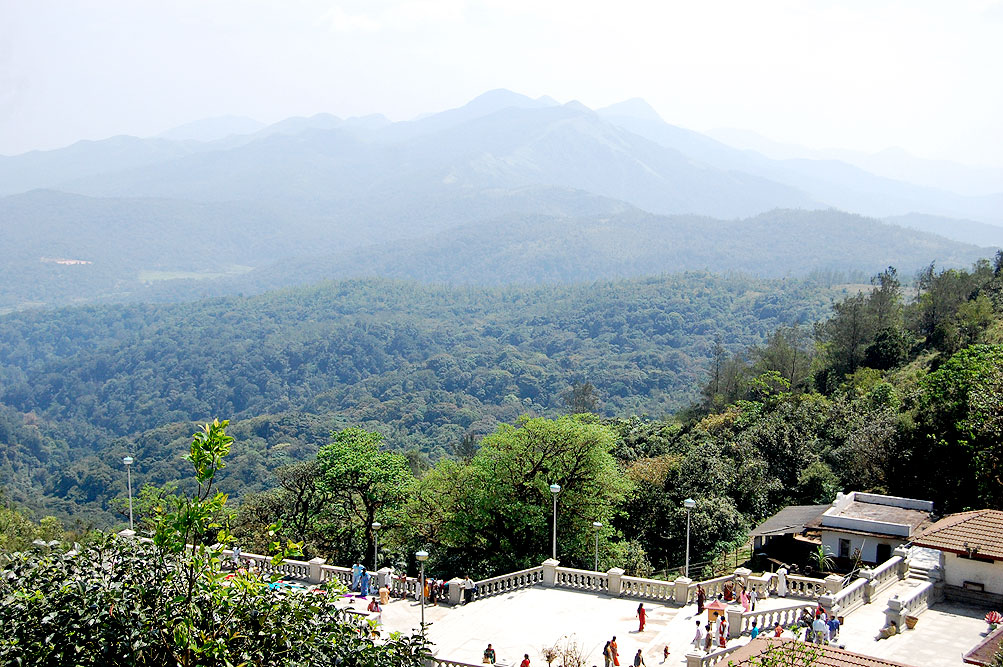
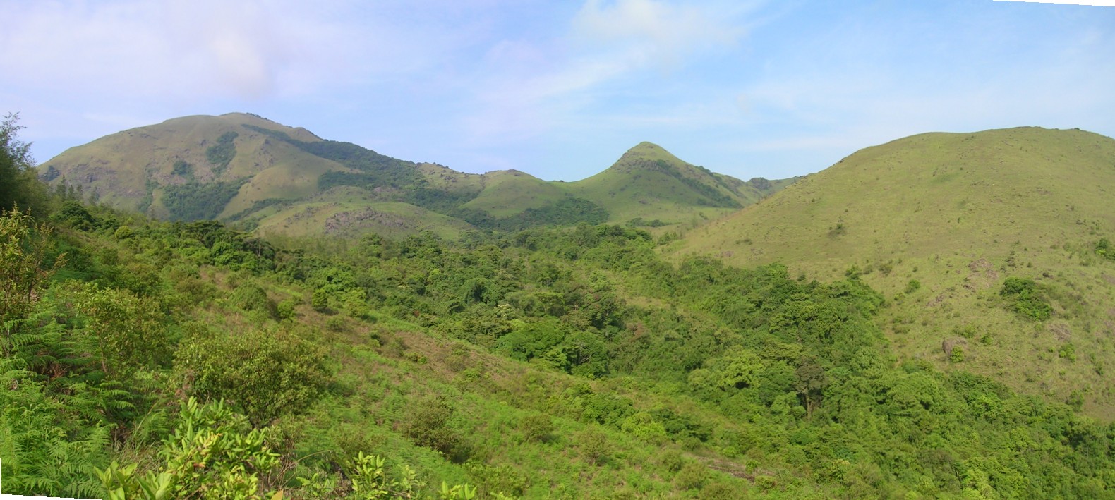
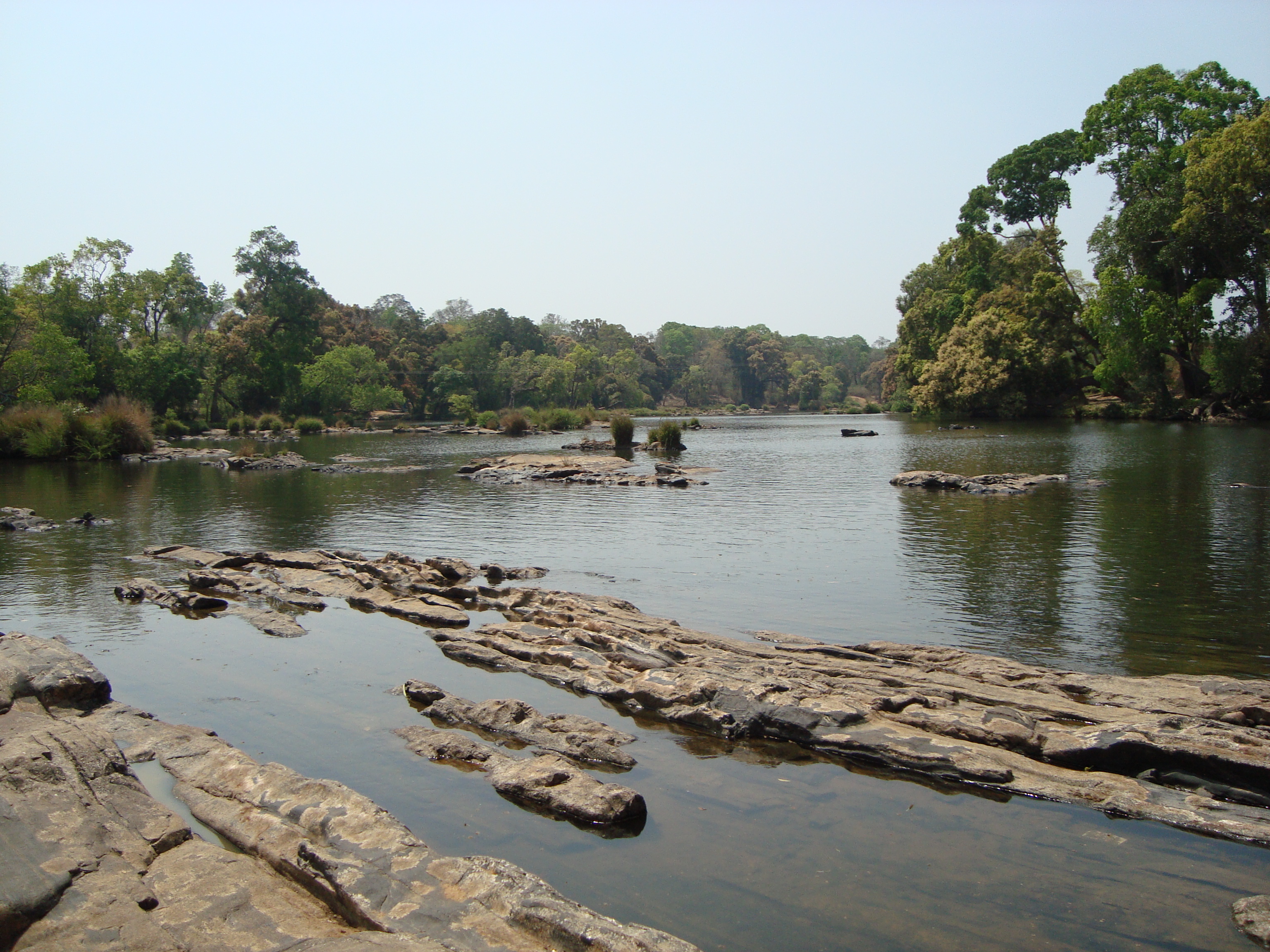
Kodagu is located on the eastern slopes of the Western Ghats. It has a geographical area of 4,102 km2 (1,584 sq mi).[8] The district is bordered by Dakshina Kannada district to the northwest, Hassan district to the north, Mysore district to the east, Kannur district of Kerala to the southwest, and Wayanad district of Kerala to the south. It is a hilly district, the lowest elevation of which is 900 metres (3,000 ft) above sea-level. The highest peak, Tadiandamol, rises to 1,750 metres (5,740 ft), with Pushpagiri, the second highest, at 1,715 metres (5,627 ft). The main river in Kodagu is the Kaveri (Cauvery), which originates at Talakaveri, located on the eastern side of the Western Ghats, and with its tributaries, drains the greater part of Kodagu.
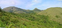 View of Tadiandamol
In July and August, rainfall is intense, and there are often showers into November. Yearly rainfall may exceed 4,000 millimetres (160 in) in some areas. In dense jungle tracts, rainfall reaches 3,000 to 3,800 millimetres (120 to 150 in) and 1,500 to 2,500 millimetres (59 to 98 in) in the bamboo district to the west. Kodagu has an average temperature of 15 °C (59 °F), ranging from 11 to 28 °C (52 to 82 °F), with the highest temperatures occurring in April and May. The principal town, and district capital, is Madikeri, or Mercara, with a population of around 30,000. Other significant towns include Virajpet (Virarajendrapet), Kushalanagara, and Somwarpet. The district is divided into the three administrative talukas: Madikeri, Virajpet and Somwarpet..
Representation
Two members of the legislative assembly are elected from Kodagu to the Karnataka Legislative Assembly, one each from the Madikeri and Virajpet talukas. M. P. Appachu Ranjan represents the Madikeri constituency while K. G. Bopaiah represents the Virajpet constituency; they are from the Bharatiya Janata Party. Kodagu is part of the Mysore, Lok Sabha, parliamentary constituency. Shri Adagooru Huchegowda Vishwanath, from the Indian National Congress, represents Mysore Parliamentary constituency.[citation needed]
Agriculture
Much of Kodagu is used for agriculture. Characteristically and historically, paddy fields are found on the valley floors, with agroforestry in the surrounding hills. Ginger crops and meadows can also be found in the valley. The most common plantation crop is coffee, especially Coffea robusta variety. Kodagu is the second coffee production region in India, after the Baba Budangiri hills in Chikkamagaluru district. Coffee revenue helped Kodagu to become one the richest districts in India. The Coffea arabica variety is also grown in some parts of southern and western Kodagu, the historical area of coffee production. The coffee agro-forestry systems of Kodagu are one of the richest agro-forest in the world, with about 270 species of shaded trees inventoried (see publications of CAFNET project). But the trend is now to replace the native shade trees by exotic ones (such as the Grevillea robusta). In those coffee agro-forests are also cultivated spices like black pepper, cardamon, vanilla. Kodagu is also known for its forest honey.
Many other crops are also cultivated, including para rubber, teak, and cocoa. There are also large areas of natural forest, especially in the forest reserves in the south and east.
Flora and fauna
Kodagu is considered rich with wildlife and has three wildlife sanctuaries and one national park: the Brahmagiri, Talakaveri, and Pushpagiri Wildlife Sanctuaries, and the Nagarhole National Park, also known as the Rajiv Gandhi National Park.
The flora of the jungle includes Michelia champaca, Mesua (Ironwood), Diospyros (ebony and other species), Toona ciliata (Indian mahogany), Chukrasia tabularis, Calophyllum angustifolium (Poon spar), Canarium strictum (Black Dammar), Artocarpus, Dipterocarpus, Garcinia, Euonymus, Cinnamomum, Myristica, Vaccinium, Myrtaceae, Melastomataceae, Rubus (three species) and a rose. In the undergrowth are found cardamom, Areca, plantains, canes, wild black pepper, Cyatheales and other ferns, and arums.
In the forest of the less thickly-wooded bamboo country in the west of Kodagu the most common trees are the Dalbergia latifolia (Black wood), Pterocarpus marsupium (Kino tree), Terminalia tomentosa (Matthi), Lagerstroemia parviflora (Benteak), Anogeissus latifolia (Dindul), Bassia latifolia, Butea monosperma, Nauclea parvifiora, and several species of acacia. Teak and sandalwood also grow in the eastern part of the district.
The fauna include: the Asian elephant, tiger, leopard, dhole, gaur, boar, and several species of deer.
Demographics
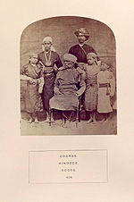 Kodavas, 1875, From "The people of India: A series of photographic illustrations..."(New York Public Library).
According to the 2011 census of India, Kodagu has a population of 554,762,[2] roughly equal to the Solomon Islands[9] or the U.S. state of Wyoming.[10] This ranks it 539 out of 640 districts in India in terms of population.[2] The district has a population density of 135 inhabitants per square kilometre (350 /sq mi).[2] Its population growth rate over the decade 2001–2011 was 1.13%.[2] Kodagu has a sex ratio of 1019 females for every 1000 males,[2] and a literacy rate of 82.52%.[2]
Kodagu is home to many communities with diverse ethnic origins, with Kodavas being the main ethnic group. The ancient folk songs sing of the numerous Kodavas and the much lesser-numbered Amma Kodavas, who were the natives of Kodagu. Other prominent communities are the Kodagu Gowda and Muslims. Kodava and Are Bhashe are the spoken languages native to Kodagu; however, both use the Kannada script for literature. Airi, Male-Kudiya, Meda, Kembatti, Kapal, Maringi, Heggade, Kavadi, Kolla, Thatta, Koleya, Koyava, Banna, Golla, Kanya, Ganiga, and Malaya are other castes native to Kodagu who speak Kodava . Many of these communities had migrated into Kodagu from the Malabar Coast region during the Haleri dynasty. There are also a number of tribes such as the Yeravas, Kurubas and Kudiyas, who are of hunter-gatherer forest origin.[11]
One-fifth of a total population of over 500,000 are the Kodava community, which speak Kodava. The Kodavas Hindus are traditionally ancestor worshippers with a martial tradition, hence may be called Kshatriyas. In Kodagu, the Kodavas were owners of land, the caste of Kembatti Poleya, were the farm labourers who worked for them. They are not vegetarians, but they do not eat beef. They are polytheists and believe in a number of deities. The chief deities are Bhagwathi (Parvati), Mahadeva (Shiva), Bhadrakali (a form of Parvati as Kali or Durga), Subramani (Subramanya) and Ayyappa. Iggutappa, the most important local god, is an incarnation of Subramani, the god of snakes, rain, harvest and rice. Amma Kodavas live in the southern parts of Kodagu and follow some of the Brahmin customs. They were the progeny of intercaste marriages between Brahmins and Kodavas during former times. They belong to 44 family names and two gothras. Unlike other Kodavas they are vegetarians, they abstain from alcohol, wear the sacred thread and study the Vedas. Otherwise they follow the Kodava habits and customs, dress like other Kodavas and speak Kodava Takk. They are also known as Kaveri Brahmins.
The Yerava also live in adjacent Kerala, where they are known as the Adiya, and are primarily Hindu farm-labourers. They speak their own Yerava dialect. The Kurbas were forest hunter-gatherers who are now farm-labourers. They speak their own dialect and belong to two subcastes – Jenu, who are honey-gatherers, and Betta, who are hill-dwellers and good elephant captors, trainers and mahouts. Among other communities are: the Heggades, cultivators from Malabar; the Ayiri, who constitute the artisan caste; the Medas, who are basket and mat-weavers and act as drummers at feasts; the Binepatta, originally wandering musicians from Malabar, now farmers; and the Kavadi, cultivators from Yedenalknad. The Kudiya are of Malabarese tribe origin, they were toddy-makers. All these groups speak the Kodava takk language and conform generally to Kodava customs and dress.[11]
The Arebhashe gowdas,[12] or Kodagu Gowdas, and Tulu Gowdas, are a major ethnic group in the Kodagu and some parts of Dakshina Kannada.[13] More than half of the population in Madikeri taluk consists of Gowdas, they are almost fully occupied in Virajpet and Somwarpet taluks of Kodagu and Sullia, Puttur, Subramanya of Dakshina Kannada. Guddemane Appaiah Gowda along with many other freedom fighters revolted against the British in an armed struggle which covered entire Kodagu and Dakshina Kannada. This was one of the earliest freedom movement against the British[14] called "Amara Sulliada Swantantrya Sangraama"[15]("Amara Sulya Dhange"[14] formally called by the British) started in 1837.
Kodagu is home to a sizeable population of Muslims. Those who speak Urdu and are of Persian (or sometimes Arab or Afghan) origins call themselves Sheikhs but are locally known as the Turks (Turqa). They settled when the Mysore sultans ruled Kodagu. Those of South Indian origins are either known as the Mappilla or as the Beary. Descendants of Kodava Hindus converted by Tipu Sultan into Islam are called Kodava Mappilla, or Jamma Mappillas (not to be confused with the more numerous Kerala Moplahs). Muslims from the Malabar coast, the Mappilas (Kerala Moplahs), have also been present as traders and entrepreneurs. Of the Muslims, the most numerous are the Mappilas, who emigrated from Kerala, the Sheikhs, the Tulunad origin Beary community and then the Kodava Mapillas.[16] A small number of Mangalorean Catholics are also found in Kodagu. They are mostly descended from those Konkani Catholics who fled the roundup and later, captivity by Tippu Sultan. These immigrants were welcomed by Raja Virarajendra (himself a former captive of Tippu Sultan, having escaped six years of captivity in 1788) who realizing their usefulness and expertise as agriculturists, gave them lands and tax breaks and built a church for them.[17] There is a sizeable population of the Lingayat people and the majority of them are in the taluk of Somwarpet. There are also about 52 Lingayat mathas in the district which have taken up the social service like free education and boarding to those children from the vulnerable sections of the society.
Economy
Kodagu is a rural region with most of the economy based on agriculture, plantations and forestry, as well as one of the more prosperous parts of Karnataka. This is due primarily to coffee production and other plantation crops.
Rice and other crops are cultivated in the valleys. Coffee plantations, situated on hillsides too steep for growing rice, and taking advantage of shade from existing forests, became characteristic of the district in the 20th century. Today[when?] coffee is a major cash crop. Coffee processing is also becoming a major economic contributor. In recent years tourism has also begun to play a role in the economy. Eco-tourism, such as walking and trekking tours, take advantage of plantation buildings converted into guest-houses.
Festivals of Kodagu
Kailpodhu
Kailpodhu, celebrated on 3 September, signifies the completion of "nati", or the transplantation of the rice crop. Officially, the festival begins 18 days after the sun enters the Simha Raasi (the western sign of Leo). Kail means weapon or armory and Pold means festival.
The festival signifies the day when men should prepare to guard their crop from wild boars and other animals, since during the preceding months, during which the family were engaged in the fields, all weapons were normally deposited in the Kanni Kombare, or the prayer room. Hence on the day of Kailpoldu, the weapons are taken out of the Pooja room, cleaned and decorated with flowers. They are then kept in the Nellakki Nadubadec, the central hall of the house and the place of community worship. Each member of the family has a bath, after which they worship the weapons before feasting and drinking. The eldest member of the family hands a gun to the senior member of the family, signifying the commencement of the festivities. The whole family assembles in the mand (open ground), where physical contests and sports, including marksmanship, are conducted. In the past the hunting and cooking of wild game was part of the celebration, but today[when?] shooting skills are tested by firing at a coconut tied onto the branch of a tall tree.
Traditional rural sports, like grabbing a coconut from the hands of a group of 8–10 people (thenge porata), throwing a stone the size of a cricket ball at a coconut from a distance of 10–15 paces (tenge eed), lifting a stone ball of 30–40 cm lying at one's feet and throwing it backwards over the shoulders, are now conducted in community groups called Gowda Samajas and Kodava Samajas in towns and cities.
Kaveri Sankramana
The Kaveri Sankramana festival normally takes place in mid-October. It is associated with the river Kaveri, which flows through the district from its source at Talakaveri.
At a predetermined time, when the sun enters Tula Rasi (Tula sankramana), a fountain from a small tank fills the larger holy tank at Talakaveri. Thousands of people gather to dip in this holy water. The water, called tirtha, is collected in bottles and distributed to every home throughout Kodagu to be preserved. A spoonful of this water is fed to the dying, in the belief that they will attain moksha (spiritual emancipation) and gain entry to heaven.
On this day, married women wearing new silk saris perform puja to a vegetable, symbolizing the goddess Kaveri. The vegetable is usually a cucumber or a coconut, wrapped in a piece of red silk cloth and decorated with flowers and jewels (mainly 'Pathak' (Kodava Mangalasuthra)). This is called the Kanni Puje. Kanni refers to the goddess Parvati, who incarnated as Kaveri. Three sets of betel leaves and areca nut are kept in front of the goddess with bunches of glass bangles. All the members of the family pray to the goddess by throwing rice and prostrating themselves before the image. The elder members of the family ceremonially bless the younger. Then an older married woman draws water from the well and starts cooking. The menu of the day is dosa and vegetable curry (usually pumpkin curry (kumbala kari)) and payasa (sweet dish). Nothing but vegetarian food is cooked on this day, and this is the only festival among the Kodavas where only vegetarian food is had and served.
Puttari
Puttari means new rice and is the rice harvest festival (also called huttari in the adjacent Kannada-speaking country). This takes place in late November or early December. Celebrations and preparations for this festival start a week in advance.
On the day of Puttari, the whole family assembles in their ain mane (the common family house), which is decorated with flowers and green mango and banana leaves. Specific foods are prepared: tambuttu, puttari, kari and poli poli. Then the eldest member of the family hands a sickle to the head of the family and one of the women leads a procession to the paddy fields with a lit lamp in her hands. The path leading to the field is decorated. A gunshot is fired to mark the beginning of the harvest, with chanting of "Poli Poli Deva" (prosperity) by all present. Then the symbolic harvesting of the crop begins. The rice is cut and stacked and tied in odd numbers and is carried home to be offered to the gods. The younger generation then light firecrackers and revel, symbolizing prosperity. Groups of youngsters visit neighboring houses and boast their dancing skills and are given monetary gifts. A week later, this money is pooled and the entire village celebrates a communal dinner. All family members gather for this meal. Dinner normally consists of meat dishes, such as pork and fish curry. Alcoholic beverages are also served at such feasts.
Tourist attractions
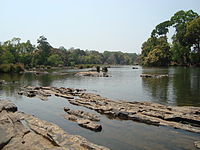 Kaveri River in Kushal Nagar
Talakaveri: the place where the River Kaveri originates. The temple on the riverbanks here is dedicated to lord Brahma, and is one of only two temples dedicated to Brahma in India and Southeast Asia.
Nisargadhama: An man made island and picnic spot near Kushalanagara, formed by the river Kaveri.
Iruppu Falls: A sacred spot in south Kodagu in the Brahmagiri hill range. The Lakshmana Tirtha River flows nearby.
Abbey Falls: a scenic waterfall 5 km from Madikeri.
Dubare: mainly an elephant-capturing and training camp of the Forest Department at the edge of Dubare forest; on the bank of the river Kaveri along the Kushalanagara - Siddapur road.
Nagarahole: a national park and wildlife resort.
Bhagamandala: situated at the confluence of two rivers, the Kaveri and the Kanika. A third river, the Sujyothi, is said to join from underground.
Dargah Sharief, the Holy Tomb, of Yemmemadu is one of the most sacred shrines for Muslims in Kodagu district. (35 km from Madikeri; Madikeri-Bettageri-Napoklu-Hale Taluku-Yemmemadu)
Mandalapatti: 28 km from Madikeri. On the way to Abbey Falls, before 3 km from Abbey Falls take right, from there 25 km.
Mallalli falls: 25 km from Somwarpet, downhill of the Pushpagiri hills
Omkareshwara Temple: A beautiful temple in Coorg. A legend is associated with the temple, built by Lingrajendra II in 1820 CE. The king put to death a pious Brahmin who dared to protest against his misdeeds. The spirit of the dead man began to plague the king day and night. On the advise of wise men, the king built this temple and installed a shivlinga procured from Kashi, North India.
Transport
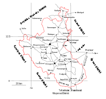 Road map of the district.
Madikeri is well connected by road with Mangalore, Hassan, Mysore, Bangalore and Kannur, Thalassery, and Wayanad of neighbouring state Kerala. There are three Ghat roads for reaching Kodagu from coastal regions of Kerala and Karnataka: the Sampaje–Madikeri Ghat road from Mangalore, the Panathur–Bhagamandala Ghat road from Kanhangad and Kasaragod and the Makutta–Perumbadi/Virajpet Ghat road from Kannur and Thalassery.
The nearest railway stations are Thalassery and Kannur in Kerala and Mangalore, Mysore and Hassan are the nearest in Karnataka.
The nearest airports are at Mysore and Mangalore. Mysore Airport is at a distance of 130 km from Madikeri and 115 kilometres (71 mi) from Virajpet. Mangalore International Airport is located 140 kilometres (87 mi) from Madikeri and 172 kilometres (107 mi) from Virajpet.
The nearest seaport for Kodagu is New Mangalore Port at Panambur in Mangalore, 145 kilometres (90 mi) from Madikeri.
Notable people from Kodagu
Main article: List of Kodavas- Field Marshal K. M. Cariappa
- General K. S. Thimayya
- Lt Gen Apparanda Aiyappa
- C B Muthamma, first woman IFS officer
- P. K. Monnappa police officer
- Gundu Rao, ex-chief minister of Karnataka
- Prema Cariappa, former mayor of Bangalore, Rajya Sabha MP
- Prema (actress), Kannada actress.
- Biddu Appaiah, music composer
- Arjun Halappa, hockey player
- M. P. Ganesh, former hockey team captain, Olympian and coach, 1973 Arjuna Award.
- B. P. Govinda, team hockey player, 1975 Arjuna Award.
- Ashwini Nachappa, athlete, 1988 Arjuna Award
- Prasad Bidapa, fashion designer, choreographer, model trainer.
- Joshna Chinappa, squash player
- Robin Uthappa, international cricket player
- Rohan Bopanna, tennis player
Colleges
- College of Forestry, Ponnampet, UAS (B).
- Coorg Institute of Technology, Ponnampet.
- Coorg Institute of Dental sciences, Virajpet
- Government Engineering College, Kushalnagar.
Notes
- ^ a b "Kodagu district Profile". DSERT. http://dsert.kar.nic.in/dietwebsite/kodagu/DistrictProfile.htm. Retrieved 11 January 2011.
- ^ a b c d e f g "District Census 2011". Census2011.co.in. 2011. http://www.census2011.co.in/district.php. Retrieved 2011-09-30.
- ^ "Kodava-speaking people seek one identity". The Hindu. http://www.hinduonnet.com/thehindu/2003/01/17/stories/2003011701610300.htm.
- ^ "Will Kodava find a place in Eighth Schedule". The Hindu. http://www.hinduonnet.com/2002/08/29/stories/2002082906010300.htm.
- ^ "Debate on Kodava script continues". The Hindu. http://www.hinduonnet.com/thehindu/thscrip/print.pl?file=2006031206840300.htm&date=2006/03/12/&prd=th&. German multi-linguist devises a script with 34 alphabets
- ^ "Codava National Council sets up global forum". The Hindu. http://www.hinduonnet.com/2005/02/11/stories/2005021101650300.htm.
- ^ "Dharna staged for Kodagu State". The Hindu. http://www.hinduonnet.com/2005/02/04/stories/2005020402470300.htm.
- ^ "Districts of India". Government of India. http://india.gov.in/knowindia/districts/andhra1.php?stateid=KA. Retrieved 11 January 2011.
- ^ US Directorate of Intelligence. "Country Comparison:Population". https://www.cia.gov/library/publications/the-world-factbook/rankorder/2119rank.html. Retrieved 2011-10-01. "Solomon Islands 571,890 July 2011 est."
- ^ "2010 Resident Population Data". U. S. Census Bureau. http://2010.census.gov/2010census/data/apportionment-pop-text.php. Retrieved 2011-09-30. "Wyoming 563,626"
- ^ a b K S Rajyashree, Kodava speech community : An ethnolinguistic study
- ^ http://www.jstor.org/pss/598584?cookieSet=1
- ^ "Kodavas seek change in BC category tag". The Hindu (Chennai, India). 26 November 2004. http://www.hindu.com/2004/11/26/stories/2004112606910300.htm.
- ^ a b http://www.usiofindia.org/article_Jan_Mar06_14.htm
- ^ South Kanara, 1799-1860 By N. Shyam Bhatt
- ^ Indian census data
- ^ Sarasvati's Children: A History of the Mangalorean Christians, Alan Machado Prabhu, I.J.A. Publications, 1999, p. 229
Further reading
- Murphy, Devrala.On a Shoestring to Coorg.
- Prabhakaran. N.Kutaku kurippukal (Coorg Notes).Kannur:Kairali Books.
External links

Dakshina Kannada district Hassan district Kasaragod district, Kerala 
Mysore district  Kodagu district

Kinnaur district, Kerala Wayanad district, Kerala Kodagu (Coorg) topics Geography Society Towns Tourism Abbey Falls · Bhagamandala · Dubare · Honnamana Kere · Irupu Falls · Mallalli Falls · Nagarhole National Park · Nisargadhama · Pushpagiri Wildlife Sanctuary · Talakaveri · Harangi ReservoirPeople K.M. Cariappa · K.S. Thimayya · Rohan Bopanna · Arjun Halappa · Robin Uthappa · Gundu Rao · C.B. Muthamma · Prema Cariappa · M.P. Ganesh · B.P. Govinda · Ashwini Nachappa · Prema · Prasad Bidapa · Nikhil Chinnappa · N. Ponnappa · Biddu Appaiah · Joshna Chinappa · Len AiyappaAspirant states of India Bodoland (Assam) · Bundelkhand (Uttar Pradesh and Madhya Pradesh) · Delhi · Gondwana (northern Deccan Plateau) · Gorkhaland (West Bengal) · Harit Pradesh (Uttar Pradesh) · Kamtapur / Greater Cooch Behar (West Bengal) · Karbi Anglong (Assam) · Kodagu (Karnataka) · Kongu Nadu (Tamil Nadu) · Kosal/Koshal (Orissa) · Ladakh (Jammu and Kashmir) · Mahakoshal (Madhya Pradesh) · Mithila (Bihar) · Panun Kashmir (Jammu and Kashmir) · Purvanchal (Uttar Pradesh) · Rayalaseema (Andhra Pradesh) · Telangana (Andhra Pradesh) · Tulu Nadu (Karnataka and Kerala) · Vidarbha (Maharashtra) · Maru Pradesh (Rajasthan) · Vindhya Pradesh (Madhya Pradesh)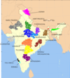 Categories:
- Kodava Takk
- Districts of Karnataka
- Proposed states and union territories in India
- Tourism in Karnataka
- Kodagu district


Wikimedia Foundation. 2010.