- Coprates quadrangle
-
The Coprates quadrangle is one of a series of 30 quadrangle maps of Mars used by the United States Geological Survey (USGS) Astrogeology Research Program. The Coprates quadrangle is also referred to as MC-18 (Mars Chart-18).[1]
The Coprates quadrangle goes from 45° to 90° west longitude and 0° to 30° south latitude on Mars.
Contents
Valles Marineris Canyon System
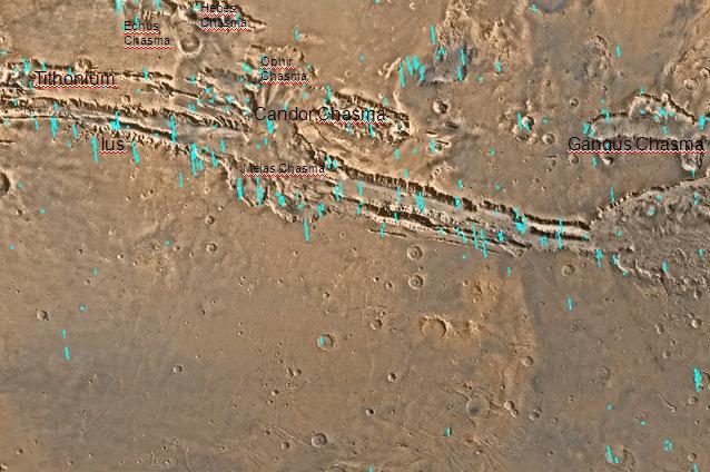
Valles Marineris is an exciting place which sports the largest canyon system in the solar system; this great canyon would go almost all the way across the United States. The name for the whole system of canyons is Valles Marineris. Starting at the west with Noctis Labyrinthus in the Phoenicis Lacus quadrangle, the canyon system ends in the Margaritifer Sinus quadrangle with Capri Chasma and Eos Chasma (in the south). The word Chasma has been designated by the International Astronomical Union to refer to an elongate, steep-sided depression. Valles Marineris was discovered by and named for the Mariner 9 mission. Moving east from Noctis Labyrinthus, the canyon splits into two troughs, Tithonium Chasma and Ius Chasma (in the south). In the middle of the system are the very wide valleys of Ophir Chasma (north), Candor Chasma, and Melas Chasma (south). Going farther to the east, one comes to Coprates Chasma. At the end of Coprates Chasma, the valley gets wider to form Capri Chasma in the north and Eos Chasma in the south. The walls of the canyons often contain many layers. The floors of some of the canyons contain large deposits of layered materials. Some researchers believe that the layers were formed when water once filled the canyons.[2][3][4] The canyons are deep as well as long. In places they are 8-10 kilometers deep. Remember the Earth's Grand Canyon is only 1.6 kilometers deep.[5]
In a study published in the journal Geology in August 2009, a group of scientists led by John Adams of the University of Washington in Seattle, proposed that Valles Marineris may have formed from a giant collapse when salts were heated up thereby releasing water which rushed out carrying mud through underground plumbing. One point that supports this idea is that sulfate salts have been found in the area. These salts contain water which comes off when heated. Heat may have been generated by volcanic processes. After all, a number of huge volcanoes are nearby.[6]
-
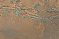
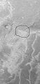
Map of Coprates quadrangle showing details of Valles Marineris, the largest canyon system in the solar system. Some of the canyons may have once been filled with water.
-

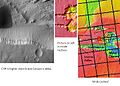
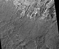
Melas Chasma, as seen by THEMIS. Click on image to see relationship of Melas Chasma to other features.
-
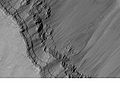
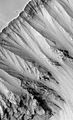
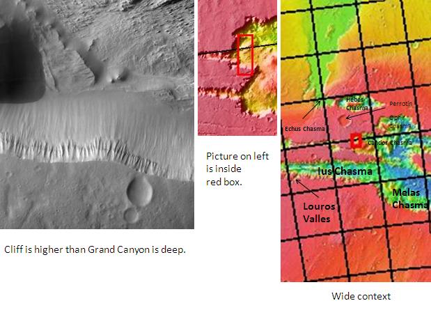
Cliff in Candor Chasma Plateau, as seen by THEMIS. Click on image to see relationship with other features in Coprates quadrangle.
-

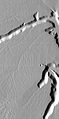
Cliff in northern wall of Ganges Chasma, as seen by THEMIS. Click on image to see relationship with other features in the Coprates quadrangle.
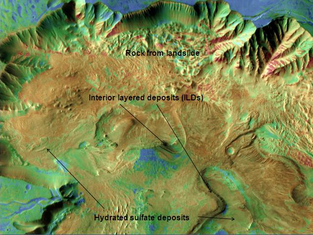
Interior layered deposits and sulfate
Parts of the floor of Candor Chasma contains layered deposits that have been termed interior layered deposits (ILD's). These layers may have formed when the whole area was a giant lake. Some places on Mars contain hydrated sulfate deposits. Sulfate formation involves the presence of water. The European Space Agency's Mars Express found possible evidence of the sulfates epsomite and kieserite. Scientists want to visit these areas with robotic rovers.[7]
Layers
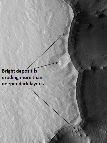
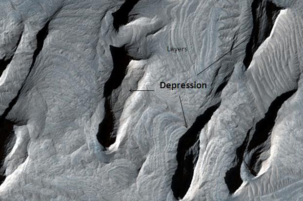
Images of rocks in the canyon walls almost always show layers. Some layers appear tougher than others. In the image below of Ganges Chasma Layers, as seen by HiRISE, one can see that the upper, light-toned deposits are eroding much faster than the lower darker layers. Some cliffs on Mars show a few darker layers standing out and often breaking into large pieces; these are thought to be hard volcanic rock instead of soft ash deposits. An example of hard layers is shown below in the picture of layers in the canyon wall in Coprates, as seen by Mars Global Surveyor. Because of its closeness to the Tharsis volcanic region, the rock layers may be made of layer after layer of lava flows, probably mixed with deposits of volcanic ash that fell out of the air following big eruptions. It is likely the rock strata in the walls preserve a long geological history of Mars.[8] Dark layers may be due to dark lava flows. The dark volcanic rock basalt is common on Mars. However, light-toned deposits may have resulted from rivers, lakes, volcanic ash, or wind blown deposits of sand or dust.[9] The Mars Rovers found light-toned rocks to contain sulfates. Probably having been formed in water, sulfate deposits are of great interest to scientists because they may contain traces of ancient life.[10] The Mars Reconnaissance Orbiter Compact Reconnaissance Imaging Spectrometer for Mars (CRISM) instrument found opaline silica in certain strata along and within the Valles Marineris canyon system.[11] Because Iron sulfates were sometimes found near the opaline silica, it is thought that the two deposits were formed with an acid fluid.[12]
-

Ganges Chasma Layers, as seen by HiRISE.
-
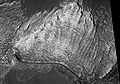
Layers in the canyon wall in Coprates, as seen by Mars Global Surveyor.
-

Layers in Monument Valley. These are accepted as being formed, at least in part, by water deposition. Since Mars contains similar layers, water remains as a major cause of layering on Mars.
-

Layers west of Juventae Chasma, as seen by HiRISE. Scale bar is 500 meters long.
-

Orson Welles Crater, as seen by HiRISE. Layered, light-toned rocks seem to be under a dark mantling material. Layers may be sandstone, volcanic ash, or lakebed deposits.
-

Corprates Chasma Fault, as seen by HiRISE. Layers in the rock face may be from volcanic, lacustrine, and/or aeolian sediments deposited in Valles Marineris.
-

Ritchey Crater layers, as seen by HiRISE. The dark cap layer seems to be resistant to erosion, while the white middle layer is weak. Click on image to see more details. Scale bar is 500 meters long.
-
Light colored layers in Eos Chaos, as seen by HiRISE.
-

Two views of Melas Chasma Layered Deposits, as seen by HiRISE. Left picture lies north of other picture on the right. Pictures are not the same scale. Click on image to see details of layers.
-
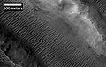
Tithonium Chasma Layers, as seen by HiRISE.
Herbes Chasma and hydrated deposits
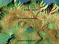
Herbes Chasma, a large enclosed valley, may have once held water. Hydrated minerals have been found there. It is thought that large-scale underground springs of groundwater at different times burst to the sufrace to form deposits called Light Toned Deposits (LTD's). Some suggest present or fossilized life forms may be found there because the deposits are relatively young.[13]
Nirgal Vallis and sapping
Nirgal Vallis is one of the longest valley network on Mars. It is so large that it is found on more than one quadrangle. Scientists do not know how all the ancient river valleys were formed. There is evidence that instead of rain or snow, the water that formed the valleys originated under ground. One mechanism that has been advanced is sapping.[14] In sapping, the ground just gives away as water comes out. Sapping is common in some desert areas in America's Southwest. Sapping forms alcoves and stubby tributaries. These features are visible in the picture below of Nigal Vallis taken with Mars Odyssey's THEMIS.
-

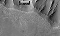
Nirgal Vallis that runs in two quadrangles has features looking like those caused by sapping. Picture taken with THEMIS.
Inverted Relief
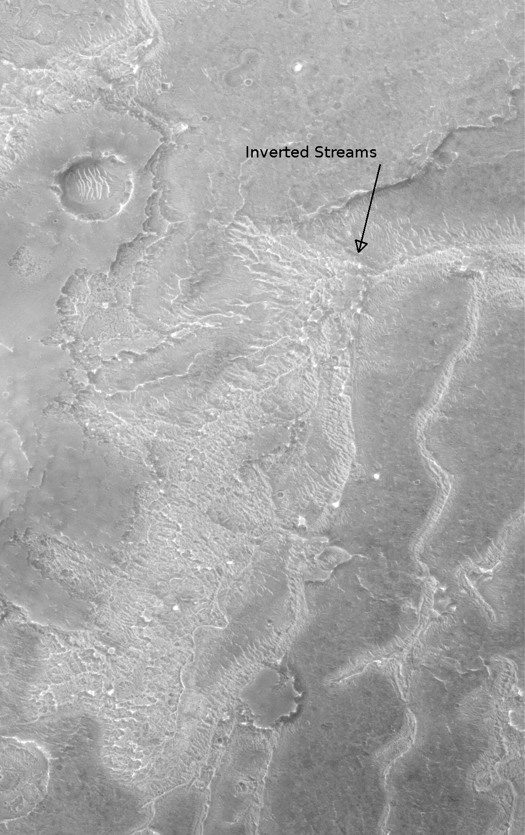
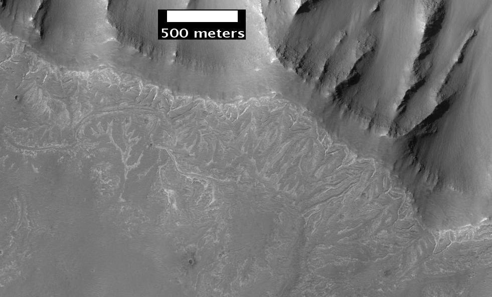
Some areas of Mars show inverted relief, where features that were once depressions, like streams, are now instead above the surface. These may have been formed when materials, like large rocks, were deposited in low-lying areas, then left behind after erosion (perhaps wind which can not move large rocks) removed much of the surface layers. Other ways of making inverted relief might be lava flowing down a stream bed or materials being cemented by minerals dissolved in water. On Earth, materials cemented by silica are highly resistant to all kinds of erosional forces. Inverted relief in the shape of streams are further evidence of water flowing on the Martian surface in past times. There are many examples of inverted channels near Juventae Chasma; some are shown in the image of Juventae Chasma below.[15][16][17]
-

Inverted Channels near Juventae Chasma, as seen by HiRISE. Channels were once regular stream channels. Scale bar is 500 meters long.
-
Inverted Streams near Juventae Chasma, as seen by Mars Global Surveyor. These streams begin at the top of a ridge then run together.
Vallis
Vallis (plural valles) is the Latin word for valley. It is used in planetary geology for the naming of landform features on other planets.
Vallis was used for old river valleys that were discovered on Mars, when probes were first sent to Mars. The Viking Orbiters caused a revolution in our ideas about water on Mars; huge river valleys were found in many areas. Space craft cameras showed that floods of water broke through dams, carved deep valleys, eroded grooves into bedrock, and traveled thousands of kilometers.[5][18][19]
-

Her Desher Valles, as seen by HiRISE.
-
Her Desher Valles close-up, as seen by HiRISE.
Other Features in the Coprates quadrangle
-
False color image of Candor Chasma showing locations of hydrated sulfate deposits, as seen by THEMIS. Red colors show rocky places. Greens and blues show sandy, dusty areas.
-

Channels in Candor plateau, as seen by HiRISE. Location is Coprates quadrangle. Click on image to see many small, branched channels which are strong evidence for sustained precipitation.
-
Melas Chasma Fluvial Channels, as seen by HiRISE. Click on image to see meandering and branching channels made with running water in the past.
-

Branching channels on floor of Melas Chasma. Image taken with THEMIS.
-

Ganges Mensa, as seen by HiRISE.
-

Capri Mensa, as seen by HIRISE. Click on image to see buttes and layers.
-
Ophir Chasma Wall, as seen by HiRISE.
-

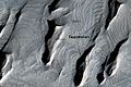
Ius Chasma, as seen by HiRISE. Click on image to see layers.
-

Ius Chasma Floor Layers, as seen by HiRISE. Scale bar is 500 meters long.
-

Ius Chasma Mesa, as seen by HiRISE. Scale bar is 500 meters long.
-
Channels near the rim of Ius Chasma, as seen by HiRISE. The pattern and high density of these channels support precipitation as the source of the water. Location is Coprates quadrangle.
-

Juventae Chasma Troughs, as seen by HiRISE.
-

Channels West of Echus Chasma. The fine pattern of branching stream beds were probably formed from water moving across the surface. Image taken with THEMIS.
-
Dendritic channels on mesa of Echus Chasma. Image is 20 miles wide. Image taken with THEMIS.
See also
- Water on Mars
- Geology of Mars
- Vallis
- Chasma
- Inverted Relief
External links
References
- ^ Davies, M.E.; Batson, R.M.; Wu, S.S.C. “Geodesy and Cartography” in Kieffer, H.H.; Jakosky, B.M.; Snyder, C.W.; Matthews, M.S., Eds. Mars. University of Arizona Press: Tucson, 1992.
- ^ McCauley, J. 1978. Geologic map of the Coprates quadrangle of Mars. U.S. Geol. Misc. Inv. Map I-897
- ^ Nedell, S., et al. 1987. Origin and evolution of the layered deposits in the Valles Marineris, Mars. Icarus. 70: 409-441.
- ^ Weitz, C. and T. Parker. 2000. New evidence that the Valles Marineris interior deposits formed in standing bodies of water. LPSC XXXI. Abstract 1693
- ^ a b Hugh H. Kieffer (1992). Mars. University of Arizona Press. ISBN 9780816512577. http://books.google.com/books?id=NoDvAAAAMAAJ. Retrieved 7 March 2011.
- ^ http://www.space.com/scienceastronomy/090825-st-mars-brine.html
- ^ http://themis.asu.edu/features/candorchasma
- ^ http://themis.asu.edu/features/coprateschasma
- ^ http://hirise.lpl.arizona.edu/PSP_005385_1640
- ^ http://hirise,lpl.arizona.edu/PSP_007430_1725
- ^ Murchie, S. et al. 2009. A synthesis of Martian aqueous mineralogy after 1 Mars year of observations from the Mars Reconnaissance Orbiter. Journal of Geophysical Research: 114.
- ^ Milliken, R. et. al. 2008. Opaline silica in young depsoits on Mars. Geology: 847-850
- ^ http://www.universetoday.com/2008/12/11/Groundwater May Have Played Important Role in Shaping Mars
- ^ http://themis.la.asu.edu/zoom-20030916a.html
- ^ http://hirise.lpl.arizona.edu/PSP_006770_1760
- ^ Malin, M., et al. 2010. An overview of the 1985-2006 Mars Orbiter Camera science investigation. http://marsjournal.org
- ^ www.sciencedirect.com/science/journal/00191035
- ^ Raeburn, P. 1998. Uncovering the Secrets of the Red Planet Mars. National Geographic Society. Washington D.C.
- ^ Moore, P. et al. 1990. The Atlas of the Solar System. Mitchell Beazley Publishers NY, NY.
Quadrangles on Mars MC-01 Mare Boreum
(features)MC-05 Ismenius Lacus
(features)MC-06 Casius
(features)MC-07 Cebrenia
(features)MC-02 Diacria
(features)MC-03 Arcadia
(features)MC-04 Acidalium
(features)MC-12 Arabia
(features)MC-13 Syrtis Major
(features)MC-14 Amenthes
(features)MC-15 Elysium
(features)MC-08 Amazonis
(features)MC-09 Tharsis
(features)MC-10 Lunae Palus
(features)MC-11 Oxia Palus
(features)MC-20 Sinus Sabaeus
(features)MC-21 Iapygia
(features)MC-22 Mare Tyrrhenum
(features)MC-23 Aeolis
(features)MC-16 Memnonia
(features)MC-17 Phoenicis Lacus
(features)MC-18 Coprates
(features)MC-19 Margaritifer Sinus
(features)MC-27 Noachis
(features)MC-28 Hellas
(features)MC-29 Eridania
(features)MC-24 Phaethontis
(features)MC-25 Thaumasia
(features)MC-26 Argyre
(features)MC-30 Mare Australe
(features)Categories: -


Wikimedia Foundation. 2010.