- Corowa
-
Corowa
New South Wales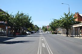
A view of the main street of Corowa
 Corowa
Population: 5,628[1] Established: 1858 Postcode: 2646 Coordinates: 35°59′S 146°23′E / 35.983°S 146.383°ECoordinates: 35°59′S 146°23′E / 35.983°S 146.383°E Elevation: 143 m (469 ft) Location: LGA: Corowa Shire Council County: Hume State District: Albury Federal Division: Farrer Mean max temp Mean min temp Annual rainfall 22.5 °C
73 °F8.8 °C
48 °F539.4 mm
21.2 inCorowa (
 /ˈkɒrəwə/)[2] is a town in the state of New South Wales in Australia. It is on the bank of the Murray River, the border between New South Wales and Victoria, opposite the Victorian town of Wahgunyah. Corowa is the administrative centre of Corowa Shire. The name could have derived from an Aboriginal word referring to the curra pine which yielded gum used by Aborigines to fasten the heads of spears to the shafts. Another translation is rocky river.[3]
There are two bridges over the Murray to Wahgunyah in Victoria: the heritage-listed John Foord Bridge and the Federation Bridge (opened on 2 April 2005).
Contents
History
The Bangerang Tribe
The traditional Aboriginal people from the area are the Bangerang tribe.
The tribe of aborigines that inhabited the Corowa area were called, in their own language, the Bangerang Tribe. The name has various spellings in English, varying all the way from Bandjalang through Panderang to Pinegorine.[4]
Foord's punt
John Foord settled on the Murray River near the Ovens junction (on the southern side of the river) in the early 1840s. In about 1843 Foord and a man named Bould examined the country about the present site of Wahgunyah and recommended it to John Crisp, who was the first European to settle in the area. Later Crisp sold his land to John Foord. With the development of steamer transport on the Murray River in the mid-1850s, Foord purchased a punt which was brought up to Wahgunyah by the steamer Leichhardt. Foord built two extensive warehouses which he let to river navigation companies. Traffic was attracted to Foord's punt, leading to the establishment of Corowa township, opposite to Wahgunyah.[5]
Township development
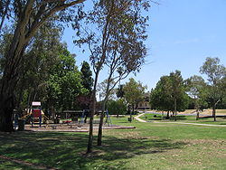 Parkland in Corowa, near the Murray River
Land was surveyed in 1857 at Corowa by Surveyor Adams and the next year the township was proclaimed. In September 1859 a meeting was held to consider the erection of a bridge between Wahgunyah and Corowa to replace the punt. Construction of a bridge was commenced early in 1861 and the completed structure cost about £8,000. The bridge construction was probably privately-funded.[6]
Corowa Post Office opened on 1 January 1861. [7]
In 1861 an Anglican church was built at Corowa on land donated by John Foord.
It was reported in 1868 that Corowa "was fast becoming one of the most important of the border districts". Buildings erected that year included a new store, two hotels and a new court-house.[8]
A branch of the Bank of New South Wales was established in a new brick structure at Corowa in 1874. The building of a Roman Catholic church commenced in September 1874. A report in 1875 stated that Corowa as a township "was making rapid strides". The township had a total of seven hotels. A "private township" had been laid out at Corowa on land formerly owned by Sanger and Foord, with the land selling at £80 to £100 per acre. The Government township, laid out about two miles from the river, was deemed a failure.[6]
A report published in the The Sydney Mail in October 1879 stated that Corowa township consisted of one thoroughfare containing the business houses. On a nearby hill the residences of the wealthier residents had been erected. It was claimed that the Government town of Corowa, two miles from the river, was "a vast wilderness". It was postulated that the reason for the failure of this township to develop was the fact that only one approach to the bridge from that point could be obtained. The toll for crossing the bridge was said to be "somewhat exorbitant," and prevented free intercourse between Corowa and Wahgunyah.[9]
Later developments
In 1882 the bridge between Corowa and Wahgunyah was purchased by the New South Wales Government.[6]
A Presbyterian church and an Oddfellows' Hall were built at Corowa in 1886 .[6]
In the 1890s, Corowa was the site of several important conferences leading to the federation of the various colonies into the Commonwealth of Australia in 1901.
Today
The town in conjunction with nearby town Rutherglen has an Australian Rules football team (Corowa-Rutherglen) competing in the Ovens & Murray Football League.[10]
Prominent people
- George Palmer was a cricketer in the 1880s born in Corowa
- Mike Walsh, television host
- Nigel Lappin is an Australian rules football player born in Corowa
- John Longmire is a retired Australian rules football player (North Melbourne Kangaroos), now coach (Sydney Swans) from Corowa
- Ben Mathews is another Australian rules football player from Corowa (Sydney Swans)
- Stephen Mowlam is an Australian Hockey Player who grew up in, and played hockey for, Corowa
References
- ^ Australian Bureau of Statistics (25 October 2007). "Corowa (State Suburb)". 2006 Census QuickStats. http://www.censusdata.abs.gov.au/ABSNavigation/prenav/LocationSearch?collection=Census&period=2006&areacode=SSC16843&producttype=QuickStats&breadcrumb=PL&action=401. Retrieved 2008-03-31.
- ^ Macquarie Dictionary, Fourth Edition (2005). Melbourne, The Macquarie Library Pty Ltd. ISBN 1-876429-14-3
- ^ "Corowa". Geographical Names Board of New South Wales. http://www.gnb.nsw.gov.au/name_search/extract?id=KWIOFxxOIt. Retrieved 12 July 2009.
- ^ Burton, Brian (1973). Flow Gently Past. Corowa: Corowa Shire Council. p. 228. ISBN 0-9599906-1-5.
- ^ Jervis, James, 'The Western Riverina: A History of Its Development', Royal Australian Historical Society Journal and Proceedings, Vol. XXXVIII 1952, pp. 142-4.
- ^ a b c d Jervis, op. cit.
- ^ Premier Postal History. "Post Office List". https://www.premierpostal.com/cgi-bin/wsProd.sh/Viewpocdwrapper.p?SortBy=VIC&country=. Retrieved 2008-04-11
- ^ Jervis, op. cit, citing Pastoral Times (newspaper), 20 June 1868.
- ^ Jervis, op. cit, citing The Sydney Mail (newspaper), 28 October 1879.
- ^ Full Points Footy. "Corowa Rutherglen". http://www.fullpointsfooty.net/Corowa-Rutherglen.htm. Retrieved 2008-07-25[dead link]
Towns in the Corowa Shire Local Government Area Main Article: Local Government Areas of New South WalesCategories:- Towns in New South Wales
- Towns in the Riverina
- Populated places on the Murray River


Wikimedia Foundation. 2010.