- Corregidor Island
-
Corregidor 
Map of Corregidor Island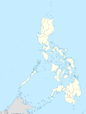
 Corregidor Island (Philippines)
Geography Location Manila Bay Coordinates 14°23′8″N 120°34′23″E / 14.38556°N 120.57306°ECoordinates: 14°23′8″N 120°34′23″E / 14.38556°N 120.57306°E Archipelago Philippine Islands Length 6.5 km (4.04 mi) Width 2.0 km (1.24 mi) Highest elevation 121 m (397 ft) Highest point "Topside", a plateau Country Region CALABARZON Province Cavite Demographics Ethnic groups Tagalog "Corregidor" redirects here. For other uses, see Corregidor (disambiguation).Corregidor Island, locally called Isla ng Corregidor, is a lofty island located at the entrance of Manila Bay in southwestern part of Luzon Island in the Philippines. Due to this location, Corregidor was fortified with several coastal artillery and ammunition magazines to defend the entrance of Manila Bay and the City of Manila, from attacks by enemy warships in the event of war. Located 48 kilometres (30 mi) inland, Manila has been the largest city and the most important seaport in the Philippines for centuries—from the colonial rule of Spain, the United States, and Japan and after the establishment of the Republic of the Philippines in 1946.
Corregidor (Fort Mills) is the largest of the islands that form the harbor defense of Manila Bay together with El Fraile Island (Fort Drum), Caballo Island (Fort Hughes) and Carabao Island (Fort Frank), which were all fortified during the American occupation of the country. The island was also the site of a small military airfield, as part of the defense.
During World War II, Corregidor played an important role during the invasion and liberation of the Philippines from Japanese forces. Heavily bombarded in the latter part of the war, the ruins left on the island serves as a military memorial to several American, Filipino and Japanese soldiers who served or lost their lives on the island. Corregidor is one of the important historic and tourist sites in the country.
Contents
Geography
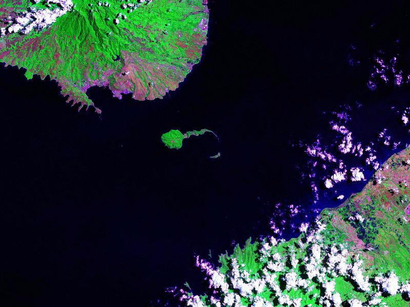
 Corregidor Island and the entrance to Manila Bay.
Corregidor is also known as "The Rock" because of its rocky landscape and heavy fortifications on the island . Its outline is shaped like a tadpole with its tail running eastward. Along with Caballo Island (which lies about 2000 meters south of the "tail's" tip), Corregidor divides the entrance of Manila Bay into the North and South Channel. Corregidor and the other fortified islands fall under the jurisdiction of the province of Cavite.
The island is about 6.5 kilometres (4.0 mi) long, and it is about 2.0 miles (3.2 km) wide at its widest point with a total land area is about 900 hectares (2,200 acres) or roughly 3 square miles (7.8 km2). The island is divided into sections:
Topside
The island's biggest area, which points towards the South China Sea, rises prominently to a large flat area that is called the "Topside". Beneath this was the fortified communications center of the island, as well as the location for the Army headquarters, barracks for enlisted men, a branch of the Philippine Trust Co. bank, the Cine Corregidor movie theater, officers' quarters, underground ordnance shops, the traditional parade grounds, an Officers' Club with a 9-hole Golf Course , tennis courts, and swimming pool, and the bulk of the batteries that constituted the strength of Corregidor.
Middleside
Middleside is a small plateau that interrupts the upward slope from Bottomside to Topside, and was the location of 2-story officers' quarters, barracks for the enlisted men, a hospital, quarters for non-commissioned officers, a service club, PX, and two schoolhouses—one for the children of Filipino soldiers and the other for American children.
Bottomside
 Bottomside in 1982
Bottomside is the lower part of the island and is the neck that connects the tail and head of the island. South of Bottomside was Barangay or Barrio San José (near what was Navy Beach); on the north is what was Army Dock, with its three large piers, and, east of Bottomside, is the Malinta Tunnel. The Malinta Hill separates Bottomside from the Tail End.[1]
Tailside
The Tailside or Tail End is not a given name, but it is the remaining portion of the island where different memorials, shrines and the island's airstrip are located. Kindley Field was constructed in the early 1920s and named in honor of an early hero of the U.S. Army Air Corps. The airfield was operated then by the army, and the navy had a hydroplane base. The short runway, cramped and hilly terrain had limited its use.[2] [3][4]
Geology
Corregidor and Caballo islands are remnants of a volcanic crater, the Corregidor Caldera, which was last active about one million years ago. However, the Philippine Institute of Volcanology and Seismology still classifies Corregidor as a potentially active volcano.
History
Spanish colonial era
The island fell under Spanish sovereignty in May 19, 1570 when Manila Bay (Luzon) was taken by the advancing forces of Miguel Lopez de Legazpi. Legazpi was authorized by the Spanish Crown to establish the capital in Manila and expelling or converting the Muslims from Mindanao and Luzon. Corregidor was used as a support site for the nine Spanish galleys used during the campaign.
Under the Spanish rule, Corregidor served not only as a fortress of defense, a penal institution, and a station for Customs inspection, but also as a signal outpost to warn Manila of the approach of hostile ships. Corregidor came from the Spanish word corregir, meaning "to correct." One story states that, due to the Spanish system wherein all ships entering Manila Bay were required to stop and have their documents checked and corrected, the island was called Isla del Corregidor (literally, Island of Correction). Another version claims that the island was used a penitentiary or correctional institution by the Spanish and came to be called El Corregidor.[5]
On November 23, 1574, the Chinese pirate Limahong and his 65 vessel fleet, with 3,000 men anchored between Corregidor and Mariveles. From that site he launched two successive attacks against Manila, commanded either by Limahong himself or the Japanese Sioco. Both of them failed their purpose before a fierce battle defense led by the governor Juan de Salcedo.
In November and December 1600, the surroundings of Corregidor Island were used as berth by the Dutchman Olivier van Noort. His sailboats Mauritius and Hendracht were engaged in pirate activities on the sailing route to and from Manila. This situation was overcome after the naval combat of Fortune Island on December 14, 1600. As a result, Spain lost its ship San Diego but captured the Dutch sailing boat Hendracht and Oliver van Noort retired from the Philippines.
As a consequence of these events, and also to prevent a sneak attack by the Muslims from Mindanao, a watch vessel was settled in Corregidor to control the entrance to the bay. According to data from 1637, this vessel had a crew of twenty men, who were paid 540 pesos a year to perform this vigilance task.
Corregidor Island was taken over by the Dutch in June 1647 and from there they launched an offensive against Cavite which was repelled by the Spanish garrison, under command of Andre Lopez de Azalduigui. However, the Dutchmen would remain in the island for seven more months as it served them well as an operations base to intercept Chinese merchant traffic in the vicinity of Luzon and Cebu. Finally they withdrew with little of their expectations fulfilled.
During the British attack and its following invasion of Manila and Cavite in October 1762 by the Royal Navy and the British Army troops of Admiral Cornish and General Draper, Corregidor was used as a anchorage for warships, particularly the HMS Panther and the captured warship, the Spanish galleon Santisima Trinidad, during November 1762.
The arrival of the Spanish fleet, led by General Ignacio Mario de Alava, with the mission to place the Philippine Islands on alert, did not affect the luck of Corregidor Island. He limited his activity to the setting up of a naval station at Cavite.
On January 18, 1853, the Corregidor Island Lighthouse was first lit on the highest part of the island to mark the entrance of Manila Bay to vessels coming in from the South China Sea. The Spanish government built the Second-Order light, which is situated 639 feet (195 m) above sea level and visible for 20 miles (32 km).[6]
Spanish-American War
Corregidor Island was included in the Philippines defense plan presented in 1885 by General Cerero, but no action was taken. When the U.S. Navy's attack was thought to be imminent, a 12 cm gun, the "Hontoria System", which came from the Spanish Navy's cruiser Antonio de Ulloa and two shorter ones of the same caliber, from the Spanish warship Lezo, were installed on the rocky island El Fraile. On the south side of Corregidor, the Spanish army installed three 18 cm artillery pieces which came from the Spanish navy cruiser Velasco which was undergoing reparation works.
On the midnight of April 30 to the 1st of May 1898, U.S. Navy Commodore George Dewey led his naval squadron, with his flag hoisted on board the armored cruiser USS Olympia, eastward along the southern coast of Corregidor Island, beyond the reach of Spanish batteries and with no navigational lights on.
At a distance about one mile off El Fraile, Dewey's fleet changed course to the North East, steaming towards Manila. When they were discovered, the Spaniards fired from El Fraile's artillery. American response followed immediately, first by the McCulloc and then by the Boston, Raleigh and Concord. Since the fleet speed was ten knots, they were soon far away from the Spanish batteries. Dewey sailed for Cavite where he destroyed the naval forces of Admiral Monojo.
Once the Cavite shipyard was subdued by means of a Stipulated Pact, two American ships went ashore at Corregidor Island on the 3rd of May forcing the Spaniards on the island to surrender. Colonel Garces, chief of the coast batteries at the entrance of Manila's Bay, and the island's governor, First Class Naval Lieutenant, Augusto Miranda, were urged to come to terms with the Americans, and so they did. Therefore, Miranda remained on the island with only 100 soldiers and the Spanish Flag on top; Garces and officers under his command, as well as 292 men with their weapons and ammunition, were transferred to the Mariveles port. From there they were conducted along the provinces of Bataan and Pampanga until they reached Manila on the 5th of May. There they joined the Navy battalion which was already quartered in Sampaloc.
On the 4th of May, the American ships opened fire against the 100 men who, according to the pact had been left on Corregidor and demanded the garrison forces be reduced to 25 men. The Spanish governor consulted Manila authorities, and they ordered the evacuation of the island. The troops were sent to Naic, Cavite on boats while the governor was transferred to the American cruiser USS Baltimore and became a prisoner with his family. The Americans offered to liberate him but the Navy Lieutenant rejected. Shortly afterwards, he was disembarked in Balanga, Bataan. In this way, the Spanish presence on Corregidor Island, which had lasted 328 years, came to an end.
American Colonial Period
 The entrance to Malinta Tunnel
In 1902, the island was organized as an American military reservation. In 1903, a convalescent hospital was established by the United States Army.
In 1908, a Regular Army post was established on the island, designated as Fort Mills, in honor of Brigadier General Samuel Meyers Mills, Jr., Chief of Artillery of the U.S. Army from 1905 to 1906. By early 1909, H Company of the 2nd Battalion of the Corps of Engineers was assigned to Corregidor and started on the construction of concrete emplacements, bomb-proof shelters, and trails at various parts of the island. This pioneer engineer company left Fort Mills on March 15, 1912. All or part of 35 different numbered Coast Artillery Corps companies served tours at Fort Mills between 1909 and 1923.
The defense of Corregidor was the immediate responsibility of the Philippine Coast Artillery Command, commanded by Major General George F. Moore at the start of World War II. Stationed on the island after the return to the regimental system in 1924 were the following regular units:
- 59th Coast Artillery (U.S. Regular Army)
- 60th Coast Artillery AA (U.S. Regular Army)
- 91st Coast Artillery (Philippine Scouts)
- 92nd Coast Artillery (Tractor Drawn)(Philippine Scouts)
- Headquarters, Harbor Defenses of Manila and the Seaward Defense Command.
The Army post on Corregidor was named Fort Mills, that on Caballo Island (Fort Hughes), on El Fraile Fort Drum, and on Carabao Island, Fort Frank. According to the war plan, these forts were supposed to be able to make a six-month stand, after which aid would presumably come from the United States. The fortifications on Corregidor were designed solely to beat off a seaborne attack. When American military planners realized that airplanes would one day render Fort Mills obsolete, the United States was restricted from improving the fortifications by the Washington Naval Treaty of 1922. After this, the U.S. Army constructed the Malinta Tunnel, with its series of related laterals, to protect its military stores and vital installations in the event of war.
The island, which sheltered Fort Mills, was a prized piece of real estate. Its defense installations had cost the U.S. government more than 150 million dollars. This amount did not include the expenditure for fortifying the neighboring islands of Caballo, Carabao, and El Fraile.
Infrastructure
There were 65 miles (105 km) of paved roads and trails on the island and 19.5 miles (31.4 km) of electric railroad track. The latter were used largely to haul heavy equipment and ammunition from Bottomside to the different Batteries. The Corregidor High School was where children of both Filipino and American servicemen assigned on the island studied. The island also had an electric trolley system as public transport, a movie house (Cine Corregidor), a baseball field and a swimming pool. The business and social center of this community was found on Topside.
Water supply
Before the war and during the siege, Corregidor depended most of its potable water from Bataan. For this purpose, barges were used to haul water either from Mariveles or Cabcaben, Bataan.
World War II
During World War II, Corregidor was the site of two costly sieges and pitched battles—the first during the first months of 1942, and the second in January 1945—between the Imperial Japanese Army and the U.S. Army, along with its smaller subsidiary force, the Philippine Army.
During the Battle of the Philippines (1941–42), the Japanese Army invaded Luzon from the north (at Lingayen Gulf) in early 1942 and attacked Manila from its landward side. The American and Filipino troops under the command of General Douglas MacArthur, retreated into the Bataan Peninsula, west of Manila Bay. The fall of Bataan on April 9, 1942 ended all organized opposition by the U.S. Armed Forces in the Far East (USAFFE) to the invading Japanese forces on Luzon in the northern Philippines. They were forced to surrender due to the lack of food and ammunition. Eventually, Corregidor and its adjacent islets at Manila Bay became the final bastions for holding out against the enemy, antithesis to being the first line of defense for Manila.
Between December 24, 1941 and February 19, 1942, Corregidor became the temporary location for the Government of the Philippines. On December 30, 1941, outside the Malinta Tunnel, Manuel L. Quezon and Sergio Osmeña were inaugurated respectively as President and Vice-President of the Philippines Commonwealth for a second term. General Douglas MacArthur also used Corregidor as Allied headquarters until March 11, 1942. The Voice of Freedom, the radio station of the USAFFE (United States Armed Forces in the Far East) broadcasted from Corregidor, including the famous announcement of the fall of Bataan. In April 1942, one Battalion of the Fourth Marines, were sent to reinforce the island's beach defenses.
The Battle of Corregidor was the culmination of the Japanese campaign for the conquest of the Philippines. The island bastion of Corregidor, with its network of tunnels and formidable array of defensive armament, along with the fortifications across the entrance to Manila Bay, were the remaining obstacle to the 14th Japanese Imperial Army of Lieutenant General Masaharu Homma. The American and Filipino soldiers on Corregidor and the neighboring islets held out against the Japanese to deny the use of Manila Bay, but the Japanese Army brought heavy artillery to the southern end of Bataan, and proceeded to block Corregidor from any sources of food and fresh water. Japanese troops forced the surrender of the remaining American and Filipino forces on May 6, 1942 while under the command of 2nd Lt. Robert L. Obourn, U.S. Army Coast Artillery Corps.
The battle for the recapture of Corregidor occurred between 16th and 26th of February 1945, by American and Filipino forces which liberated the island fortress from the Japanese hands.
Fortifications
 The fortifications on Corregidor
There were 23 batteries installed on Corregidor, consisting of 56 coastal guns and mortars. In addition, Corregidor had 13 anti-aircraft artillery batteries with 76 guns (28 3-inch and 48 .50-caliber) and 10 60-inch Sperry searchlights.
The longest-range coastal pieces were the two 12-inch (305 mm) guns of Batteries Hearn and Smith, with a horizontal range of 29,000 yards (27,000 m). Although capable of an all around traverse, these guns, due to their flat trajectories, were not effective for use against targets on Bataan.
During the siege, the island had ample armor-piercing ammunition but very little of the anti-personnel type, which then was of greatest demand for use against land targets on Bataan. In fact, most of the anti-personnel shells were only for the 12-inch mortars of Batteries Way and Geary.
Battery Way
Main article: Battery WayBattery Way was named in honor of the Coast Artillery Corps of the U.S. Army, which along with Battery Geary, was the mainstay of the Corregidor Garrison during the Japanese invasion. Its mortars, capable of a 360-degree traverse, could fire on land targets at Bataan. They brought the most destruction on Japanese positions during the attempted landings on the southwest coast of Bataan late in January to the middle of February 1942. These mortars were silenced by enemy shelling in May 1942.
Battery Geary
Battery Geary was a battery of eight 13-ton, 12-inch mortars. Defiladed in a hollow on Corregidor's Southern coast it was fairly well protected from Japanese shelling. However, on January 6, 1942, under the command of Capt. Ben Ewing King, a Japanese bomb landed in a makeshift bunker killing 31 of Battery Geary's NCOs and canoneers. Early in the morning of January 26 Battery Geary opened fire on a unit of Japanese soldiers near Longaskawayan Point on the west side of the Bataan Peninsula. Although the fire was considered accurate and effective Col. Bunker decided to replace Capt. King and he was sent to command HQ Battery on Ft. Drum. He was replaced by Capt. Thomas W. Davis. Later, this battery was pinpointed by the Japanese artillery and was subjected to heavy shelling. One direct hit by a 240-mm shell, which detonated the magazines of this battery in May 2,1942, proved to be the most crippling shot during the entire siege of Corregidor. This explosion tossed the fifty ton barrel of the mortar around, one to a distance of 150 yards (140 m), another was blown through three feet of reinforced concrete wall into the adjoining powder magazine of Battery Crockett. Large chunks of steel were blown as far as the Malinta Tunnel, killing 27 of the battery crew instantly. Also, one mortar still had a live round in its breech, and it was in the process of firing the shell when the magazine was hit.
 Aerial view of the ruins
Corregidor today
After the War, many people, most of them veterans, visited the island because of its history. Today, Corregidor is a historic monument as well as a tourist destination. Many travel companies offer day tours on the island featuring military installations used during World War II. Most of the war-ravaged buildings have not been restored, and left how it was after the war in reverence to the Filipino and American soldiers who died there.
Pacific War Memorial
 Marker of the Pacific War Memorial
Standing on the highest part of Corregidor's Topside is the Pacific War Memorial, which was built by the United States Government to honor the Filipino and American soldiers who participated in World War II. It was completed in 1968 at the cost of three million dollars. The major memorial structure is a rotunda with a circular altar directly under the dome's oculus through which light falls on the altar during daylight hours. Located behind the Memorial is the Eternal Flame of Freedom, a 40 feet (12 m) Corten steel structure commissioned to Aristides Demetrios symbolizing freedom.[7]
Malinta Tunnel
The Malinta Tunnel, which is the last stronghold of the joint Philippine and American military prior to the Japanese takeover during the last world war, is now home to an audio-visual presentation by National Artist Lamberto V. Avellana of the events that took place on the island, including the reluctant departure of General Douglas MacArthur and the evacuation of the Philippine president Manuel L. Quezon and his family to unoccupied areas of the Philippines and eventually in exile in the United States.[1]
Filipino Heroes Memorial
One of the most recent additions to Corregidor is the Filipino Heroes Memorial located in the Tail End. This 6,000-square meter complex has 14 murals depicting heroic battles fought by Filipinos from the 15th century up to the present day. It was designed by Francisco Mañosa, while the murals and a statue of a Filipino guerrilla were sculpted by Manuel Casas. The complex was inaugurated by President Fidel V. Ramos on August 28, 1992.[2]
Japanese Garden of Peace
This garden was built as a memorial to the Japanese soldiers who served and died on the island during WWII. The park includes a praying area, shrines, markers and a small pavilion that houses photographs and memorabilia.[2]
Corregidor lighthouse
The lighthouse on Topside is one of the oldest landmarks in Corregidor first lit in 1853. In 1897, the defective lighting apparatus was changed extending the range to 33 miles (53 km). The grounds and keeper's dwellings were further improved during the American occupation. During WWII, the lighthouse was damaged during the siege of Corregidor. The lighthouse was totally reconstructed in the 1950s with a different design and stands on the same spot where the first lighthouse once stood. The whole lantern of the lighthouse was recently replaced by the Philippine Coast Guard to run on solar power.
See also
References
- Notes
- ^ a b "Malinta Tunnel". Corregidor Island Web Site. Retrieved on 2011-03-09.
- ^ a b c "Corregidor Island's Geographic Sectors-Part 2". Corregidor Island Web Site. Retrieved on 2011-03-11.
- ^ Hubbard, Charles M. and Davis Jr., Collis H.. "Corregidor in Peace and War", p.82. University of Missouri Press, Columbia and London, 2006. ISBN 978-0-8262-1712-7.
- ^ Linn, Brian McAllister. "Guardians of Empire: The U.S. Army and the Pacific, 1902-1940", p.203. University of North Carolina, Chapel Hill, 1997. ISBN 0-8078-2321-x.
- ^ History, Corregidor Island.com.
- ^ "El Archipielago Filipino", pp.525-527. Washington: Impriento del Gobierno, 1900.
- ^ "Corregidor Island's Geographic Sectors-Part 1". Corregidor Island Web Site. Retrieved on 2011-03-11.
- Bibliography
- Gerez, M. B. The Story of Corregidor.
External links
- A Glimpse of Life in Corregidor before WWII Part 1
- A Glimpse of Life in Corregidor before WWII Part 2Pa
- By Order of Major Kline
- Corregidor Then and Now
- Fortifications of Luzon
- Ft. Drum (aka El Fraile Island)
- Panoramic pictures of Corregidor
- Photos of Corregidor - MacArthur Memorial
- Recapture of the island
- So Proudly We Hail! (1943) : Wartime film dramatization

Mariveles, Bataan Mariveles, Bataan Manila Bay South China Sea 
Manila Bay  'Corregidor'

El Fraile Naic, Cavite Naic, Cavite
Manila BayGovernment
cultural
agenciesNational Commission for Culture and the Arts · National Historical Commission of the Philippines · National Museum · National Library · National Archives · Cultural Center of the Philippines · Komisyon sa Wikang Filipino · Sentro Rizal
Categories
of cultural
propertiesUNESCO World Heritage Sites · National Cultural Treasures · Important Cultural Properties · National Historical Landmarks · National Shrines · National Monuments · National Heritage Houses · Works of National Artists · Marked Structures · Other Cultural PropertiesCategories:- National Shrines of the Philippines
- Military installations of the Philippines
- United States military in the Philippines
- Cavite
- Islands of the Philippines


Wikimedia Foundation. 2010.