- Municipality of Kiama
-
Municipality of Kiama
New South Wales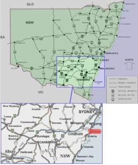
Location of Kiama in New South WalesPopulation: 20,641(2009)[1] Established: 1859 Area: 258 km² (99.6 sq mi) Mayor: Sandra McCarthy Council Seat: Kiama (11 Manning Street)[2] Region: Illawarra State District: Kiama Federal Division: Gilmore LGAs around Municipality of Kiama: Wingecarribee Shellharbour Pacific Ocean Wingecarribee Municipality of Kiama Pacific Ocean Shoalhaven Shoalhaven Pacific Ocean The Municipality of Kiama is a Local Government Area (LGA) in New South Wales, Australia, in the Illawarra region. It is south of Shellharbour and the City of Wollongong and is on the Pacific Ocean, the Princes Highway and the South Coast line.
The Municipality of Kiama includes Kiama and the localities of Bombo, Gerringong, Gerroa, Minnamurra and Jamberoo.
In 1954, the Kiama Municipal Council absorbed the Gerringong Municipal District.
Contents
Council
The Council of the Municipality of Kiama is composed of nine councillors elected proportionally. The mayor is not directly elected.[3] The current makeup of the council is as follows:[3]
Kiama Municipal Council, also has a close friendship with
- *
 Shellharbour, New South Wales, since 1859
Party Councillors Independents and Unaffiliated 7 The Greens 2 Total 9 The current council, elected in 2008, is:[3]
Councillor Party Notes Sandra McCarthy Independent Mayor Ben van der Wijngaart Greens - Brian Petschler Independent Deputy Mayor Lexie Wheeler Independent Elected on Sandra McCarthy's ticket Monique Dare-Ward Greens Trevor Fredericks Independent Elected on Brian Petschler's ticket Peter Bowman Independent Elected on Sandra McCarthy's ticket Warren Steel Independent Neil Reilly Unaffiliated See also
References
- ^ Australian Bureau of Statistics (30 March 2010). "Regional Population Growth, Australia, 2008–09". http://www.abs.gov.au/ausstats/abs@.nsf/Latestproducts/3218.0Main%20Features42008-09?opendocument&tabname=Summary&prodno=3218.0&issue=2008-09&num=&view=. Retrieved 3 June 2010.
- ^ "Council of the Municipality of Kiama". Department of Local Government. http://www.dlg.nsw.gov.au/dlg/dlghome/dlg_CouncilContactDetails.asp?slacode=4400. Retrieved 2006-11-26.
- ^ a b c "Kiama Municipal Council". 2008 Election results. Electoral Commission NSW. http://www.lg.elections.nsw.gov.au/LGE2008/result.Kiama.html. Retrieved 2009-06-17.[dead link]
External links
Local Government Areas of New South Wales Metropolitan Sydney Inner SydneyAshfield · Botany Bay · Burwood · Canada Bay · Canterbury · Hurstville · Kogarah · Lane Cove · Leichhardt · Manly · Marrickville · Mosman · North Sydney · Randwick · Rockdale · Strathfield · Sydney · Waverley · Willoughby · WoollahraOuter SydneyAuburn · Bankstown · Blacktown · Camden · Campbelltown · Fairfield · The Hills · Holroyd · Hornsby · Hunter's Hill · Ku-ring-gai · Liverpool · Parramatta · Penrith · Pittwater · Ryde · Sutherland · WarringahSydney SurroundsMid North Coast Bellingen · Clarence Valley · Coffs Harbour · Greater Taree · Kempsey · Nambucca · Port Macquarie-Hastings · Lord Howe IslandMurray Murrumbidgee Carrathool · Coolamon · Cootamundra · Griffith · Gundagai · Hay · Junee · Leeton · Lockhart · Murrumbidgee · Narrandera · Temora · Wagga WaggaHunter Cessnock · Dungog · Gloucester · Great Lakes · Lake Macquarie · Maitland · Muswellbrook · Newcastle · Port Stephens · Singleton · Upper HunterIllawarra Richmond Tweed Southeastern Bega · Bombala · Boorowa · Cooma-Monaro · Eurobodalla · Goulburn Mulwaree · Harden · Palerang · Queanbeyan · Snowy River · Tumut · Upper Lachlan · Yass Valley · YoungNorthern Armadale Dumaresq · Glen Innes-Severn · Gunnedah · Guyra · Gwydir · Inverell · Liverpool Plains · Moree Plains · Narrabri · Tamworth · Tenterfield · Uralla · WalchaCentral West North Western Far West Categories:- Populated places established in 1859
- 1859 establishments in Australia
- Illawarra region geography stubs
- Local Government Areas of New South Wales
- Alliance for Healthy Cities
- *

Wikimedia Foundation. 2010.