- County of Bourke, Victoria
-
Bourke
Victoria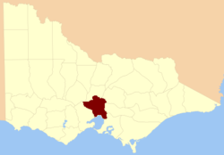
Location in VictoriaLands administrative divisions around Bourke Talbot Dalhousie Anglesey Grant Bourke Evelyn Grant Port Phillip Bay Mornington  1866 map of Bourke County showing the parishes
 1885 map of Bourke County (pink)
 1886 map of Bourke County
The County of Bourke is one of the 37 counties of Victoria which are part of the Lands administrative divisions of Australia, used for land titles. It is the oldest and most populous county in Victoria and contains the city of Melbourne. Like other counties in Victoria, it is subdivided into parishes. The original name for the area was the Port Philip District, which was renamed to Bourke County after Richard Bourke, the governor of New South Wales between 1831 and 1837.[1] It is bordered by the Werribee River in the west; the Great Dividing Range in the north; Port Phillip Bay in the south; and by Dandenong Creek, a small part of the Yarra River, and the Plenty River in the east.
The Melbourne and County of Bourke Police was the name for the police force in the area before 1853. The County of Bourke was used on the name of the electoral roll in 1845.[2] There was also the Bourke County Court in the 1850s[3], which became the County Court of Victoria. Melbourne is also referenced as being in "Bourke county" in the 1911 Britannica.[4]
Parishes
Parishes within the county (many of the links below link to the modern day suburb or town which is usually in the same area as the parish, but not necessarily the same - the parish would be larger than the modern suburb). Several of the parishes were also part of a neighbouring county. These parishes were in Bourke as well as the County of Dalhousie; Bylands, Forbes, Goldie, Lancefield and Newham. Several others were in Bourke and the County of Evelyn; Morang, Toorourrong and Yan Yean. The parish of Ballan was located in Bourke and the County of Grant.
References
External links
Counties1 of Australian capital cities Coordinates: 37°35′S 144°50′E / 37.583°S 144.833°E
Counties of Victoria Anglesey • Benambra • Bendigo • Bogong • Borung • Bourke • Buln Buln • Croajingolong • Dalhousie • Dargo • Delatite • Dundas • Evelyn • Follett • Gladstone • Grant • Grenville • Gunbower • Hampden • Heytesbury • Kara Kara • Karkarooc • Lowan • Millewa • Moira • Mornington • Normanby • Polwarth • Ripon • Rodney • Talbot • Tambo • Tanjil • Tatchera • Villiers • Weeah • Wonnangatta
Categories:- Counties of Victoria (Australia)
- Geography of Melbourne


Wikimedia Foundation. 2010.